Related Research Articles

Käina Parish was a rural municipality of Hiiu County, Estonia on the southeastern part of the island.
Hõralaid is a small, uninhabited Estonian island of approximately 20 hectares in the Baltic Sea. The coordinates of Hõralaid are 58°53′55″N23°04′26″E.
Külalaid is a small island in the Baltic Sea belonging to the country of Estonia. Its coordinates are 58°58′43″N22°24′19″E.

Kadakalaid is a small island in the Baltic Sea belonging to the country of Estonia. Its coordinates are 58°58′55″N23°00′39″E

Vissulaid is a small, uninhabited island in the Baltic Sea belonging to the country of Estonia. Its coordinates are 59°00′40″N22°50′26″E

Kõrgelaid is a small, uninhabited, moraine-based island in the Baltic Sea, belonging to the country of Estonia. Its coordinates 58°45′09″N23°05′35″E.

Saarnaki laid is an uninhabited, moraine-based island in the Baltic Sea belonging to the country of Estonia. Its coordinates are 58°48′38″N22°59′37″E.

Kõverlaid is a small, moraine-based Baltic Sea island belonging to the country of Estonia. Its coordinates are 58°49′01″N23°04′46″E.

Langekare is a small, uninhabited Baltic Sea island belonging to the country of Estonia. Its coordinates are 58°48′21″N23°09′03″E

Luigerahu is a small, moraine-based Baltic Sea island that belongs to the country of Estonia.

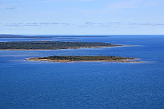
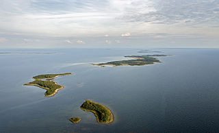
Hanikatsi laid is an islet in Estonia, in the Baltic Sea, south east of Hiiumaa island. It has a surface area of 83 hectares and no permanent habitation. The islet belongs to Hiiu County, Pühalepa Parish and is part of Hiiumaa Islets Landscape Reserve, which in turn is part of West Estonian Archipelago Biosphere Reserve.
Ahelaid is a small uninhabited islet in Estonia. It lies in the Baltic Sea, south-east of Hiiumaa island. It has a surface area of 25 hectares. It is part of the Hiiumaa Islets Landscape Reserve.
Öakse is an island in the Baltic Sea belonging to the country of Estonia.
Käkirahu is an island in the Väinameri strait in the southeastern part of Hiiu County, Estonia. The island has a total area of 170 m² with a coastline length of 57 meters.
Sipelgarahu is an Estonian island in Väinameri Sea, and has size of 3,52 ha. It forms Sipelgarahu Nature Reserve in Matsalu National Park.

Uuemererahu is a small Baltic Sea islet comprising 2.3 hectares in area, belonging to the country of Estonia.
Uuemaarahu is a small, Baltic Sea islet comprising 0.0234 hectares belonging to the country of Estonia.

Reigilaid is a former small islet in the Baltic Sea belonging to the country of Estonia. Now a peninsula of Hiiumaa island.
Liivanuka ots is an Estonian islet with surface area of 0.0059 hectares. It is a sandy, oval-shaped islet, stretching in a north-south direction. It lies southeast of the island of Hiiumaa in the Jausa rand, next to the islet of Hanerahu. Liivanuka ots is part of Hiiumaa Parish, Hiiu County. The islet belongs to Hiiumaa Islets Landscape Reserve.

Hiiu Parish was a rural municipality of Hiiu County, Estonia. It occupied the northwestern part of the Hiiumaa island. The population was about 5000, about 3600 of whom lived in the parish seat.