Külalaid

Last updated

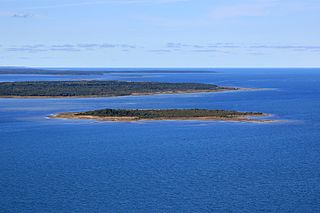
Külalaid is a small island in the Baltic Sea belonging to the country of Estonia. Its coordinates are 58°58′43″N22°24′19″E / 58.97861°N 22.40528°E / 58.97861; 22.40528 .

Baltic Sea A sea in Northern Europe bounded by the Scandinavian Peninsula, the mainland of Europe, and the Danish islands

The Baltic Sea is a marginal sea of the Atlantic Ocean, enclosed by Denmark, Estonia, Finland, Latvia, Lithuania, Sweden, northeast Germany, Poland, Russia and the North and Central European Plain.

Estonia Republic in Northern Europe

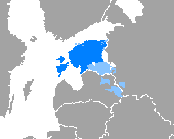
Estonia, officially the Republic of Estonia, is a country in Northern Europe. It is bordered to the north by the Gulf of Finland with Finland on the other side, to the west by the Baltic Sea with Sweden on the other side, to the south by Latvia (343 km), and to the east by Lake Peipus and Russia (338.6 km). The territory of Estonia consists of a mainland and 2,222 islands in the Baltic Sea, covering a total area of 45,227 km2 (17,462 sq mi), water 2,839 km2 (1,096 sq mi), land area 42,388 km2 (16,366 sq mi), and is influenced by a humid continental climate. The official language of the country, Estonian, is the third most spoken Finno-Ugric language.

Külalaid lies just off the northwestern coast of the island of Hiiumaa, as such it is administered by Hiiu County (Estonian : Hiiu maakond). [1] It lies closest to the Paope coastal area of the island and along with Ninalaid, it is one of the larger of the tiny islets of the area.

Hiiumaa second largest island in Estonia

Hiiumaa is the second largest island in Estonia, with an area of 989 km2. It is in the Baltic Sea, north of the island of Saaremaa, part of the West Estonian archipelago. Its largest town is Kärdla. Along with several smaller neighboring islands, the island makes up Hiiu County; one of the 15 counties of Estonia.

Hiiu County County of Estonia

Hiiu County, or Hiiumaa, is one of 15 counties of Estonia, being the smallest county both in terms of area and population. It consists of Hiiumaa, the second largest island of Estonia, and several smaller islands near it. The county borders Lääne County to the east and Saare County to the south.

Estonian language Finno-Ugric language spoken in Estonia

The Estonian language is the official language of Estonia, spoken natively by about 1.1 million people: 922,000 people in Estonia and 160,000 outside Estonia. It is a Southern Finnic language and is the second most spoken language among all the Finnic languages.

Related Research Articles

Lääne County County of Estonia

Lääne County, or Läänemaa, is one of 15 counties of Estonia. It is located in western Estonia and borders the Baltic Sea to the north, Harju County to the north-east, Rapla County to the east, Pärnu County to the south, and the island counties of Saare and Hiiu to the west. In January 2009 Lääne County had a population of 23,810 – constituting 2.0% of the total population in Estonia.

Käina Parish Former municipality of Estonia in Hiiu County

Käina Parish was a rural municipality of Hiiu County, Estonia on the southeastern part of the island.

Hõralaid island

Hõralaid is a small, uninhabited Estonian island of approximately 20 hectares in the Baltic Sea. The coordinates of Hõralaid are 58°53′55″N23°04′26″E.

Kadakalaid is a small island in the Baltic Sea belonging to the country of Estonia. Its coordinates are 58°58′55″N23°00′39″E

Vissulaid island in Hiiumaa Rural Municipality, Estonia

Vissulaid is a small, uninhabited island in the Baltic Sea belonging to the country of Estonia. Its coordinates are 59°00′40″N22°50′26″E

Kõrgelaid island in Estonia (Väinameri)

Kõrgelaid is a small, uninhabited, moraine-based island in the Baltic Sea, belonging to the country of Estonia. Its coordinates 58°45′09″N23°05′35″E.

Ninalaid is a small Baltic Sea island belonging to the country of Estonia. Its coordinates are 58°59′52″N22°26′31″E.

Saarnaki laid island

Saarnaki laid is an uninhabited, moraine-based island in the Baltic Sea belonging to the country of Estonia. Its coordinates are 58°48′38″N22°59′37″E.

Kõverlaid island in Estonia

Kõverlaid is a small, moraine-based Baltic Sea island belonging to the country of Estonia. Its coordinates are 58°49′01″N23°04′46″E.

Langekare is a small, uninhabited Baltic Sea island belonging to the country of Estonia. Its coordinates are 58°48′21″N23°09′03″E

Luigerahu is a small, moraine-based Baltic Sea island that belongs to the country of Estonia.

Hanikatsi laid island in Estonia

Hanikatsi laid is an islet in Estonia, in the Baltic Sea, south east of Hiiumaa island. It has a surface area of 83 hectares and no permanent habitation. The islet belongs to Hiiu County, Pühalepa Parish and is part of Hiiumaa Islets Landscape Reserve, which in turn is part of West Estonian Archipelago Biosphere Reserve.

Ahelaid island in Estonia

Ahelaid is a small uninhabited islet in Estonia. It lies in the Baltic Sea, south-east of Hiiumaa island. It has a surface area of 25 hectares. It is part of the Hiiumaa Islets Landscape Reserve.

Öakse is an island in the Baltic Sea belonging to the country of Estonia.

Uuemererahu is a small Baltic Sea islet comprising 2.3 hectares in area, belonging to the country of Estonia.

Uuemaarahu is a small, Baltic Sea islet comprising 0.0234 hectares belonging to the country of Estonia.

Reigilaid is a small islet in the Baltic Sea belonging to the country of Estonia.

Liivanuka ots is an Estonian islet with surface area of 0.0059 hectares. It is a sandy, oval-shaped islet, stretching in a north-south direction. It lies southeast of the island of Hiiumaa in the Jausa rand, next to the islet of Hanerahu. Liivanuka ots is part of Emmaste Parish, Hiiu County. The islet belongs to Hiiumaa Islets Landscape Reserve.

Hiiu Parish Former municipality of Estonia in Hiiu County

Hiiu Parish was a rural municipality of Hiiu County, Estonia. It occupied the northwestern part of the Hiiumaa island. The population was about 5000, about 3600 of whom lived in the parish seat.

References

See also

List of islands of Estonia