
Umalakotid is an island belonging to the country of Estonia. It is part of Vilsandi National Park. [1]
Umalakotid is an island belonging to the country of Estonia. It is part of Vilsandi National Park. [1]

Saare County is one of 15 counties of Estonia. It consists of Saaremaa, the largest island of Estonia, and several smaller islands near it, most notably Muhu, Ruhnu, Abruka and Vilsandi. The county borders Lääne County to the east, Hiiu County to the north, and Latvia to the south. In 2022 Saare County had a population of 31,292, which was 2.4% of the population of Estonia.
The island of Vilsandi, Saaremaa Parish, Saare County, Estonia is located in the Baltic Sea. It covers an area of some 9 square km and is the westernmost populated island in Estonia. The surrounding waters are shallow and rocky and many ships travelling the Baltic have perished nearby. The island of Vilsandi can be reached by boat, by truck having suitable clearance or on foot by wading from Saaremaa. Much of the island is now part of Vilsandi National Park, which grew from a bird reserve founded in 1910. It is a highly sensitive ecosystem due to the use of the area by many migratory birds as a breeding and nesting ground. Hunting is absolutely prohibited. This park is a popular tourist destination not only for local Estonians, but also people of Finland who are visiting Estonia in greater and greater numbers.
This is a list of the extreme points on land of Estonia: the points that are farther north, south, east or west than any other location.

Kihelkonna Parish was a municipality in Saare County, Estonia.

Vesiloo is a small, uninhabited Estonian island in the Baltic Sea. Its coordinates are 58°23′45″N21°50′35″E.

Vilsandi National Park is a marine protected area in Saaremaa Parish, Saare County, Estonia. It includes part of the island of Vilsandi, a number of smaller islands, adjacent parts of western Saaremaa including Harilaid peninsula.

Harilaid Peninsula is a peninsula on the northwest coast of the island of Saaremaa in Estonia. It should not be confused with the islet of Harilaid which lies between the islands of Vormsi and Hiiumaa.


Loona is a village in Saaremaa Parish, Saare County in western Estonia.
Innarahu is a small, uninhabited Baltic Sea islet belonging to Estonia.
Koerakuiv is a small islet in the Baltic Sea belonging to the country of Estonia. Koerakuiv lies just off the northwest coast of the island of Saaremaa, and is administratively part of Atla village in Saaremaa Parish, Saare County and is also part of Vilsandi National Park.
Kuivarahu may refer to several geographical objects in Estonia:
Püskumadal is a small islet in the Baltic Sea belonging to the country of Estonia. Püskumadal lies just off the northwest coast of the island of Saaremaa, and is administratively part of Atla village in Saaremaa Parish, Saare County and is also part of Vilsandi National Park.
Salavamaa also known as Salava is a small island in the Baltic Sea belonging to the country of Estonia. Salavamaa lies just off the northwest coast of the island of Saaremaa, and is administratively part of Atla village in Saaremaa Parish, Saare County and is also part of Vilsandi National Park.

Urverahu is a small uninhabited islet in the Baltic Sea belonging to the country of Estonia. Urverahu lies just off the northwest coast of the island of Saaremaa, and is administratively part of Atla village in Saaremaa Parish, Saare County and is also part of Vilsandi National Park.

Vaika islands is a group of islands belonging to the country of Estonia. They lie next to Vilsandi. The Vaika islands are referenced in a book titled Islands of Estonia.

Kiipsaare Lighthouse is located on the tip of the Harilaid peninsula on the island of Saaremaa, Estonia, in the territory of Vilsandi National Park.
Võrkrahu is a small islet belonging to the country of Estonia off the west coast of the larger island of Saaremaa in the Kuusnõmme Gulf of the Baltic Sea. It is administered by Lääne-Saare Parish. Võrkrahu lies in an oblong north–south direction and is covered in pine and junipers. It covers an area of 6.07618 hectares and a circumference of 1.32628 kilometers and is part of Vilsandi National Park.

Vilsandi Lighthouse is a lighthouse located on the island of Vilsandi, in Estonia. The lighthouse was built in 1809, making it the oldest lighthouse on the coastline of the Baltic Sea in Saare County. In 1907 the lighthouse keeper became Artur Toom, which founded the first protected area in the small island of Vaika. Artur Toom ended his service of lighthouse keeper in 1941. In 1957 the lighthouse was renovated.
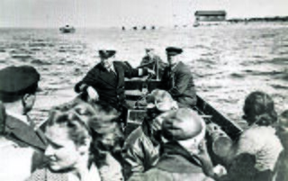
Artur Toom was an Estonian ornithologist and conservationist who worked on the island of Vilsandi which later became Vilsandi National Park. He was arrested following the Soviet occupation of Estonia and died in Usollag Gulag labor camp.
58°20′49″N21°55′47″E / 58.3469°N 21.9297°E
| | This Saare County location article is a stub. You can help Wikipedia by expanding it. |