
Saare County is one of 15 counties of Estonia. It consists of Saaremaa, the largest island of Estonia, and several smaller islands near it, most notably Muhu, Ruhnu, Abruka and Vilsandi. The county borders Lääne County to the east, Hiiu County to the north, and Latvia to the south. In 2022, Saare County had a population of 31,292, which was 2.4% of the population of Estonia.

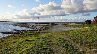
The island of Vilsandi in Saaremaa Parish of Estonia's Saare County is located in the Baltic Sea. It covers an area of some 9 square km and is the westernmost populated island in Estonia. The surrounding waters are shallow and rocky and many ships travelling the Baltic have perished nearby. The island of Vilsandi can be reached by boat, by truck having suitable clearance or on foot by wading from Saaremaa. Much of the island is now part of Vilsandi National Park, which grew from a bird reserve founded in 1910. It is a highly sensitive ecosystem due to the use of the area by many migratory birds as a breeding and nesting ground. Hunting is absolutely prohibited. This park is a popular tourist destination not only for local Estonians, but also people of Finland who are visiting Estonia in greater and greater numbers.
This is a list of the extreme points on land of Estonia: the points that are farther north, south, east or west than any other location.

Kihelkonna Parish was a municipality in Saare County, Estonia.

Vesiloo is a small, uninhabited Estonian island in the Baltic Sea. Its coordinates are 58°23′45″N21°50′35″E.

Nootamaa is a small, uninhabited island in the Baltic Sea belonging to the country of Estonia. It marks the westernmost part of Estonia's territorial boundary.

Loona is a village in Saaremaa Parish, Saare County in western Estonia.
Atla is a village in Saaremaa Parish, Saare County in western Estonia. It is the westernmost settlement of Estonia.
Innarahu is a small, uninhabited Baltic Sea islet belonging to Estonia.
Koerakuiv is a small islet in the Baltic Sea belonging to the country of Estonia. Koerakuiv lies just off the northwest coast of the island of Saaremaa, and is administratively part of Atla village in Saaremaa Parish, Saare County and is also part of Vilsandi National Park.
Püskumadal is a small islet in the Baltic Sea belonging to the country of Estonia. Püskumadal lies just off the northwest coast of the island of Saaremaa, and is administratively part of Atla village in Saaremaa Parish, Saare County and is also part of Vilsandi National Park.
Salavamaa also known as Salava is a small island in the Baltic Sea belonging to the country of Estonia. Salavamaa lies just off the northwest coast of the island of Saaremaa, and is administratively part of Atla village in Saaremaa Parish, Saare County and is also part of Vilsandi National Park.

Urverahu is a small uninhabited islet in the Baltic Sea belonging to the country of Estonia. Urverahu lies just off the northwest coast of the island of Saaremaa, and is administratively part of Atla village in Saaremaa Parish, Saare County and is also part of Vilsandi National Park.
Ooslamaa is a small islet in the Baltic Sea belonging to the country of Estonia.
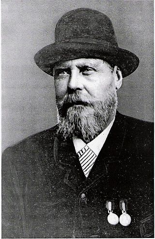
Peeter All was an Estonian fisherman, farmer, ship captain, shipowner, rescuer of mariners in distress, and salvage diver. He is best known for his multifaceted maritime career and contributions to the Estonian maritime industry.
Tõõdilaid is a small Estonian islet within Saastna Bay off the south-east coast of the island of Saaremaa in the Baltic Sea. The island covers 0.0136 hectares and has a perimeter of 0.6 kilometers and lies in an oblong Southwest-Northeast position. Tõõdilaid is administered by Saaremaa Parish, Saare County and is part of the Kahtla-Kübassaare hoiuala Limited-conservation area.
Võrkrahu is a small islet belonging to the country of Estonia off the west coast of the larger island of Saaremaa in the Kuusnõmme Gulf of the Baltic Sea. It is administered by Lääne-Saare Parish. Võrkrahu lies in an oblong north–south direction and is covered in pine and junipers. It covers an area of 6.07618 hectares and a circumference of 1.32628 kilometers and is part of Vilsandi National Park.
Pitkasääremaa is a small islet in the Baltic Sea belonging to the country of Estonia.
Siiasaar is a small islet in the Baltic Sea belonging to the country of Estonia.
Lombimaa is a small islet in the Baltic Sea belonging to the country of Estonia.
