
Fada N'Gourma, also written Fada-Ngourma, or Noungu is a city and an important market town in eastern Burkina Faso, lying 219 kilometres (136 mi) east of Ouagadougou, in the Gourmantché area. It is the capital of the East region and of Gourma province. It is known for its blanket and carpet manufacturing as well as its honey.

Titao is a town located in the province of Loroum in Burkina Faso. It is the capital of Loroum Province.
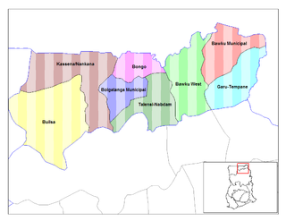
The Bawku Municipality with its administrative capital located at Bawku is one of the 13 MMDAs in the Upper East Region of Ghana. The Municipality was upgraded from the then Bawku District Assembly, through the Local Government (Establishment) Instrument, 1989 .The population of Bawku Municipal, according to the 2010 Population and Housing Census, is 98,538 representing 9.4 percent of the Upper East region‟s total population. Males constitute 48.0 percent and females represent 52.0 percent. 36.4 percent of the population is rural and 63.6 percent is urban. It shares boundaries with Pusiga District to the North, Binduri District to the South, Garu-Tempane District to the East and Bawku West to the West

Komtoèga is a department or commune of Boulgou Province in eastern Burkina Faso. Its capital lies at the town of Komtoèga. According to the 1996 census the department has a total population of 18,917.
Yargo is the name of several villages in Burkina Faso, including the following:
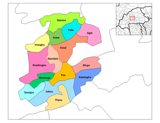
Nanoro is a department or commune of Boulkiemdé Province in central Burkina Faso. As of 2005 it has a population of 33,511. Its capital lies at the town of Nanoro.
Tanlallé is a village in the Kogho Department of Ganzourgou Province in central Burkina Faso. The village has a population of 778.
Ningare is a town in the Tenkodogo Department of Boulgou Province in south-eastern Burkina Faso. As of 2005, the town has a population of 2,160.
Youga is a village in the Zabré Department of Boulgou Province in south-eastern Burkina Faso, about 2 km north from border with Ghana. As of 2005, the village had a population of 1018, but due to discovery of gold in the vicinity and subsequent establishment of Youga Gold Mine, population is growing.
Youkouka is a village in the Zabré Department of Boulgou Province in south-eastern Burkina Faso. As of 2005, the village has a population of 374.
Banidjoari is a village in the Coalla Department of Gnagna Province in eastern Burkina Faso. The village has a population of 829.
Dassari is a village in the Manni Department of Gnagna Province in eastern Burkina Faso. The village has a population of 981.
Komona is a village in the Manni Department of Gnagna Province in eastern Burkina Faso. The village has a population of 246.
Madori is a town in the Manni Department of Gnagna Province in eastern Burkina Faso. The town has a population of 1,577.

Pszczółki Górne is a village in the administrative district of Gmina Grudusk, within Ciechanów County, Masovian Voivodeship, in east-central Poland. It lies approximately 5 kilometres (3 mi) east of Grudusk, 21 km (13 mi) north of Ciechanów, and 95 km (59 mi) north of Warsaw.
The Findlay Group is a group of islands in the Canadian Arctic Archipelago in Qikiqtaaluk Region, Nunavut. This Arctic Ocean group consists of Lougheed Island, Stupart Island, Edmund Walker Island, Grosvenor Island and Patterson Island.
Idzbark is a village in the administrative district of Gmina Ostróda, within Ostróda County, Warmian-Masurian Voivodeship, in northern Poland. It lies approximately 6 kilometres (4 mi) east of Ostróda and 32 km (20 mi) west of the regional capital Olsztyn.
Květnice is a village and municipality in Prague-East District in the Central Bohemian Region of the Czech Republic.
Oela is a village in Rapla Parish, Rapla County in northwestern Estonia.
Thion, Burkina Faso is a town in the Thion Department of Gnagna Province in eastern Burkina Faso. The town has a population of 3030 and it is the capital of the Thion Department.


