Related Research Articles

The Pacific Coast Ranges are the series of mountain ranges that stretch along the West Coast of North America from Alaska south to Northern and Central Mexico. Although they are commonly thought to be the westernmost mountain range of the continental United States and Canada, the geologically distinct Insular Mountains of Vancouver Island lie farther west.

The Sierra Madre Occidental is a major mountain range system of the North American Cordillera, that runs northwest–southeast through northwestern and western Mexico, and along the Gulf of California. The Sierra Madre is part of the American Cordillera, a chain of mountain ranges (cordillera) that consist of an almost continuous sequence that form the western "sounds" of North America, Central America, South America, and West Antarctica.
In geology, a terrane is a crust fragment formed on a tectonic plate and accreted or "sutured" to crust lying on another plate. The crustal block or fragment preserves its distinctive geologic history, which is different from the surrounding areas—hence the term "exotic" terrane. The suture zone between a terrane and the crust it attaches to is usually identifiable as a fault. A sedimentary deposit that buries the contact of the terrane with adjacent rock is called an overlap formation. An igneous intrusion that has intruded and obscured the contact of a terrane with adjacent rock is called a stitching pluton.
Madre de Dios may refer to:
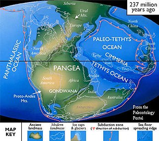
Cimmeria was an ancient continent, or, rather, a string of microcontinents or terranes, that rifted from Gondwana in the Southern Hemisphere and was accreted to Eurasia in the Northern Hemisphere. It consisted of parts of present-day Turkey, Iran, Afghanistan, Pakistan, Tibet, China, Myanmar, Thailand, and Malaysia. Cimmeria rifted from the Gondwanan shores of the Paleo-Tethys Ocean during the Early Permian and as the Neo-Tethys Ocean opened behind it, during the Permian, the Paleo-Tethys closed in front of it. Because the different chunks of Cimmeria drifted northward at different rates, a Meso-Tethys Ocean formed between the different fragments during the Cisuralian. Cimmeria rifted off Gondwana from east to west, from Australia to the eastern Mediterranean. It stretched across several latitudes and spanned a wide range of climatic zones.
Madre de Dios Island is an uninhabited island in the Magallanes Region, Chile. It is located west of the Trinidad Channel and Concepción Channel. Madre de Dios Island is composed partly of limestone and has several natural caves. In one of those caves, called the "Cave of the Whales", skeletons of whales 2600 to 3500 years old have been discovered 10 to 30 meters above sea level. In another cave, named Cueva del Pacifico, rock art was discovered in 2006. Many other caves near the coast were used by the indigenous Kaweskar people for burial. One skull found dates back to 4500 years ago. Some caves were used as temporary camps. The island, along with 53 smaller nearby islands, was protected as a nature reserve in 2007.

Gondwana was a large landmass, sometimes referred to as a supercontinent. The remnants of Gondwana make up around two-thirds of today's continental area, including South America, Africa, Antarctica, Australia, Zealandia, Arabia, and the Indian Subcontinent.
Kazakhstania, the Kazakh terranes, or the Kazakhstan Block, is a geological region in Central Asia which consists of the area roughly centered on Lake Balkhash, north and east of the Aral Sea, south of the Siberian craton and west of the Altai Mountains. The Junggar basin in Xinjiang, China, is also part of Kazakhstania, though sometimes referred to as the Junggar Block. Because the Kazakh terranes merged during the Late Ordovician as part of the Central Asian Orogenic Belt they are also referred to as the Kazakh Orogen. These terranes are located in what is today Kazakhstan, north-eastern Uzbekistan, northern Kyrgyzstan and south-western China. Today Kazakhstania is surrounded by three large, former continents: to the north-east the Gornostaev Shear Zone separates it from Siberia with which it collided during the Carboniferous; to the north-west is Baltica which lay adjacent to the Kazakh Tourgai terrane but far away from Kazakhstania; to the south and east was Gondwana stretching from the South Pole to the Equator. Not far away from the dispersed Kazakh terranes were South China, North China, and Tarim, but how these continental blocks were positioned relative to Gondwana is not known.
This is a list of articles related to plate tectonics and tectonic plates.

The Cañadón Asfalto Formation is a geological formation from the Lower Jurassic, with doubtful layers of Late Jurassic age previously referred to it. The Cañadón Asfalto Formation is located in the Cañadón Asfalto Basin, a rift basin in the Chubut Province of northwestern Patagonia, southern Argentina. The basin started forming in the earliest Jurassic.

The Armorican terrane, Armorican terrane assemblage, or simply Armorica, was a microcontinent or group of continental fragments that rifted away from Gondwana towards the end of the Silurian and collided with Laurussia towards the end of the Carboniferous during the Variscan orogeny. The name is taken from Armorica, the Gaulish name for a large part of northwestern France that includes Brittany, as this matches closely to the present location of the rock units that form the main part of this terrane.

The geology of Uruguay combines areas of Precambrian-aged shield units with a region of volcanic rock erupted during the Cretaceous and copious sedimentary facies the oldest of which date from the Devonian. Big events that have shaped the geology of Uruguay include the Transamazonian orogeny, the breakup of Rodinia and the opening of the South Atlantic.

The Famatinian orogeny is an orogeny that predates the rise of the Andes and that took place in what is now western South America during the Paleozoic, leading to the formation of the Famatinian orogen also known as the Famatinian belt. The Famatinian orogeny lasted from the Late Cambrian to at least the Late Devonian and possibly the Early Carboniferous, with orogenic activity peaking about 490 to 460 million years ago. The orogeny involved metamorphism and deformation in the crust and the eruption and intrusion of magma along a Famatinian magmatic arc that formed a chain of volcanoes. The igneous rocks of the Famatinian magmatic arc are of calc-alkaline character and include gabbros, tonalites, granodiorites and trondhjemites. The youngest igneous rocks of the arc are granites.
Víctor Alberto Ramos is an Argentine geologist who has contributed to the paleogeography and plate tectonics of South America. He has been a member of the Chilean Academy of Science since 2001 and won in 2013 the Premio México de Ciencia y Tecnología.
Tobífera Formation is a volcano-sedimentary formation of Middle to Late Jurassic age. The formation is crops out in the Magallanes Region in southern Patagonia and Tierra del Fuego of Chile, the Santa Cruz Province of southern Argentina, and in the subsurface of the Malvinas Basin offshore Argentina and the Falkland Islands.

Patagonia comprises the southernmost region of South America, portions of which lie on either side of the Argentina-Chile border. It has traditionally been described as the region south of the Rio, Colorado, although the physiographic border has more recently been moved southward to the Huincul fault. The region's geologic border to the north is composed of the Rio de la Plata craton and several accreted terranes comprising the La Pampa province. The underlying basement rocks of the Patagonian region can be subdivided into two large massifs: the North Patagonian Massif and the Deseado Massif. These massifs are surrounded by sedimentary basins formed in the Mesozoic that underwent subsequent deformation during the Andean orogeny. Patagonia is known for its vast earthquakes and the damage they cause.

The Huincul Fault or Huincul Fault Zone is an east-to-west-oriented, continental-scale fault that extends from the Neuquén Basin eastwards into the Argentine Shelf. To the west, it has been proposed to extend across the Andes to the Chilean Coast Range.
Chaitenia is a distinct fragment of Earth's crust in southern Chile. Rocks of Chaitenia represents an ancient island arc that existed next to Patagonia which became eventually accreted to it. The accretion of Chaitenia to Patagonia occurred in the Devonian period as inferred from an event where rocks were put under pressure, deformed and heated dated to that period. After merging into Patagonia, accretionary complexes developed west of it, meaning Chaitenia constituted a backstop. Chaitenia is not thought to extend beyond the Huincul lineament to the north, beyond which lies the Chilenia terrane.
The Chonide orogeny was a mountain building event in the Triassic, preserved in coastal accretionary complexes in southwestern Chile. The Chonos Metamorphic Complex, Madre de Dios Accretionary Complex and Diego de Almagro Complex all crop out west of the South Patagonian Batholith. Rocks in the Chonos Metamorphic Complex include turbidites as well as meta-chert and mafic schist. Some researchers propose that during the Permian, the supercontinent Gondwana moved rapidly northward leading to the formation of back-arc marginal basins. The closure of the basins then resulted in the orogeny.
The Ellsworth Land Volcanic Group is a geological formation in the Latady Basin, Ellsworth Land, Antarctic Peninsula, with a calculated maximum depositional age of 183.4 ± 1.4 Ma, and a younger age around 177.5 ± 2.2 Ma, covering the Toarcian stage of the Jurassic Period in the Mesozoic Era. This group is made up of volcanoclastic material, with the Mount Poster Formation, composed of silicic ignimbrites, and the Sweeney Formation, consisting of a mix of basaltic and sedimentary facies.
References
- 1 2 Sepúlveda, S.A.; Hervé, F.; Calderón, M.; Lacassie, J.P. (2008). "Petrological and geochemical characteristics of metamorphic and igneous units from the allochthonous Madre de Dios Terrane, Southern Chile". Gondwana Research . 13 (2): 238–249.