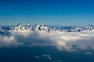
Arunachal Pradesh is a state in northeast India. It was formed from the North-East Frontier Agency (NEFA) region, and India declared it as a state on 20 February 1987. Itanagar is its capital and largest town. It borders the Indian states of Assam and Nagaland to the south. It shares international borders with Bhutan in the west, Myanmar in the east, and a disputed 1,129 km border with China's Tibet Autonomous Region in the north at the McMahon Line. Arunachal Pradesh is claimed in its entirety by China as South Tibet as part of the Tibet Autonomous Region; China occupied some regions of Arunachal Pradesh in 1962 but later withdrew its forces.

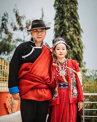
The Monpa (Tibetan: མོན་པ་, Wylie: mon pa, THL: mön pa are a major people of Arunachal Pradesh in northeastern India and one of the 56 officially recognized ethnic groups in China. Most Monpas live in the Indian state of Arunachal Pradesh, with a population of 50,000, centered in the districts of Tawang and West Kameng. As of 2020 there were 11,143 Monpa people living in Le/ Lebo/ Lebugou/ Lebugou township of Cona/ Tsona Tsona City in the southern Tibet Autonomous Region, where they are known as Menba. Of the 45,000 Monpas who live in Arunachal Pradesh, about 20,000 of them live in Tawang district, where they constitute about 97% of the district's population, and almost all of the remainder can be found in the West Kameng district, where they form about 77% of the district's population. A small number of them may be found in bordering areas of East Kameng and Bhutan.

Tawang district is the smallest of the 26 administrative districts of Arunachal Pradesh state in northeastern India. With a population of 49,977, it is the eighth least populous district in the country.

Tawang is a town and administrative headquarter of Tawang district in the Indian state of Arunachal Pradesh. It lies on NH-13 section of Trans-Arunachal Highway. The town was once the headquarter of the Tawang Tract, which is now divided into the Tawang district and the West Kameng district. Tawang continues as the headquarters of the former. Tawang is the number one tourist destination of Arunachal Pradesh.

Hawai is the district headquarters of Anjaw District in the state of Arunachal Pradesh in north-east India.
The Trans-Arunachal Highway (TAH), which includes an existing 1,811 km (1,125 mi) route comprising NH-13 and parts of NH-15, NH-215 and SH-25, is an under-construction 2-lane more than 2,407 km (1,496 mi) long highway passing through 16 districts in Arunachal Pradesh state in India. It runs from LAC in Tawang in northwest to Kanubari in southeast at the tri-junction of Assam-Nagaland-Arunachal Pradesh. It connects at least 16 districts of Arunachal Pradesh.

The Sela Pass is a high-altitude mountain pass located on the border between the Tawang and West Kameng districts in the Indian state of Arunachal Pradesh. It has an elevation of 4170 m (13,700 ft) and connects the Indian Buddhist town of Tawang to Dirang and Guwahati. The pass carries the National Highway 13, connecting Tawang with the rest of India. The pass supports scarce amounts of vegetation and is usually snow-covered to some extent throughout the year. Sela Lake, near the summit of the pass, is one of approximately 101 lakes in the area that are sacred in Tibetan Buddhism. While Sela Pass does get heavy snowfall in winters, it is usually open throughout the year unless landslides or snow require the pass to be shut down temporarily. Sela pass is one of the highest motorable mountain passes in the world

Mechukha or Menchukha is a town, assembly constituency and subdivision, situated 6,000 feet (1,829 m) above sea level in the Mechukha Valley of Yargep Chu/ Siyom River in Shi Yomi district of Arunachal Pradesh state of India. Before the 1950s, Mechuka valley was known as Pachakshiri.

Nuranang Falls, 100 m high waterfall, is located 2 km northeast of the Jang town on the motorable Jang Falls Road in the Tawang district of Arunachal Pradesh state of India. Jang is 40 km southeast of Tawang, north of Sela Tunnel, and between Tawang and Bomdila on NH-13 Trans-Arunachal Highway. Jang Hydal Plant, near the base of fall, is a small hydel plant which generates electricity for local use.

The Takpa or Dakpa language, Dakpakha, known in India as Tawang Monpa, also known as Brami in Bhutan, is an East Bodish language spoken in the Tawang district of Arunachal Pradesh, and in northern Trashigang District in eastern Bhutan, mainly in Kyaleng, Phongmed Gewog, Dangpholeng and Lengkhar near Radi Gewog. Van Driem (2001) describes Takpa as the most divergent of Bhutan's East Bodish languages, though it shares many similarities with Bumthang. SIL reports that Takpa may be a dialect of the Brokpa language and that it been influenced by the Dzala language whereas Brokpa has not.

Pema Khandu is an Indian politician and the Chief Minister of Arunachal Pradesh. He is the son of former Chief Minister of Arunachal Pradesh Dorjee Khandu. Since assuming the office of the Chief Minister in July 2016, he and his government have twice changed their party affiliation; in September from the Indian National Congress to the Peoples Party of Arunachal, and then in December 2016 to the Bharatiya Janata Party. Previously he had served as Minister of Tourism, Urban Development and Water Resources in Nabam Tuki's government.
Arunachal Frontier Highway (AFH), officially notified as the National Highway NH-913 and also called Bomdila-Vijaynagar Highway (BVH), connecting Bomdila Airstrip ALG & HQ in northwest to Vijaynagar Airstrip ALG & HQ in southeast via Nafra HQ-Sarli HQ-Huri Helipad ALG & HQ-Nacho HQ-Mechuka Airstrip ALG & HQ-Monigong HQ-Jido -Hunli HQ-Hayuliang Airstrip ALG HQ-Chenquenty-Hawai HQ-Miao HQ including 800 km greenfield section and network of new tunnels & bridges, is a 2-lane paved-shoulder under-construction national highway along the India-China LAC-McMahon Line border in the Indian state of Arunachal Pradesh. The 1,748 km-long (1,086 mi) highway itself will cost ₹27,000 crore and total cost including 6 additional inter-corridors is ₹40,000 crore. In some places, this highway will run as close as 20 km from the LAC. To be constructed by MoRTH in 9 packages, all packages will be approved by the end of FY 2024-25 and construction will be completed in 2 years by 31 March 2027. Of the total route, 800km is greenfield, rest brownfield will be upgraded and tunnels will be built. This highway in the north & east Arunachal along the China border would complement the Trans-Arunachal Highway and the Arunachal East-West Corridor as major highways spanning the whole state, pursuing the Look East connectivity policy.
Thingbu is a settlement in Tawang district in the north-eastern state of Arunachal Pradesh, India.

Tuting is a town and headquarters of an eponymous circle in the Upper Siang district in Arunachal Pradesh, India. It is situated on the bank of Siang river (Brahmaputra) at a distance of 34 km (21 mi) south of Line of Actual Control and 170 km (110 mi) north of Yingkiong. Tuting is the center of an assembly constituency, and also home to an Indian Military headquarters. The border area reports frequent incursion attempts by the Chinese People's Liberation Army, including an attempt to construct a road in Indian territory.

Vijaynagar is the most remote town and circle headquarters in the Changlang district, Arunachal Pradesh, India.
Hayuliang is a town and the headquarters of an eponymous subdivision in the Anjaw district in the north-eastern state of Arunachal Pradesh, India. It is on the bank of the Lohit River near the confluence of the Delei River.
Kaho is a small village on the banks of the Lohit River on the India-China Line of Actual Control in the Anjaw district in the Indian state of Arunachal Pradesh.

Tawang Chu is the main river of the Tawang district in Arunachal Pradesh, India. The entire district may be regarded as the basin of the Tawang Chu river. In addition, two south-flowing rivers from Tibet, viz., the Tsona Chu and Nyamjang Chu, join the river within the district. The combined river flows west into Bhutan, where it progresses to the Manas River and flows into the Assam state of India.
Jang is a tourist destination, town and subdivision in Jang Valley in Tawang district of Arunachal Pradesh state of India. It lies on NH-13 Trans-Arunachal Highway 40 km southwest of Tawang and north of Sela Tunnel/Sela Pass. As per the 2011 Census of India, Jang has a population of 5,480. Jang Hydal Plant, near the base of Nuranang Falls, is a small hydel plant which generates electricity for local use.


