
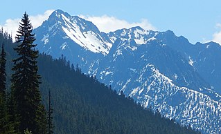
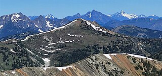
Big Kangaroo is an 8,326-foot (2,538-metre) mountain summit in Okanogan County, Washington, United States.

The Needles is an 8,160-foot (2,487-metre) granite mountain located in Okanogan County in Washington state. It is part of the Okanogan Range which is a sub-range of the North Cascades Range. The Needles is situated on land administered by the Okanogan–Wenatchee National Forest. Precipitation runoff from the peak drains into tributaries of the Methow River. Topographic relief is significant as the summit rises 3,660 feet above Pine Creek in approximately 1.25 mile (2 km). The nearest higher neighbor is Tower Mountain, 2.26 miles (3.64 km) to the southwest.

Azurite Peak is an 8,434-foot (2,571-metre) double-summit mountain located at the common boundary point of Okanogan County, Skagit County, and Whatcom County in Washington state. It is part of the Okanogan Range which is a sub-range of the North Cascades Range. Azurite Peak ranks as the 81st-highest summit in the state. Azurite Peak is situated north of Azurite Pass on land administered by the Okanogan–Wenatchee National Forest. The nearest higher neighbor is Tower Mountain, 5.24 miles (8.43 km) to the south-southeast, and Mount Ballard lies 1.97 miles (3.17 km) to the north. Remnants of a small pocket glacier are found on the east aspect. Precipitation runoff from the peak drains north into tributaries of the Skagit River, and south into the Methow River. Topographic relief is significant as the summit rises over 3,000 feet above Mill Creek in one mile (1.6 km). The Pacific Crest Trail traverses the base of Azurite Peak.
Porcupine Peak is a 7,762-foot-elevation (2,366-meter) mountain located in Skagit County of Washington state.

Mount Ballard is an 8,371-foot (2,551-metre) double-summit mountain located in eastern Whatcom County of Washington state. It is part of the Okanogan Range which is a sub-range of the North Cascades Range, and the mountain is situated on land administered by the Okanogan–Wenatchee National Forest. Ballard ranks 84th on Washington's highest 100 peaks. The nearest higher neighbor is Azurite Peak, 2.04 miles (3.28 km) to the south. Precipitation runoff from Mount Ballard drains into Mill Creek and Slate Creek, both tributaries of the Skagit River. Topographic relief is significant as the summit rises approximately 4,000 feet above Mill Creek in one mile (1.6 km).

Monument Peak is an 8,597-foot (2,620-metre) mountain summit located in western Okanogan County in Washington state. It is part of the Okanogan Range which is a sub-range of the North Cascades. The mountain is situated in the Pasayten Wilderness, on land administered by the Okanogan–Wenatchee National Forest. The nearest higher peak is Mount Lago, 2.42 miles (3.89 km) to the north. Precipitation runoff from Monument Peak drains east into Monument Creek, and west into Eureka Creek, which are both part of the Methow River drainage basin. Topographic relief is significant as the summit rises 3,800 feet above Eureka Creek in 1.25 mile (2 km).
Robinson Mountain is an 8,731-foot (2,661-metre) mountain summit located in western Okanogan County in Washington state. It is part of the Okanogan Range which is a sub-range of the North Cascades Range. The mountain is situated in the Pasayten Wilderness, on land administered by the Okanogan–Wenatchee National Forest. The nearest higher peak is Mount Lago, 7.28 miles (11.72 km) to the north. Precipitation runoff from Robinson Mountain drains west into Robinson Creek, and east into Eureka Creek, which are both part of the Methow River drainage basin. The mountain is named for brothers James and Thomas Robinson who were settlers in the area in the late 1800s.

Cathedral Peak is an 8,606-foot (2,623-metre) mountain summit located in Okanogan County in Washington state. It is part of the Okanogan Range which is a sub-range of the North Cascades. The mountain is situated in the Pasayten Wilderness, on land administered by the Okanogan–Wenatchee National Forest. The nearest higher peak is Grimface Mountain, 2.6 miles (4.2 km) to the north in Cathedral Provincial Park in Canada. The Pacific Northwest Trail traverses below the south slope of Cathedral Peak as it crosses Cathedral Pass. Less than a mile to the opposite side of the pass stands Amphitheater Mountain. Precipitation runoff from Cathedral Peak drains west into Cathedral Fork, or east into Cathedral Creek.

Remmel Mountain, also known as Mount Remmel, is a prominent 8,685-foot (2,647-metre) mountain summit located in Okanogan County in Washington state. It is the highest point in the Cathedral Range, which is a subrange of the Okanogan Range in the North Cascades. The mountain is situated 5 miles (8.0 km) south of the Canada–United States border, on the eastern side of the Cascade crest, in the Pasayten Wilderness, on land managed by the Okanogan–Wenatchee National Forest. The nearest higher peak is Mount Lago, 16.8 miles (27.0 km) to the west-southwest, and Amphitheater Mountain lies 3.6 miles (5.8 km) to the north. Remmel is the third-highest summit of the Okanogan Range following Mount Lago (8,745 ft), and Robinson Mountain (8,726 ft). These three peaks follow Jack Mountain (9,075 ft) as the highest peaks in the Pasayten Wilderness. Remmel is the most prominent mountain in the Pasayten Wilderness. Topographic relief is significant as the summit rises approximately 2,300 feet above Andrews Creek in 0.75 mile (1.2 km). Precipitation runoff from Remmel Mountain drains into the Chewuch River basin.

Apex Mountain is an 8,302-foot (2,530-metre) summit located in Okanogan County in Washington state. It is part of the Okanogan Range which is a sub-range of the North Cascades. The mountain is situated 2.5 miles (4.0 km) south of the Canada–United States border, on the east side of the Cascade crest, in the Pasayten Wilderness, on land managed by the Okanogan–Wenatchee National Forest. The nearest higher peak is Amphitheater Mountain, 2.35 miles (3.78 km) to the west-northwest. The Pacific Northwest Trail traverses the northern slopes of Apex Mountain as it crosses Apex Pass. Precipitation runoff from Apex Mountain drains west into Cathedral Creek, or east into Tungsten Creek, both tributaries of the Chewuch River. Topographic relief is significant as the summit rises 1,200 feet above Tungsten Lake in 0.3 mile (0.5 km).
Mount Lago is a prominent 8,745-foot (2,665-metre) mountain summit located in the Okanogan Range of the North Cascades, in Okanogan County of Washington state. The mountain is situated on the eastern side of the Cascade crest, in the Pasayten Wilderness, on land managed by the Okanogan–Wenatchee National Forest. The nearest higher peak is Jack Mountain, 19.5 miles (31.4 km) to the west-southwest. Mount Lago is the highest summit of the Okanogan Range, and follows only Jack Mountain {9,075 ft} as the highest peak in the Pasayten Wilderness. Lago is the fourth-most prominent mountain in the Pasayten Wilderness. Precipitation runoff from the mountain drains into tributaries of the Pasayten River and Methow River. The mountain was named for Lage Wernstedt (1878–1959), a Forest Service surveyor who made numerous first ascents of the mountains he was mapping in the North Cascades. Lago, is a play on the way Americans pronounced his name. Lage, pronounced Loggy, had a son named Lago.

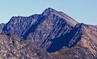
Castle Peak is a prominent 8,343-foot (2,543-metre) mountain summit located in the Hozameen Range of the North Cascades, on the shared border between Okanogan County and Whatcom County of Washington state. The mountain is situated one mile (1.6 km) south of the Canada–United States border, on the Cascade crest, in the Pasayten Wilderness, on land managed by the Okanogan–Wenatchee National Forest. The nearest higher peak is Jack Mountain, 14.8 miles (23.8 km) to the south-southwest. Castle Peak is the second highest summit of the Hozameen Range following Jack Mountain. Castle Peak is the sixth-highest mountain in the Pasayten Wilderness. Precipitation runoff from the mountain drains east into Castle Creek, a tributary of the Similkameen River, or west into tributaries of the Skagit River. Topographic relief is significant as the summit rises nearly 3,000 feet above Crow Creek in 0.75 mile (1.2 km).

Wallaby Peak is a 7,995-foot (2,437-metre) mountain summit located on the boundary line of the Lake Chelan-Sawtooth Wilderness, in Okanogan County, Washington. The mountain is part of the Methow Mountains, which are a subset of the Cascade Range. Wallaby Peak is situated on Kangaroo Ridge which is approximately two miles east and within view of Washington Pass. The nearest higher peak is Big Kangaroo, 0.86 mi (1.38 km) to the north. Precipitation runoff from the peak drains into Early Winters Creek, Cedar Creek, and North Fork Twisp River, all of which are tributaries of the Methow River.

Half Moon is a 7,960+ ft summit located in Okanogan–Wenatchee National Forest, in Okanogan County, of Washington state. The mountain is part of the Methow Mountains, which are a subset of the Cascade Range. Half Moon is situated on Kangaroo Ridge which is approximately two miles east and within view of the North Cascades Highway at Washington Pass. The nearest higher neighbor is Wallaby Peak, 0.23 mi (0.37 km) to the south. Precipitation runoff from the peak drains into Early Winters Creek, and Cedar Creek, both of which are tributaries of the Methow River.

Devils Peak is an 8,081-foot (2,463-metre) mountain summit located in western Okanogan County in Washington state. It is part of the Okanogan Range which is a sub-range of the North Cascades Range. The mountain is situated in the Pasayten Wilderness, on land administered by the Okanogan–Wenatchee National Forest. The nearest higher neighbor is Robinson Mountain, 1.88 miles (3.03 km) to the east-southeast, and Slate Peak is set 3.1 miles (5.0 km) to the west. Precipitation runoff from Devils Peak drains west into Robinson Creek, and east into Eureka Creek, which are both part of the Methow River drainage basin.

Fortune Peak is a 7,382-foot (2,250-metre) mountain summit located along the common border of Kittitas County and Chelan County, in Washington state. Fortune Peak is the second-highest point in the Teanaway area of the Wenatchee Mountains. It is situated 0.74 mi (1.19 km) south-southwest of Ingalls Peak, and southwest of Lake Ingalls, on the Alpine Lakes Wilderness boundary, on land managed by Wenatchee National Forest. Precipitation runoff from the peak drains northwest into Fortune Creek, a tributary of Cle Elum River; south into tributaries of Teanaway River; or east into Ingalls Creek which is part of the Wenatchee River drainage basin. This peak is unofficially named for its position at the head of Fortune Creek. This creek was where the Queen of the Hills and Ruby Mines were located. Queen of the Hills was a lode gold mine, whereas the Ruby Mine produced antimony, copper, lead, and silver with a by-product of gold.
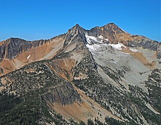
Tatie Peak is a 7,386-foot (2,251-metre) mountain summit located on the shared border between Okanogan County and Whatcom County in Washington state. It is part of the Okanogan Range, which is a sub-range of the North Cascades. The mountain is situated 2.6 miles (4.2 km) east of Mount Ballard, and 3.3 miles (5.3 km) south of Slate Peak, on land managed by the Okanogan–Wenatchee National Forest. The nearest higher neighbor is Syncline Mountain, 0.8 miles (1.3 km) to the south-southwest. The Pacific Crest Trail traverses the south slope of the peak, with an easy off-trail scramble to reach the summit. Precipitation runoff from Tatie Peak drains south into Trout Creek which is a tributary of the Methow River, or northwest into Slate Creek, which is part of the Skagit River drainage basin.

Syncline Mountain is a 7,560-foot (2,300-metre) mountain summit located on the shared border between Okanogan County and Whatcom County in Washington state. It is part of the Okanogan Range, which is a sub-range of the North Cascades, and is situated on land managed by the Okanogan–Wenatchee National Forest. Its nearest neighbor is Tatie Peak, 0.8 miles (1.3 km) to the north, and the nearest higher neighbor is Mount Ballard, 2.1 miles (3.4 km) to the west. The Pacific Crest Trail traverses the east slope of the peak, with an off-trail scramble to reach the summit. Precipitation runoff from Syncline Mountain drains east into Trout Creek which is a tributary of the Methow River, or northwest into Slate Creek, which is part of the Skagit River drainage basin. This unofficially named mountain features a conspicuous syncline, hence its descriptive name.

Cape Horn is a 7,316-foot (2,230-metre) mountain summit located in Chelan County of Washington state. Cape Horn is situated 12 mi (19 km) west-northwest of Leavenworth, within the Alpine Lakes Wilderness, on land managed by the Okanogan–Wenatchee National Forest. Cape Horn is part of the Chiwaukum Mountains, a subset of the Cascade Range. The nearest higher neighbor is Ladies Peak, 0.9 mi (1.4 km) to the northwest, and Grindstone Mountain is set 1.4 mi (2.3 km) to the south. Precipitation runoff from Cape Horn drains west to Icicle Creek, whereas the east slopes drain into Chiwaukum Creek, and both are tributaries of the Wenatchee River. Although modest in elevation, relief is significant since this peak rises over 4,300 feet above Icicle Creek Valley in approximately two miles, and 2,100 feet above the Spanish Camp Creek in one mile. This mountain was named by Albert Hale Sylvester in 1909 for its sharp profile. This mountain's toponym has been officially by the United States Board on Geographic Names.
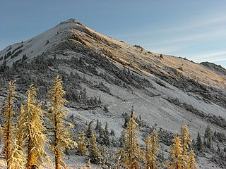
Tamarack Peak is a 7,290-foot (2,222-metre) mountain summit located on the border shared by Okanogan County and Whatcom County in Washington state.


