Maksimir Park is the oldest public park in Zagreb, Croatia. It forms part of the city's cultural heritage and is a habitat for many different plant and animal species.
Founded in 1787, Maksimir Park was the first large public park in South-Eastern Europe, and predates the majority of Europe's public park foundings.[2] The park was opened in 1794[3] under the initiative of the man for whom it was named, Bishop Maksimilijan Vrhovac of Zagreb (1752–1827).[2] At that time, the park was located on the outskirts of the city, while today the city's neighborhoods have largely enveloped it. It was formerly a dense forest of hornbeams (Carpinus betulus) and oaks (Quercus robur and Q.petraea). The remainder of the original forest survives as a girdle to the park, the area in total measuring above 1,005 acres (4.07km2).[2]
Landscaping
The landscaping was first conceived by Bishop Vrhovac in the baroque style.[2] As one of the earliest public parks, it followed the principles laid out by the gardening theorist Christian Cay Lorenz Hirschfeld.[4] In 1839, Bishop Juraj Haulik (1788–1869), and others redesigned the park.[5] Haulik's vision was very much in line with Biedermeierist notions, and romantic neoclassicism, with elements from historicism; and in emulation of the park at the Laxenburg estate of the Habsburgs.
The process of transforming Maksimir Park involved the felling of the forest interior, the grading of hills, the excavating of great holes for lakes, the laying of paths, and construction of bridges.[2]
Schücht's contributions include, among others, Paviljon Jeka (The Pavilion of Echoes), a lookout known as the Kiosk, and a house called Švicarska kuća (The Swiss House).[citation needed]
Design
The park has several big meadows, numerous creeks, and five lakes, and is a habitat for various plant and animal species, such as the Middle Spotted Woodpecker (Dendrocopos medius), an endangered species in Europe.[1]
Zagreb’s Zoo also forms part of the park’s territory, located in the southern part of Maksimir Park.
In addition to the park, the name Maksimir may also refer to one of Zagreb’s neighborhoods and NK Dinamo’s stadium, both of which are adjacent to the park.
Since records began in 1949, the highest temperature recorded at the local weather station at an elevation of 123 metres (404ft) was 40.4°C (104.7°F), on 5 July 1950.[7] The coldest temperature was −31.4°C (−24.5°F), on 15 February 1940.[8]
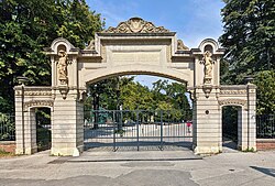
Location and access
Maksimir is located in the eastern central part of the city.
ZET tram lines 4, 5, 7, 11 and 12 frequently connect the park to the rest of the city. A stop named Bukovačka is located at the main entrance into the park.[9]
A less frequent bus route 226 from a nearby Svetice terminal connects to the Mirogoj cemetery and goes on to the Kaptol terminal in the old city centre.[10]
↑ Žmegač, Andrej. "Vrhovčev i Haulikov Maksimir". hrcak.hr. Prostor: znanstveni časopis za arhitekturu i urbanizam, Vol. 10 No. 2(24), 2002. Retrieved 3 February 2024.
This page is based on this Wikipedia article Text is available under the CC BY-SA 4.0 license; additional terms may apply. Images, videos and audio are available under their respective licenses.