Mandoto District | |
|---|---|
 Mandoto district | |
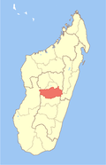
 Mandoto District Location in Madagascar | |
| Coordinates: 19°34′S46°17′E / 19.567°S 46.283°E | |
| Country | |
| Region | Vakinankaratra |
| District | Mandoto |
| Area | |
• Total | 4,500 km2 (1,700 sq mi) |
| Elevation | 817 m (2,680 ft) |
| Population (2018)Region Vakinatra | |
• Total | 227,800 |
| • Ethnicities | Merina |
| Time zone | UTC3 (EAT) |
| Postal code | 113 |
Mandoto is a town, commune and district in Madagascar. It belongs to the Vakinankaratra Region. The population of the district was estimated to be approximately 227,800 in 2018. It was formed by splitting up the district of Betafo.