The following is an overview of the demographics of Myanmar, including statistics such as population, ethnicity, language, education level and religious affiliation.

The Shan are a Tai ethnic group of Southeast Asia. The Shan live primarily in the Shan State of Burma (Myanmar), but also inhabit parts of Mandalay Region, Kachin State, and Kayin State, and in adjacent regions of China, Laos, Assam and Thailand. Though no reliable census has been taken in Burma since 1935, the Shan are estimated to number 4–6 million, with CIA Factbook giving an estimate of five million spread throughout Myanmar.

Sagaing Region is an administrative region of Myanmar, located in the north-western part of the country between latitude 21° 30' north and longitude 94° 97' east. It is bordered by India’s Nagaland, Manipur, and Arunachal Pradesh States to the north, Kachin State, Shan State, and Mandalay Region to the east, Mandalay Region and Magway Region to the south, with the Ayeyarwady River forming a greater part of its eastern and also southern boundary, and Chin State and India to the west. The region has an area of 93,527 km2. In 1996, it had a population of over 5,300,000 while its population in 2012 was 6,600,000. The urban population in 2012 was 1,230,000 and the rural population was 5,360,000. The capital is Sagaing.

Kayah State is a state of Myanmar. Situated in eastern Myanmar, it is bounded on the north by Shan State, on the east by Thailand's Mae Hong Son Province, and on the south and west by Kayin State. It lies approximately between 18° 30′ and 19° 55′ north latitude and between 96° 50′ and 97° 50′ east longitude. The area is 11,670 km2 (4,510 sq mi). Its capital is Loikaw. The estimated population in 1998 was approximately 207,357, according to UNICEF. It is inhabited primarily by the Karenni ethnic group, also known as Red Karen or Kayah, a Sino-Tibetan people.

Myanmar is divided into twenty-one administrative subdivisions, which include:

Lashio is the largest town in northern Shan State, Myanmar, about 200 kilometres (120 mi) north-east of Mandalay. It is situated on a low mountain spur overlooking the valley of the Yaw River. Loi Leng, the highest mountain of the Shan Hills, is located 45 km (28 mi) to the south-east of Lashio.
Not to be confused with Banmauk

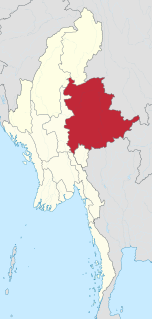
Taunggyi is the capital and largest city of Shan State, Myanmar (Burma) and lies on the Thazi-Kyaingtong road at an elevation of 4,712 feet, just north of Shwenyaung and Inle Lake within the Myelat region. Taunggyi is the fifth largest city of Myanmar, and has an estimated population of 380,665 as of 2014.The city is famous for its hot air balloon festival held annually on the full moon day of Tazaungmon.

Mandalay Region is an administrative division of Myanmar. It is located in the center of the country, bordering Sagaing Region and Magway Region to the west, Shan State to the east, and Bago Region and Kayin State to the south. The regional capital is Mandalay. In the south of the division lies the national capital of Nay Pyi Taw. The division consists of seven districts, which are subdivided into 30 townships and 2,320 wards and village-tracts.

Pinlaung Township is a township of Taunggyi District in the Shan State of Myanmar. It is one of three townships in the Pa-O Self-Administered Zone. Its principal town is Pinlaung. According to the 2014 Myanmar Population and Housing Census, there are 115,047 residents in the township.

Chinshwehaw is a town in Laukkaing Township, Laukkaing District, Shan State of Myanmar.

The Danu Self-Administered Zone, as stipulated by the 2008 Constitution of Myanmar, is a self-administered zone consisting of two townships in Shan State:
The Palaung Self-Administered Zone is a self-administered zone consisting of two townships in Shan State:
The Kokang Self-Administered Zone, as stipulated by the 2008 Constitution of Myanmar, is a self-administered zone in northern Shan State.
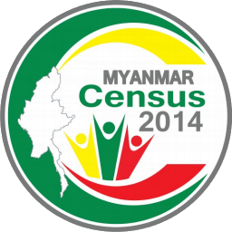
Myanmar Census 2014 was a nationwide census that took place between 30 March and 10 April 2014 in Myanmar (Burma). The census used 100,000 school teachers as census takers, and counted the population as of 29 March 2014 at 24:00 hours (midnight). The theme of the census campaign was A nationwide census – Let us all Participate.
Mong Ko, sometimes spelled Mongko or Monekoe and also known as Man Kan, Man Guo and Panglong, is a town in Mu Se Township, Mu Se District, northern Shan State.
Konkyan is a town in Konkyan Township, Shan State of Myanmar. It is also a part of Kokang Self-Administered Zone.

Pang Hseng, also known as Pan Saing, Kyu Koke and Kyu-hkök, is a town in Mu Se Township, Mu Se District, northern Shan State, Myanmar.
Manhero or Manhlyoe is a town located within Muse Township, Muse District, Shan State, Myanmar.