Mayview, Missouri

Last updated

Mayview, Missouri
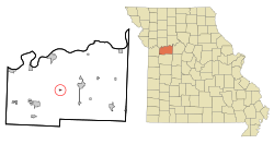
Lafayette County Missouri Incorporated and Unincorporated areas Mayview Highlighted.svg
Location of Mayview, Missouri
Coordinates: 39°03′10″N93°50′00″W / 39.05278°N 93.83333°W / 39.05278; -93.83333
Country United States
State Missouri
County Lafayette
Area
[1]
  Total0.16 sq mi (0.41 km2)
  Land0.16 sq mi (0.41 km2)
  Water0.00 sq mi (0.00 km2)
Elevation
[2]
886 ft (270 m)
Population
 (2020)
  Total208
  Density1,333.33/sq mi (513.43/km2)
Time zone UTC-6 (Central (CST))
  Summer (DST) UTC-5 (CDT)
ZIP code
64071
Area code 660
FIPS code 29-46964 [3]
GNIS feature ID2395056 [2]

Mayview is a city in Lafayette County, Missouri, and part of the Kansas City metropolitan area within the United States. The population was 211 at the 2010 census.

Contents

History

Mayview was platted in 1866. [4] The city was named for its scenic landscape, "when viewed on a May day". [5] A post office called Mayview has been in operation since 1865. [6]

Geography

According to the United States Census Bureau, the city has a total area of 0.16 square miles (0.41 km2), all land. [7]

Demographics

Historical population
CensusPop.Note
1900 423
1910 308−27.2%
1920 40631.8%
1930 322−20.7%
1940 3250.9%
1950 268−17.5%
1960 2700.7%
1970 33022.2%
1980 291−11.8%
1990 279−4.1%
2000 2945.4%
2010 212−27.9%
2020 208−1.9%
U.S. Decennial Census [8]

2010 census

At the 2010 census there were 211 people in 80 households, including 58 families, in the city. The population density was 1,325.0 inhabitants per square mile (511.6/km2). There were 92 housing units at an average density of 575.0 per square mile (222.0/km2). The racial makup of the city was 89.6% White, 7.5% African American, 0.5% Asian, 0.9% from other races, and 1.4% from two or more races. Hispanic or Latino of any race were 0.9%. [9]

Of the 80 households, 35.0% had children under the age of 18 living with them, 52.5% were married couples living together, 15.0% had a female householder with no husband present, 5.0% had a male householder with no wife present, and 27.5% were non-families. 22.5% of households were one person, and 7.5% were one person aged 65 or older. The average household size was 2.65 and the average family size was 3.07.

The median age was 37.5 years. 25.9% of residents were under the age of 18; 7.1% were between the ages of 18 and 24; 27.4% were from 25 to 44; 26.9% were from 45 to 64; and 12.7% were 65 or older. The gender makeup of the city was 47.2% male and 52.8% female.

2000 census

At the 2000 census there were 294 people in 100 households, including 82 families, in the city. The population density was 1,885.9 inhabitants per square mile (728.2/km2). There were 111 housing units at an average density of 712.0 per square mile (274.9/km2). The racial makup of the city was 87.41% White, 9.52% African American, 1.02% Native American, and 2.04% from two or more races. Hispanic or Latino of any race were 2.72%. [3]

Of the 100 households, 49.0% had children under the age of 18 living with them, 63.0% were married couples living together, 15.0% had a female householder with no husband present, and 18.0% were non-families. 15.0% of households were one person, and 4.0% were one person aged 65 or older. The average household size was 2.94 and the average family size was 3.29.

In the city the population was spread out, with 33.3% under the age of 18, 6.1% from 18 to 24, 32.7% from 25 to 44, 17.7% from 45 to 64, and 10.2% 65 or older. The median age was 33 years. For every 100 females, there were 88.5 males. For every 100 females age 18 and over, there were 94.1 males.

The median household income was $25,313 and the median family income was $28,750. Males and females had median incomes of $24,063 and $17,875, respectively. The per capita income for the city was $10,784. About 11.4% of families and 14.1% of the population were below the poverty line, including 13.6% of those under the age of eighteen and 21.7% of those 65 or over.
Related Research Articles

<span class="mw-page-title-main">Oldtown, Idaho</span> City in Idaho, United States

Oldtown is a city in Bonner County, Idaho and suburb of Newport, Washington, with a population of 184 at the 2010 census. It is located on the Pend Oreille River, just east of Newport. There are no natural or physical barriers, and it is strictly a political division, separated by the straight-line state boundary. Oldtown is squeezed between this boundary to the west and the river to the east, leaving the main business district on U.S. Route 2 with only 700 feet of space in which to operate on the Idaho side. Many homes are located in the south end on the other side of the railroad, as the Pend Oreille is somewhat further away here.

<span class="mw-page-title-main">Culdesac, Idaho</span> City in Idaho, United States

Culdesac is a city in Nez Perce County, Idaho, United States. The population was 380 at the 2010 census. It is part of the Lewiston, ID-WA Metropolitan Statistical Area.

<span class="mw-page-title-main">Osburn, Idaho</span> City in Shoshone County, Idaho, United States

Osburn is a city in Shoshone County, Idaho, United States. Located in the Silver Valley mining region of northern Idaho, its population was 1,555 at the 2010 census.

<span class="mw-page-title-main">Van Wert, Iowa</span> City in Iowa, United States

Van Wert is a city in northern Decatur County, Iowa, United States. The population was 178 at the time of the 2020 census.

<span class="mw-page-title-main">Macksburg, Iowa</span> City in Iowa, United States

Macksburg is a city in Madison County, Iowa, United States. The population was 97 at the time of the 2020 census. It is part of the Des Moines–West Des Moines Metropolitan Statistical Area.

<span class="mw-page-title-main">Ruthven, Iowa</span> City in Iowa, United States

Ruthven is a city in Palo Alto County, Iowa, United States. The population was 725 at the time of the 2020 census.

<span class="mw-page-title-main">St. Marys, Iowa</span> City in Iowa, United States

St. Marys or Saint Marys is a city in Warren County, Iowa, United States. The population was 108 at the time of the 2020 census.

<span class="mw-page-title-main">Fillmore, Missouri</span> City in Missouri, United States

Fillmore is a city in Andrew County, Missouri, United States. The population was 173 at the 2020 census.

<span class="mw-page-title-main">Mosby, Missouri</span> City in Missouri, United States

Mosby is a city in Clay County, Missouri, United States, along the Fishing River. The population was 101 at the 2020 census. It is part of the Kansas City metropolitan area.

<span class="mw-page-title-main">St. Thomas, Missouri</span> City in Missouri, United States

St. Thomas is a city in Cole County, Missouri, United States. The population was 222 at the 2020 census. It is part of the Jefferson City, Missouri Metropolitan Statistical Area.

<span class="mw-page-title-main">Coffey, Missouri</span> City in Missouri, United States

Coffey is a city in northern Daviess County, Missouri, United States. The population was 151 at the 2020 census.

<span class="mw-page-title-main">New Hampton, Missouri</span> City in Missouri, United States

New Hampton is a city in southwest Harrison County, Missouri, United States. The population was 228 at the 2020 census.

<span class="mw-page-title-main">Weaubleau, Missouri</span> City in Missouri, United States

Weaubleau is a city in Hickory County, Missouri, United States, founded in 1867. The population was 378 at the 2020 census.

<span class="mw-page-title-main">Wheatland, Missouri</span> City in Missouri, United States

Wheatland is a city in Hickory County, Missouri, United States. The population was 277 at the 2020 census.

<span class="mw-page-title-main">Levasy, Missouri</span> City in Missouri, United States

Levasy is a city in Jackson County, Missouri, United States. The population was 83 at the 2010 census. It is part of the Kansas City metropolitan area.

<span class="mw-page-title-main">Winfield, Missouri</span> City in Missouri, United States

Winfield is a city in Lincoln County, Missouri, United States. The population was 1,404 at the 2010 census.

<span class="mw-page-title-main">Tarrants, Missouri</span> Village in Missouri, United States

Tarrants is a village in central Pike County, Missouri, United States. The population was 22 at the 2010 census.

<span class="mw-page-title-main">Wood Heights, Missouri</span> City in Missouri, United States

Wood Heights is a city in western Ray County, Missouri, and part of the Kansas City metropolitan area within the United States. The population was 757 at the 2020 census.

<span class="mw-page-title-main">Olivette, Missouri</span> City in Missouri, United States

Olivette is an inner-ring suburb of St. Louis, located in St. Louis County, Missouri, United States. The population was 8,504 at the 2020 census.

<span class="mw-page-title-main">Milligan, Nebraska</span> Village in Nebraska, United States

Milligan is a village in Fillmore County, Nebraska, United States. The population was 241 at the 2020 census.

References

  1. "ArcGIS REST Services Directory". United States Census Bureau. Retrieved August 28, 2022.
  2. 1 2 U.S. Geological Survey Geographic Names Information System: Mayview, Missouri
  3. 1 2 "U.S. Census website". United States Census Bureau . Retrieved January 31, 2008.
  4. "Lafayette County Place Names, 1928–1945 (archived)". The State Historical Society of Missouri. Archived from the original on June 24, 2016. Retrieved October 25, 2016.{{cite web}}: CS1 maint: bot: original URL status unknown (link)
  5. Eaton, David Wolfe (1916). How Missouri Counties, Towns and Streams Were Named. The State Historical Society of Missouri. pp.  183.
  6. "Post Offices". Jim Forte Postal History. Retrieved October 25, 2016.
  7. "US Gazetteer files 2010". United States Census Bureau. Archived from the original on January 12, 2012. Retrieved July 8, 2012.
  8. "Census of Population and Housing". Census.gov. Retrieved June 4, 2015.
  9. "U.S. Census website". United States Census Bureau . Retrieved July 8, 2012.