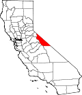
McGee Creek, California | |
---|---|
Coordinates: 37°34′22″N118°47′28″W / 37.57278°N 118.79111°W | |
Country | United States |
State | California |
County | Mono |
Area | |
• Total | 4.01 sq mi (10.38 km2) |
• Land | 4.01 sq mi (10.38 km2) |
• Water | 0 sq mi (0 km2) |
Elevation | 7,701 ft (2,347 m) |
Population (2020) [3] | |
• Total | 45 |
• Density | 11/sq mi (4.3/km2) |
Time zone | UTC-8 (Pacific (PST)) |
• Summer (DST) | UTC-7 (PDT) |
ZIP Code | 93546 (Mammoth Lakes) |
GNIS feature ID | 2583068 [2] |
McGee Creek is an unincorporated community and census-designated place (CDP) in Mono County, California, United States. The community as of the 2020 census the population was 45. [3]
McGee Creek is in southwestern Mono County, sitting at the eastern base of the Sierra Nevada. U.S. Route 395 forms the northeast border of the community, leading northwest 12 miles (19 km) to Mammoth Lakes and southeast 30 miles (48 km) to Bishop. The CDP is named for McGee Creek, which flows out of the Sierra Nevada having risen at the McGee Lakes northeast of Red and White Mountain. McGee Creek Road climbs southwest up the creek valley, ending in 3 miles (5 km) at a trailhead within Inyo National Forest.
According to the United States Census Bureau, the McGee Creek CDP covers an area of 4.0 square miles (10 km2), all of it recorded as land. [1]
The 2010 United States Census [4] reported that McGee Creek had a population of 41. The population density was 10.2 people per square mile (3.9 people/km2). The racial makeup of McGee Creek was 39 (95.1%) White, 0 (0.0%) African American, 0 (0.0%) Native American, 0 (0.0%) Asian, 0 (0.0%) Pacific Islander, 0 (0.0%) from other races, and 2 (4.9%) from two or more races. Hispanic or Latino of any race were 2 persons (4.9%).
The Census reported that 41 people (100% of the population) lived in households, 0 (0%) lived in non-institutionalized group quarters, and 0 (0%) were institutionalized.
There were 21 households, out of which 4 (19.0%) had children under the age of 18 living in them, 8 (38.1%) were opposite-sex married couples living together, 1 (4.8%) had a female householder with no husband present, 1 (4.8%) had a male householder with no wife present. There were 3 (14.3%) unmarried opposite-sex partnerships, and 0 (0%) same-sex married couples or partnerships. 9 households (42.9%) were made up of individuals, and 5 (23.8%) had someone living alone who was 65 years of age or older. The average household size was 1.95. There were 10 families (47.6% of all households); the average family size was 2.50.
The population was spread out, with 7 people (17.1%) under the age of 18, 1 people (2.4%) aged 18 to 24, 6 people (14.6%) aged 25 to 44, 13 people (31.7%) aged 45 to 64, and 14 people (34.1%) who were 65 years of age or older. The median age was 54.8 years. For every 100 females, there were 105.0 males. For every 100 females age 18 and over, there were 126.7 males.
There were 30 housing units at an average density of 7.5 units per square mile (2.9 units/km2), of which 20 (95.2%) were owner-occupied, and 1 (4.8%) were occupied by renters. The homeowner vacancy rate was 0%; the rental vacancy rate was 0%. 40 people (97.6% of the population) lived in owner-occupied housing units and 1 people (2.4%) lived in rental housing units.
Auberry is a census-designated place (CDP) in Fresno County, California, United States. The population was 2,369 at the 2010 census, up from 2,053 at the 2000 census. Auberry is located on Little Sandy Creek 9.5 miles (15 km) west of Shaver Lake Heights, at an elevation of 2,018 feet (615 m).
Cantua Creek is a census-designated place (CDP) in Fresno County, California, United States. As of the 2010 census, the population was 466, down from the 655 reported at the 2000 census. Cantua Creek is located 11 miles (18 km) south-southwest of Tranquillity, at an elevation of 295 feet.
Willow Creek is a census-designated place (CDP) in Humboldt County, California, United States. The population was 1,710 at the 2010 census, down from 1,743 at the 2000 census. Residents of this small mountain town are commonly referred to as "Willow Creekers". The town is located around 30 miles (48 km) from county seat and harbor city Eureka, with the two places differing vastly in climate.
Dixon Lane-Meadow Creek is a census-designated place (CDP) in Inyo County, California, United States. The population was 2,645 at the 2010 census, down from 2,702 at the 2000 census.
Laytonville is a census-designated place (CDP) in Mendocino County, California, United States. It is located 23 miles (37 km) north-northwest of Willits, at an elevation of 1,670 feet (510 m). The population was 1,152 at the 2020 census, down from 1,227 at the 2010 census.
Mono Vista is a census-designated place (CDP) in Tuolumne County, California, United States. The population was 3,127 at the 2010 census, up from 3,072 at the 2000 census.
Loma Mar is a census-designated place (CDP) in San Mateo County, California. It is near San Mateo County Memorial Park on Pescadero Creek Road and is in area code 650. Loma Mar is between the towns of Pescadero and La Honda, situated in the Santa Cruz Mountains in the western part of the San Francisco Peninsula. The United States Postal Service has assigned it ZIP Code 94021. As of the census of 2020, there were 134 residents in the CDP. Loma Mar is home to the YMCA's Camp Loma Mar, Redwood Glen Camp and Conference Center as well as a small number of businesses and services including the Loma Mar Store, a post office, and a fire station run by volunteers.
Coleville is an unincorporated community and census-designated place (CDP) in Mono County, California, United States. It is located at an elevation of 5,141 feet (1,567 m) in the Antelope Valley on the West Walker River. The population was 419 at the 2020 census, down from 495 at the 2010 census.
Swall Meadows is an unincorporated community and census-designated place (CDP) in southern Mono County, California, United States. The population was 178 as of the 2020 census. The community is residential, including second homes and a volunteer fire department, but no commercial development. The ZIP Code is 93514. The community is inside area code 760.
Coffee Creek is a census-designated place located within Trinity County in the U.S. state of California. It is located just north of where Coffee Creek flows into the Trinity River along Highway 3 and is the most northern community in Trinity County. It contains the Coffee Creek elementary school. Coffee Creek Road originates at Highway 3 offering access to the interior of the Trinity Alps; the road is 20 miles long, dirt and only for high clearance vehicles. Coffee Creek sits at an elevation of 2,495 feet (760 m). Its population is 152 as of the 2020 census, down from 217 from the 2010 census.
Clear Creek is a census-designated place (CDP) in Lassen County, California. It is located 2.5 miles (4 km) west-southwest of Westwood, at an elevation of 4970 feet. Its population is 175 as of the 2020 census, up from 169 from the 2010 census.
Bear Creek is a census-designated place in Merced County, California. It is located 3.5 miles (5.6 km) east of Merced, at an elevation of 190 feet. The population was 273 at the 2020 United States census, down from 290 at the 2010 census.
Aspen Springs is an unincorporated community and census-designated place (CDP) in Mono County, California, United States. It lies at an elevation of 7,109 feet (2,167 m). The population was 70 at the 2020 census.
Mono City is an unincorporated community and census-designated place (CDP) in Mono County, California, United States. It lies north of Mono Lake at the base of the Sierra Nevada at the junction of U.S. Route 395 and California State Route 167. The ZIP Code is 93541; mail to Mono City should be addressed Lee Vining. The population was 224 at the 2020 census, up from 172 at the 2010 census.
Topaz is an unincorporated community and census-designated place (CDP) in Mono County, California, United States. It is located 3 miles (5 km) north of Coleville. Topaz's ZIP Code is 96133. The population was 150 at the 2020 census.
Walker is an unincorporated community and census-designated place (CDP) in Mono County, California, United States. It is located 3 miles (5 km) south of Coleville. The ZIP Code is 96107, and mail to Walker should be addressed Coleville.
Paradise is an unincorporated community and census-designated place (CDP) that is the southernmost community in Mono County, California, United States. The population was 174 at the 2020 census.
Butte Creek Canyon is an unincorporated community and census-designated place (CDP) in Butte County, California. Butte Creek Canyon sits at an elevation of 1024 feet in the Sierra Nevada foothills. The 2010 United States census reported Butte Creek Canyon's population was 1,086. In November 2018, the Camp Fire destroyed a large portion of the town.
Lake Don Pedro is a census-designated place (CDP) in Mariposa County, California. The community sits at an elevation of 1,122 feet (342 m). As of the 2020 United States census, the population was 1,765.
Sunny Slopes is an unincorporated community and census-designated place (CDP) in Mono County, California, United States. It sits at an elevation of 7,198 feet (2,194 m). As of the 2020 census, the population was 139, down from 182 in 2010.