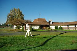
McNulty, Oregon | |
---|---|
Coordinates: 45°50′24″N122°50′31″W / 45.84°N 122.842°W Coordinates: 45°50′24″N122°50′31″W / 45.84°N 122.842°W | |
Country | United States |
State | Oregon |
County | Columbia |
Elevation | 115 ft (35 m) |
Time zone | UTC-8 (Pacific (PST)) |
• Summer (DST) | UTC-7 (PDT) |
ZIP code | 97053 |
Area code(s) | 503 and 971 |
McNulty is an unincorporated community in Columbia County, Oregon, United States. [1] It was named for Columbia River steamboat captain John McNulty, a pioneer riverboatman of the Pacific Northwest. [2]
Oregon Geographic Names is a compilation of the origin and meaning of place names in the U.S. state of Oregon, published by the Oregon Historical Society. The book was originally published in 1928. It was compiled and edited by Lewis A. McArthur. As of 2011, the book is in its seventh edition, which was compiled and edited by Lewis L. McArthur.
Sauvie Island, in the U.S. state of Oregon, originally Wapato Island or Wappatoo Island, is the largest island along the Columbia River, at 26,000 acres (10,522 ha), and one of the largest river islands in the United States. It lies approximately ten miles northwest of downtown Portland, between the Columbia River to the east, the Multnomah Channel to the west, and the Willamette River to the south. A large portion of the island is designated as the Sauvie Island Wildlife Area. Sturgeon Lake, in the north central part of the island, is the most prominent water feature. The land area is 32.75 square miles (84.8 km2), or 20,959 acres (8,482 ha). Most of the island is in Multnomah County, but the northern third is in Columbia County. The Sauvie Island Bridge provides access across the Multnomah Channel from U.S. Route 30 and was completed in June 2008, replacing the first bridge to connect the island to the mainland which was opened on 30 December 1950.
Rooster Rock State Park is a state park located east of Corbett, in the U.S. state of Oregon. One of the features of the park is Rooster Rock, a column of basalt forming a natural obelisk, which stands near the south side of the Columbia River Gorge, in the lee of Crown Point. The park is administered by the Oregon Parks and Recreation Department.
Shepperd's Dell is a small canyon in the Columbia River Gorge in Oregon, located at 45.54833°N 122.195°W which is less than one-third mile southeast of Rooster Rock State Park. The Shepperd's Dell Bridge is listed on the National Register of Historic Places.
Pittsburg is an unincorporated community in Columbia County, Oregon, United States. Pittsburg is located on the Nehalem River near its confluence with the East Fork Nehalem River. The Scappose-Vernonia road and the St. Helens-Pittsburg road join Oregon Route 47 near Pittsburg. Pittsburg's elevation is 584 feet (178 m).
Svensen is an unincorporated community and census-designated place (CDP) on the Columbia River in Clatsop County, Oregon, United States, named after early settler Peter Svensen. There was a post office in Svensen from 1895 to 1944. Since the closure of the Svensen Post Office, mail service has been provided by rural carriers of the Astoria, Oregon post office. Svensen is within the Knappa School District.
Knappa is an unincorporated community and census-designated place located on the south bank of the Columbia River in Clatsop County, Oregon, United States, approximately 12 miles (19 km) directly east of Astoria. Knappa faces the Columbia River, where several islands comprise the Lewis and Clark National Wildlife Refuge.
Ordnance is a ghost town in Umatilla County, Oregon, United States, southwest of Hermiston on Interstate 84/U.S. Route 30, near the intersection with Interstate 82. In 1941, the United States Department of War commissioned the establishment of Umatilla Ordnance Depot in northern Umatilla County; it was later renamed Umatilla Army Depot and then Umatilla Chemical Depot. The town was named after the depot, and Ordnance post office was established in 1943. By the 1960s, Ordnance was no longer a community.
Corbett is an unincorporated community on the Columbia River in eastern Multnomah County, Oregon, United States. It is located on the Historic Columbia River Highway between the Sandy River and Crown Point.
Bridgeton is a compact neighborhood of detached houses, rowhouses, apartment and condominium complexes, and houseboats in the north and northeast sections of Portland, Oregon. It occupies a narrow strip of land around a levee between the Columbia River and Bridgeton Slough.
McNulty is an ancient Gaelic-Irish surname, meaning "son of the Ulsterman". Usually considered a branch of the Ulaid ruling dynasty of Mac Duinnshléibhe (MacDonlevy) who fled Ulaid to Ailech after the former's conquest in 1177 by the Normans, DNA analysis points to descent from other Ulaid families as well. After the Battle of Kinsale in 1602, some McDonlevys and McNultys migrated to the province of Connacht where their name is now common.
Lewis Ankeny McArthur, known as "Tam" McArthur, was an executive for Pacific Power and Light Company. He was also the secretary for the Oregon Geographic Board for many years and the author of Oregon Geographic Names. His book, now in its seventh edition, is a comprehensive source of information on the origins and history of Oregon place names. It is a standard reference book in libraries throughout Oregon and the Pacific Northwest. Tam McArthur Rim in the Cascade Mountains is named in his honor.
Bonneville is an unincorporated community in Multnomah County, Oregon, United States, on Interstate 84 and the Columbia River. Bonneville is best known as the site of Bonneville Dam. North Bonneville, Washington is across the river.
R. R. Thompson was a large sternwheel steamboat designed in the classic Columbia River style. She was named after Robert R. Thompson, one of the shareholders of the Oregon Steam Navigation Company, the firm that built the vessel.
Warren is an unincorporated community and census-designated place in Columbia County, Oregon, United States, located on U.S. Route 30 north of Scappoose and south of St. Helens on Scappoose Bay of the Columbia River. As of the 2010 census it had a population of 1,787.
Kelley Point Park is a city park in north Portland in the U.S. state of Oregon. Bounded by the Columbia Slough on the south, the Willamette River on the west, and the Columbia River on the north, the park forms the tip of the peninsula at the confluence of the rivers. Marine Terminal 6 of the Port of Portland lies immediately east of the park along the Columbia, while Terminal 5 is along the Willamette slightly south of the Columbia Slough. The park is at 45.6498384°N 122.7637106°W and rises to an elevation of 39 feet (12 m) above sea level. Sauvie Island is west of the park across the Willamette River. Hayden Island is slightly upstream of the park on the Columbia River opposite Marine Terminal 6.
Wyeth is an unincorporated locale in Hood River County, Oregon, United States. It is the site of a campground area in the Columbia River Gorge National Scenic Area off Interstate 84 (I-84).
Kerry is an unincorporated community in Columbia County, Oregon, United States, located about 30 miles east of Astoria. It was founded to extend the Columbia & Nehalem River Railroad and named in 1912 by lumberman Albert S. Kerry. In the 1920s it had about 200 inhabitants. Its post office opened in 1917 and closed in 1938.
Mayger is an unincorporated community in Columbia County, Oregon, United States. Fishing is important to Mayger. It was originally the site of Frenchman Charles Mayger's Mayger Logging Company, which he sold in 1886 to William F. Slaughter. Mayger's post office was established three years later and its first postmaster was Charles Mayger. It closed in 1961. Mayger is served by the Clatskanie, Oregon post office.
John McNulty was a pioneer Columbia River steamboat captain.