
Chendamangalam is a small town and a panchayat in Paravur Taluk, Ernakulam district in the state of Kerala, India.
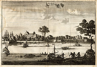
Kodungallur is a historically significant town situated on the banks of river Periyar on the Malabar Coast in Thrissur district of Kerala, India. It is 29 kilometres (18 mi) north of Kochi (Cochin) by National Highway 66 and 38 km (24 mi) from Thrissur. Kodungallur, being a port city at the northern end of the Kerala lagoons, was a strategic entry point for the naval fleets to the extensive Kerala backwaters.
Beypore or Beypur is an ancient port town and a locality town in Kozhikode district in the state of Kerala, India. It is located opposite to Chaliyam, the estuary where the river Chaliyar empties into Arabian Sea. Beypore is part of Kozhikode Municipal Corporation. The place was formerly known as Vaypura / Vadaparappanad and also as Beydary. Tippu Sultan, ruler of Mysore, named the town "Sultan Pattanam". There is a marina and a beach while Beypore port is one of the oldest ports in Kerala, which historically traded with the Middle East. Beypore is noted for building wooden ships, known as dhows or urus in the Malayalam language. These ships were usually bought by Arab merchants for trading and fishing but are now used as tourist ships. According to Captain Iwata, founder member of the Association of Sumerian ships in Japan, Sumerian ships might have been built in Beypore. There is evidence to prove that Beypore had direct trade links with Mesopotamia and was a prominent link on the maritime silk route. The first railway line of Kerala was laid in 1861 from Tirur to Beypore (Chaliyam) passing through Tanur, Parappanangadi, Vallikkunnu, and Kadalundi.
North Paravur. formerly known as Paravur or Paravoor or Parur, is a municipality and suburb in Ernakulam district in the Indian state of Kerala. It is a northern suburb of the city of Kochi and is situated around 20 km from the city centre. It is also the first place in India to use electronic voting machine during the by-elections in 1982.
Azhikode is a coastal village in Thrissur district of Kerala, India. The nearest towns are Kodungallur and Paravoor. Azikode is a part of Kodungallur taluk. Azhikode has a beach known as the munakkal beach. It has got the vast shore stretch around 3 km along the main beach side. It is the main attraction of this village. The main economic activity is fishing.

Thrissur is one of the 14 districts in the Indian state of Kerala. It is situated in the central part the state. Spanning an area of about 3,032 km2 (1,171 sq mi), Thrissur district is home to over 9% of Kerala's population.
Koyilandy is a municipality and a taluk in Kozhikode district, Kerala on the Malabar Coast. The historical town is located right in the middle of the coast of Kozhikode district, between Kozhikode (Calicut) and Kannur, on National Highway 66.

Chavakkad, formerly Chowghat, is a municipality in the Thrissur district of State of Kerala, India. Chavakkad is noted for its beach and fishing. It lies on National Highway 66 is located about 75 km (47 mi) north of the city of Kochi, 25 km (16 mi) northwest of Thrissur, and 24 km (15 mi) south of Ponnani.
Iriveri is a census town in Kannur district in the Indian state of Kerala.

Kalliasseri is a census town in Kannur district in the Indian state of Kerala. Kalliaseri Panchayat comprises two villages: Kalliasseri and Irinave.
Kottuvally is a census town in Paravoor.It is also a village in Paravur Taluk, Ernakulam district in the Indian state of Kerala. The village is situated in the south of the taluk. The nearest town is North Paravur, 4 km away. The Kottuvally panchayath is spread out on both sides of NH-66 road.

Maradu is a municipality in the Ernakulam district of Kerala, India. Maradu is located 6.1 km (3.8 mi) east of the Kochi city centre, and is a part of the Kochi metropolitan area. Maradu is an inner suburb of Kochi, located immediately south of Vyttila and connected to Thevara in the west by the Kundanoor bypass. National highways NH 85, NH 966 B and NH 66 passes through Maradu and has played a vital role in the development of the area.
Mala is a small town in Thrissur district of Kerala state, India. There is a Jewish synagogue in Mala town. At the moment, it is in ruins. The famous Pambu Mekkattu Mana (temple) is located here and attracts thousands of devotees every year.

The Cheraman Juma Mosque is a mosque in Methala, Kodungallur, Thrissur in the Indian state of Kerala. A legend claims that it was built in 643 CE, which makes it the oldest mosque in the Indian subcontinent which is still in use. It was built on the orders of the successor of Cheraman Perumal, the Chera King of modern-day Kerala. The mosque was constructed in Kerala style with hanging lamps, making the historicity of its date claims more convincing. However, other scholars are more skeptical and dated the structure to the 14th-15th century based on the architectural style.

Thrissur is the administrative capital of Thrissur District, in the central part of Kerala state, India. Thrissur district was formed on 1 July 1949. It is an important cultural centre, and is known as the Cultural Capital of Kerala. It is famous for the Thrissur Pooram festival, one of the most colourful and spectacular temple festival of Kerala. From ancient times, Thrissur has been politically, economically and culturally significant to the Indian subcontinent. It has opened the gates for Arabs, Romans, Portuguese, Dutch and English. According to tradition, Thrissur is where Christianity, Islam and Judaism entered the Indian subcontinent. Local Christian tradition holds that Thomas the Apostle arrived in 52 CE, and Muslim tradition states that Methala is the location of country's first mosque.

Cherukunnu is a census town in Kannur district in the Indian state of Kerala. Cherukunnu town is located on Valapattanam-Pappinisseri-Pazhayangadi main road, situated to the south of the Pazhayangadi in Kannur District in Kerala.
Velom Grama Panchayath is a village in Kozhikode district in the state of Kerala, India.

Vatanappally (Vatanappilly/) is a panchayat and census town in Thrissur district, in the state of Kerala, India.It is a suburb of Thrissur city.
Venkitangu is a Panchayath in Thrissur district in the state of Kerala, India.
Thrissur is a district of Kerala situated in the central part of that state in South India. Spanning an area of about 3,032 km2 (1,171 sq mi), Thrissur district is home to over 9% of Kerala's population.
