Middle LaHave, Nova Scotia

Last updated

Middle LaHave, Nova Scotia
Village
2014 NSSA Raceweek Riverport NS Middle LaHave St Marks.JPG
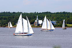
St. Mark's Place behind the 2014 Nova Scotia Schooner Association Race Week course
Canada Nova Scotia location map 2.svg
Red pog.svg
Middle LaHave, Nova Scotia
Location within Nova Scotia
Coordinates: 44°19′16.4″N64°24′29.5″W / 44.321222°N 64.408194°W / 44.321222; -64.408194 Coordinates: 44°19′16.4″N64°24′29.5″W / 44.321222°N 64.408194°W / 44.321222; -64.408194
Country Canada
Province Nova Scotia
Municipality Lunenburg Municipality
Elevation
0 m (0 ft)
Highest elevation
119 m (390 ft)
Lowest elevation
0 m (0 ft)
Time zone UTC-4 (AST)
  Summer (DST) UTC-3 (ADT)
Canadian Postal code
Area code 902
Telephone Exchanges764, 766, 543, 527
NTS Map021A08
GNBC CodeCBFUW
Website www.modl.ca

Middle LaHave is a small village in Nova Scotia, Canada. The community is located in the Lunenburg Municipal District in Lunenburg County.

Contents

Middle LaHave features the narrowest and widest parts of the LaHave River. Which, in the past, made Middle LaHave a major community along the river. The community draws electricity from both the Riverport Electric Light Commission as well as NS Power and also shares both Riverport and Bridgewater telephone exchanges. It has a diverse terrain from low-lying areas to the rolling hills of the Bear Hills area. There are two churches serving the community, being Anglican and United. The third church was closed in 2005, later sold and renovated and officially reopened in 2011 as St. Mark's Place, a privately owned entertainment facility available for community use.

History

Samuel de Champlain struck settlement claims along the banks of both the North and South shores of the river, including Middle LaHave. Traditionally the Northern side of the LaHave is predominantly on the Lighthouse Route, offering a diverse culture, with both French and English backgrounds. Following the colonization by British and French settlers, German families also immigrated to the South Shore, founding Lunenburg in 1753.

Culture

Their culture and traditions are apparent in the area from the dialect to the architecture. Middle LaHave has a wide variety of inhabitants, including traditional and local families such as Crouse, Corkum, Schmeisser, Lohnes and Mosher. The culture of the LaHave and its founding fathers continues to spread throughout Nova Scotia.


Related Research Articles

<span class="mw-page-title-main">Lunenburg, Nova Scotia</span> Coastal town and UNESCO World Heritage Site in Nova Scotia, Canada

Lunenburg is a port town on the South Shore of Nova Scotia, Canada. Founded in 1753, the town was one of the first British attempts to settle Protestants in Nova Scotia.

<span class="mw-page-title-main">Bridgewater, Nova Scotia</span> Town in Nova Scotia, Canada

Bridgewater is a town in Lunenburg County, Nova Scotia, Canada, at the navigable limit of the LaHave River. With a 2021 population of 8,790, Bridgewater is the largest town in the South Shore region.

<span class="mw-page-title-main">Mahone Bay, Nova Scotia</span> Town in Nova Scotia, Canada

Mahone Bay is a town on the northwest shore of Mahone Bay along the South Shore of Nova Scotia in Lunenburg County. A long-standing picturesque tourism destination, the town has recently enjoyed a growing reputation as a haven for entrepreneurs and business startups. The town has the fastest growing population of any municipality in Nova Scotia according to the 2016 census, experiencing 9.9% population growth.

<span class="mw-page-title-main">Kingsburg, Nova Scotia</span> Community in Nova Scotia, Canada

Kingsburg is a village in the province of Nova Scotia, Canada. The community is located approximately 130 kilometres from Halifax.

<span class="mw-page-title-main">Petite Riviere Bridge, Nova Scotia</span>

Petite Rivière is a rural community on Route 331 in Lunenburg County on the South Shore of Nova Scotia in Canada. It was formerly known as Petite Rivière Bridge.

<span class="mw-page-title-main">Riverport, Nova Scotia</span> Community in Nova Scotia, Canada

Riverport is a village in Lunenburg County, Nova Scotia, Canada. The harbour of Ritcey Cove is free from shoals and safe from every wind, considered one of the finest in North America. Riverport is a five-minute drive to several public beaches including Hirtle's Beach, Kingsburg Beach, Oxner Beach, Rose Bay Beach and Spindler Beach.

The Aspotogan Peninsula is a peninsula in the eastern part of Lunenburg County, Nova Scotia, separating St. Margarets Bay in the east from Mahone Bay in the west. The peninsula was originally settled by second generation French immigrants on the east side and by second generation German immigrants on the west side. Traditionally fishing was a major industry for communities throughout the peninsula, however other primary industries such as farming and forestry were historically important as well. Shipping and shipbuilding were secondary and tertiary industries that also came into prominence during the 19th and early 20th centuries.

<span class="mw-page-title-main">South Shore Regional Centre for Education</span> Public school board in Nova Scotia, Canada

The South Shore Regional Centre for Education (SSRCE) is the public school board responsible for the administration of elementary, junior high, and high school education in Lunenburg County and Queens County in Nova Scotia, Canada. The South Shore Regional Centre for Education was established on August 1, 2004 by an Act of the provincial legislature.

The Lighthouse Route is a scenic roadway in the Canadian province of Nova Scotia. It follows the province's South Shore for 585 km (364 mi) from Halifax to Yarmouth.

<span class="mw-page-title-main">Nova Scotia Route 332</span> Highway in Nova Scotia

Route 332 is a collector road in the Canadian province of Nova Scotia. It is located in Lunenburg County, connecting Bridgewater at Trunk 3 with Lunenburg at Trunk 3. It is commonly referred to residences as Riverport Road as the village appears on all major road signage in the county.

<span class="mw-page-title-main">Hubbards, Nova Scotia</span> Place in Nova Scotia, Canada

Hubbards is an unincorporated Canadian rural community on the South Shore of Nova Scotia.

<span class="mw-page-title-main">Municipality of the District of Chester</span> Provides local government to the rural residents in part of Nova Scotia, Canada

The Municipality of the District of Chester is a Nova Scotia district municipality occupying the northeastern half of Lunenburg County, Canada.

<span class="mw-page-title-main">Geography of Nova Scotia</span>

Nova Scotia is a province located in Eastern Canada fronting the Atlantic Ocean. One of the Maritime Provinces, Nova Scotia's geography is complex, despite its relatively small size in comparison to other Canadian provinces.

<span class="mw-page-title-main">LaHave River</span> River in Nova Scotia, Canada

The LaHave River is a 97 km (60 mi) river in Nova Scotia, Canada, running from its source in Annapolis County to the Atlantic Ocean. Along its way, it splits the communities of LaHave and Riverport and runs along the Fairhaven Peninsula and bisects the town of Bridgewater flowing into the LaHave River estuary. Tides affect water levels for about 20 km up the river. There are a number of tourist attractions along the river, and it is also well-used for recreational sailing. As well as two bridges at Bridgewater, the river can be crossed by a cable ferry at the Community of LaHave.

<span class="mw-page-title-main">LaHave, Nova Scotia</span> Community in Nova Scotia, Canada

LaHave is a Canadian community in Lunenburg County, Nova Scotia. The community is located across the river from Riverport and approximately 15 kilometres from the town of Bridgewater. Once the capital of Acadia, it is located on Highway 331 at the mouth of the 97 km long LaHave River.

<span class="mw-page-title-main">Raid on Lunenburg, Nova Scotia (1782)</span> Battle of the American Revolutionary War

The Raid on Lunenburg occurred during the American Revolution when the US privateer, Captain Noah Stoddard of Fairhaven, Massachusetts, and four other privateer vessels attacked the British settlement at Lunenburg, Nova Scotia on July 1, 1782. The raid was the last major privateer attack on a Nova Scotia community during the war.

<span class="mw-page-title-main">Foreign Protestants</span>

The Foreign Protestants were a group of French Lutheran and German Protestant immigrants to Nova Scotia. They largely settled in Halifax at Gottingen Street and Dutch Village Road as well as Lunenburg.

<span class="mw-page-title-main">Southern Nova Scotia</span> Economic Region in Nova Scotia, Canada

Southern Nova Scotia or the South Shore is a region of Nova Scotia, Canada. The area has no formal identity and is variously defined by geographic, county and other political boundaries. Statistics Canada, defines Southern Nova Scotia as an economic region, composed of Lunenburg County, Queens County, Shelburne County, Yarmouth County, and Digby County. According to Statistics Canada, the region had the highest decrease of population in Canada from 2009 to 2010, with a population decrease of 10.2 residents per thousand. The region also has the second-highest median age in Canada at 47.1 years old.