Mount Ann is a 5,840-foot-elevation (1,780-meter) mountain summit located in the North Cascades in Whatcom County of Washington state. It is set within the Mount Baker Wilderness, on land managed by Mount Baker-Snoqualmie National Forest, and is only one mile outside the boundary of North Cascades National Park. Mount Ann is situated immediately southwest of line parentMount Shuksan and northeast of Mount Baker. Mount Ann can be seen south of Artist Point which is at the end of the Mount Baker Highway. Precipitation runoff from the mountain drains into Swift Creek and Shuksan Creek, which empty into Baker Lake. Topographic relief is significant as the west aspect rises 3,200 feet (980 meters) above Swift Creek in approximately one mile. The mountain is unofficially named in association with nearby Lake Ann.[3] Due to its proximity to the Mt. Baker Ski Area, Mount Ann is a winter destination for skiing and snowshoeing.[4]
Mount Ann is located in the marine west coast climate zone of western North America.[5] Most weather fronts originate in the Pacific Ocean, and travel east toward the Cascade Mountains. As fronts approach the North Cascades, they are forced upward by the peaks of the Cascade Range (Orographic lift), causing them to drop their moisture in the form of rain or snowfall onto the Cascades. As a result, the west side of the North Cascades experiences high precipitation, especially during the winter months in the form of snowfall. Mount Ann is situated near the Mt. Baker Ski Area, which recorded the world's greatest snowfall for one season, 1,140 inches (95ft; 29m)), which was recorded during the 1998–1999 season. Because of maritime influence, snow tends to be wet and heavy, resulting in high avalanche danger.[5] During winter months, weather is usually cloudy, but due to high pressure systems over the Pacific Ocean that intensify during summer months, there is often little or no cloud cover during the summer.[5]
Geology
The North Cascades features some of the most rugged topography in the Cascade Range with craggy peaks, ridges, and deep glacial valleys. Geological events occurring many years ago created the diverse topography and drastic elevation changes over the Cascade Range leading to the various climate differences.
During the Pleistocene period dating back over two million years ago, glaciation advancing and retreating repeatedly scoured the landscape leaving deposits of rock debris.[6] The U-shaped cross section of the river valleys is a result of recent glaciation. Uplift and faulting in combination with glaciation have been the dominant processes which have created the tall peaks and deep valleys of the North Cascades area.
Gallery
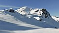
East aspect
Huntoon Point (left) and Mount Ann (centered) from Artist Point
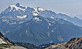
North aspect
Mount Ann centered with Mt. Shuksan behind, left. Camera pointed east.
This page is based on this Wikipedia article Text is available under the CC BY-SA 4.0 license; additional terms may apply. Images, videos and audio are available under their respective licenses.