Mount David (Washington)

Last updated
Mount David
Mt. David.jpg
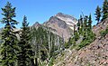
Mt. David centered, from the north
Highest point
Elevation 7,420 ft (2,260 m) [1]
Prominence 2,420 ft (740 m) [1]
Parent peak Kololo Peaks (8,200+ ft) [2]
Isolation 5.69 mi (9.16 km) [2]
Coordinates 47°57′47″N120°59′22″W / 47.96306°N 120.98944°W / 47.96306; -120.98944 [1]
Geography
USA Washington relief location map.jpg
Red triangle with thick white border.svg
Mount David
Location in Washington
Usa edcp relief location map.png
Red triangle with thick white border.svg
Mount David
Location in the United States
CountryUnited States
State Washington
County Chelan
Protected area Glacier Peak Wilderness
Parent range North Cascades
Cascade Range
Topo map USGS Mount David
Geology
Type of rock mica schist, quartzite, breccia [3]
Climbing
Easiest route Hiking trail

Mount David is a prominent 7,420-foot (2,260-metre) mountain summit located in Chelan County of Washington state. [4] The mountain is situated in the Glacier Peak Wilderness, on land managed by the Okanogan-Wenatchee National Forest. Mount David is the highest point of Wenatchee Ridge, a subrange which also includes Indian Head Peak, Whittier Peak, Mount Saul, and Mount Jonathan. [1] Its nearest higher neighbor is Bandit Peak, 5.69 mi (9.16 km) to the east-northeast. [1] Precipitation runoff from Mount David drains into tributaries of the White River. Although modest in elevation, relief is significant since Mt. David rises 5,100 feet above the White River Valley in two miles. This peak was named for the biblical David by Albert Hale Sylvester, a pioneer surveyor, explorer, topographer, and forest supervisor in the Cascades who named thousands of natural features. [3] This mountain can be climbed via the strenuous seven-mile Mount David Trail with over 5,000 feet of elevation gain.

Contents

Geology

Southeast aspect from the trail Mt David, se aspect.jpg
Southeast aspect from the trail

The North Cascades feature some of the most rugged topography in the Cascade Range with craggy peaks, spires, ridges, and deep glacial valleys. Geological events occurring many years ago created the diverse topography and drastic elevation changes over the Cascade Range leading to the various climate differences.

The history of the formation of the Cascade Mountains dates back millions of years ago to the late Eocene Epoch. [5] With the North American Plate overriding the Pacific Plate, episodes of volcanic igneous activity persisted. [5] Glacier Peak, a stratovolcano that is 11.8 mi (19.0 km) north of Mount David, began forming in the mid-Pleistocene. [3] Due to Glacier Peak's proximity to Mount David, volcanic ash is common in the area. In addition, small fragments of the oceanic and continental lithosphere called terranes created the North Cascades about 50 million years ago. [5]

During the Pleistocene period dating back over two million years ago, glaciation advancing and retreating repeatedly scoured and shaped the landscape. [5] Uplift and faulting in combination with glaciation have been the dominant processes which have created the tall peaks and deep valleys of the North Cascades area.

Climate

Mount David (left) and Mt. Jonathan (right) are named for the biblical David and Jonathan. Mts. David and Jonathan.jpg
Mount David (left) and Mt. Jonathan (right) are named for the biblical David and Jonathan.

Weather fronts originating in the Pacific Ocean travel east toward the Cascade Mountains. As fronts approach, they are forced upward by the peaks (orographic lift), causing them to drop their moisture in the form of rain or snowfall onto the Cascades. As a result, the Cascades experience high precipitation, especially during the winter months in the form of snowfall. During winter months, weather is usually cloudy, but, due to high pressure systems over the Pacific Ocean that intensify during summer months, there is often little or no cloud cover during the summer. [3] The months July through September offer the most favorable weather for viewing or climbing this peak.

See also

Related Research Articles

<span class="mw-page-title-main">Sinister Peak</span> Mountain in Washington (state), United States

Sinister Peak is in Mount Baker-Snoqualmie and Wenatchee National Forests in the U.S. state of Washington. It is situated in Glacier Peak Wilderness and the North Cascades. Not quite 1 mi (1.6 km) east of Dome Peak, Sinister Peak is along a high ridge connecting the two peaks. The Chickamin Glacier is on the north slopes of Sinister Peak while the Garden Glacier is just southeast. Though some of the routes to the summit are technical, it can be reached by a moderate scramble.

<span class="mw-page-title-main">Sentinel Peak (Washington)</span> Mountain in Washington (state), United States

Sentinel Peak is a 8,266-foot (2,519-metre) mountain located in the Glacier Peak Wilderness of Washington's North Cascades. The summit is part of the Ptarmigan Traverse. The mountain is situated on the crest of the Cascade Range, on the shared border of Snohomish County and Chelan County, also straddling the boundary between the Mount Baker-Snoqualmie National Forest and the Wenatchee National Forest. The South Cascade Glacier lies below its western slope, and the LeConte Glacier lies on the northeast slope. Its nearest higher peak is Spire Point, 3.03 mi (4.88 km) to the south-southwest.

<span class="mw-page-title-main">Fortress Mountain (Washington)</span> Mountain in Washington, U.S.A.

Fortress Mountain is an 8,679-foot (2,645 m) peak in the Cascade Range located about 15 miles (24 km) west of Lake Chelan in Chelan/Snohomish Counties, Washington, United States. It straddles the border between the Mount Baker-Snoqualmie National Forest and the Wenatchee National Forest, and is also part of the Glacier Peak Wilderness. Fortress Mountain is the highest point on Chiwawa Ridge, and other notable peaks on this ridge include Napeequa Peak, Buck Mountain, Brahma Peak, Bandit Peak, Mount Berge, Helmet Butte, and Chiwawa Mountain.

<span class="mw-page-title-main">Indian Head Peak</span> Mountain in Washington (state), United States

Indian Head Peak is a prominent 7,448-foot (2,270-metre) mountain summit located in the Glacier Peak Wilderness, in the North Cascades of Washington state. The mountain is situated in Chelan County, on land managed by the Okanogan–Wenatchee National Forest. Its nearest higher neighbor is Kololo Peaks, 3.29 mi (5.29 km) to the north. Indian Head Peak is the second-highest point on Wenatchee Ridge, a subrange which also includes Mount Saul, Whittier Peak, and Mount David. Precipitation runoff from the peak drains into Indian Creek and White River which are tributaries of the Wenatchee River.

Kololo Peaks is an 8,200+ ft mountain located in the Glacier Peak Wilderness of the North Cascades in Washington state. The mountain is situated on the crest of the Cascade Range, on the shared border of Snohomish County and Chelan County, and also straddling the boundary between Mount Baker-Snoqualmie National Forest and Wenatchee National Forest. The nearest higher peak is Glacier Peak, 3.29 mi (5.29 km) to the north. Precipitation runoff and meltwater from the White River Glacier on the southeast slope drains into White River. On the west slope, the White Chuck Glacier drains into the White Chuck River, and the Suiattle Glacier and Honeycomb Glacier on the north and east sides drain into the Suiattle River. Surrounded by these glaciers, Fred Beckey in his Cascade Alpine Guide describes the mountain as being almost a nunatak.

<span class="mw-page-title-main">Whittier Peak</span> Mountain in Washington (state), United States

Whittier Peak is a 7,281-foot (2,219-metre) mountain summit located in the Glacier Peak Wilderness of the North Cascades in Washington state. The mountain is situated in Chelan County, in the Wenatchee National Forest. Its nearest higher neighbor is Mount David, 2.26 mi (3.64 km) to the northeast, and Indian Head Peak is 5.2 mi (8.4 km) to the northwest. Precipitation runoff from Whittier Peak drains into tributaries of the Wenatchee River. The peak was named for poet John Greenleaf Whittier by Albert Hale Sylvester, pioneer surveyor, explorer, topographer, and forest supervisor in the Cascades who named thousands of natural features. Other peaks in the immediate vicinity named by Sylvester after poets include Irving Peak, Poe Mountain, Longfellow Mountain, and Bryant Peak.

<span class="mw-page-title-main">White Mountain (Washington)</span> Mountain in Washington (state), United States

White Mountain is a 7,043-foot (2,147-metre) mountain located in the Glacier Peak Wilderness of the North Cascades in Washington state. The mountain is situated on the crest of the Cascade Range, on the shared border of Snohomish County and Chelan County, and also straddling the boundary between Mount Baker-Snoqualmie National Forest and Wenatchee National Forest. White Mountain is located 3.04 mi (4.89 km) to the west-southwest of Kololo Peaks, and immediately north of White Pass. The Pacific Crest Trail traverses the south slope of the peak. Precipitation runoff from the peak drains into the White River, White Chuck River, and Sauk River. The mountain's name was suggested by The Mountaineers, and officially adopted in 1918 by the United States Board on Geographic Names.

<span class="mw-page-title-main">Luahna Peak</span> Mountain in Washington (state), United States

Luahna Peak is an 8,445-foot (2,574-metre) double summit mountain located in the Glacier Peak Wilderness of the North Cascades in Washington state. The true summit is 8,445 feet in elevation, and the northwest subpeak is 8,369 feet. The mountain is situated in Chelan County, in the Wenatchee National Forest. Luahna Peak is the second highest in the Dakobed Range after Clark Mountain which is 1.04 mi (1.67 km) to the southeast, and Luahna lies 6.95 mi (11.18 km) southeast of Glacier Peak. The Richardson Glacier lies to the southeast of the summit, with the Pilz Glacier and Butterfly Glacier stretching across the northern slope. Precipitation runoff from the peak drains into the White River and Napeequa River, both tributaries of the Wenatchee River. The first ascent of the summit was made on August 13, 1911, by Rodney Glisan, H.H. Prouty, Winthrop Stone, C.W. Whittlesey, all of whom were members of the Mazamas.

<span class="mw-page-title-main">Napeequa Peak</span> Mountain in Washington (state), United States

Napeequa Peak is an 8,073-foot (2,461-metre) pyramidal mountain summit located in the Glacier Peak Wilderness of the North Cascades in Washington state. The mountain is situated on the crest of the Cascade Range, on the shared border of Snohomish County and Chelan County, also straddling the boundary between the Mount Baker-Snoqualmie National Forest and the Wenatchee National Forest. Its nearest neighbor is Cirque Mountain, 0.3 mi (0.48 km) to the north, and the nearest higher peak is Buck Mountain, 2.56 mi (4.12 km) to the east-southeast. Precipitation runoff from the peak drains east to the headwaters of Napeequa River; or west into the Suiattle River. The mountain's name is taken from the river's name, which was applied by Albert Hale Sylvester (1871-1944), a pioneer surveyor, explorer, topographer, and forest supervisor in the Cascades.

<span class="mw-page-title-main">Brahma Peak</span> Mountain in Washington (state), United States

Brahma Peak is a remote 8,079-foot (2,462-metre) mountain summit located on Chiwawa Ridge in the North Cascades, in Chelan County of Washington state. The mountain is situated in the Glacier Peak Wilderness, on land managed by the Wenatchee National Forest. The nearest higher neighbor is Buck Mountain, 1.8 mi (2.9 km) to the north. Brahma and Buck are set on Chiwawa Ridge, and other notable peaks on this ridge include Fortress Mountain, Cirque Mountain, Napeequa Peak, Mount Berge, Bandit Peak, and Chiwawa Mountain. Precipitation runoff from Brahma and meltwater from its glacier remnants drains into Chiwawa River and Napeequa River, both tributaries of the Wenatchee River. Topographic relief is significant since the southwest lavender-colored schist cliffs of this peak rise nearly 4,000 feet above the Napeequa River Valley in approximately one mile.

<span class="mw-page-title-main">Cirque Mountain (Washington)</span> Mountain in Washington (state), United States

Cirque Mountain is a 7,966-foot (2,428-metre) mountain summit located in the Glacier Peak Wilderness of the North Cascades in Washington state. The mountain is situated on the crest of the Cascade Range, on the shared border of Snohomish County and Chelan County, also straddling the boundary between the Mount Baker-Snoqualmie National Forest and the Wenatchee National Forest. Its nearest higher peak is Napeequa Peak, 0.3 mi (0.48 km) to the south. The peak is set on Chiwawa Ridge with Napeequa, and other notable peaks on this ridge include Fortress Mountain, Buck Mountain, Brahma Peak, Mount Berge, and Chiwawa Mountain. Topographic relief is significant since the western aspect of the mountain rises 4,000 feet above the Suiattle Valley in approximately 1.5 mi (2.4 km). This mountain has small, unnamed, hanging glaciers in cirques surrounding the summit. Precipitation runoff from the peak and meltwater from the glaciers drains east to the headwaters of Napeequa River; or west into the Suiattle River.

<span class="mw-page-title-main">Tenpeak Mountain</span> Mountain in Washington (state), United States

Tenpeak Mountain is an 8,312-foot (2,533-metre) mountain summit located in the Glacier Peak Wilderness of the North Cascades in Washington state. Tenpeak is situated on the crest of the Cascade Range, on the shared border of Snohomish County and Chelan County, also straddling the boundary between the Mount Baker-Snoqualmie National Forest and the Wenatchee National Forest. Its nearest higher neighbor is Luahna Peak, 2.5 mi (4.0 km) to the southeast. Topographic relief is significant since the northern aspect of the mountain rises 4,200 feet above the Suiattle Valley in approximately 1.5 mi (2.4 km). This mountain has small, unnamed, hanging glaciers in cirques surrounding the summit, and the terminus of the Honeycomb Glacier lies below the western base of the mountain. Precipitation runoff from the mountain and meltwater from the glaciers drains south into White River; or north into the Suiattle River. This mountain's descriptive name was suggested by The Mountaineers, and was officially adopted in 1918 by the U.S. Board on Geographic Names. The first ascent was made September 21, 1940, by Lloyd Anderson and Tom Campbell.

<span class="mw-page-title-main">Mount Berge</span> Mountain in Washington (state), United States

Mount Berge is a 7,951-foot (2,423-metre) double-summit granitic mountain located in the Glacier Peak Wilderness of the North Cascades, in Chelan County of Washington state. The mountain is situated along the crest of the Cascade Range, on land managed by the Okanogan–Wenatchee National Forest. Its nearest higher neighbor is Napeequa Peak, 1.2 mi (1.9 km) to the west, and Buck Mountain is 1.7 mi (2.7 km) to the east-southeast. Berge is positioned on Chiwawa Ridge with Buck and Napeequa, and other notable peaks on this ridge include Fortress Mountain, Brahma Peak, Cirque Mountain, Helmet Butte, and Chiwawa Mountain. Precipitation runoff from Berge drains to the headwaters of Napeequa River; or east into tributaries of the Chiwawa River.

<span class="mw-page-title-main">Bandit Peak</span> Mountain in Washington (state), United States

Bandit Peak is a 7,625-foot (2,324-metre) double-summit granitic mountain located in the Glacier Peak Wilderness of the North Cascades, in Chelan County of Washington state. The mountain is situated east of the crest of the Cascade Range, on land managed by the Okanogan–Wenatchee National Forest. Its nearest higher neighbor is Brahma Peak, 5.9 mi (9.5 km) to the north. Bandit Peak is the ninth-highest peak on Chiwawa Ridge, and other notable peaks on this ridge include Mount Berge, Buck Mountain, Cirque Mountain, Napeequa Peak, Helmet Butte, and Chiwawa Mountain. Precipitation runoff from Bandit Peak drains west into Napeequa River; or east into the Chiwawa River.

<span class="mw-page-title-main">Mount Howard (Washington)</span> Mountain in Washington (state), United States

Mount Howard is a prominent 7,063 feet (2,153 m) mountain summit located west of Lake Wenatchee in Chelan County of Washington state. Mount Howard is the highest point of Nason Ridge, and is 1.37 mi (2.20 km) northeast of Rock Mountain, which is second-highest. This peak is set approximately midway between Stevens Pass and Lake Wenatchee, on land managed by the Okanogan–Wenatchee National Forest. Precipitation runoff from the peak drains into tributaries of the Wenatchee River. The mountain may have been named by a survey party, and first published in 1887.

<span class="mw-page-title-main">Rock Mountain (Washington)</span> Mountain in Washington (state), United States

Rock Mountain is a 6,840+ ft mountain summit located 6.3 mi (10.1 km) northeast of Stevens Pass in Chelan County of Washington state. This peak is situated north of U.S. Highway 2, approximately midway between Stevens Pass and Lake Wenatchee, on land managed by the Okanogan–Wenatchee National Forest. Rock Mountain is the second-highest point on Nason Ridge, following Mount Howard, 1.37 mi (2.20 km) to the northeast. Rock Mountain was named by Albert Hale Sylvester. Precipitation runoff from the peak drains into tributaries of the Wenatchee River.

<span class="mw-page-title-main">Mount Saul</span> Mountain in Washington (state), United States

Mount Saul is a prominent 7,293-foot (2,223-metre) mountain summit located in Chelan County of Washington state. The mountain is situated in the Glacier Peak Wilderness, on land managed by the Okanogan-Wenatchee National Forest. Mount Saul is the fourth-highest point on Wenatchee Ridge, a subrange which also includes Indian Head Peak, Whittier Peak, Mount David, and Mount Jonathan. Its nearest higher neighbor is Mount David, 3.1 mi (5.0 km) to the south-southeast. Precipitation runoff from Mount Saul drains into tributaries of the White River. Although modest in elevation, relief is significant since the south aspect of Mt. Saul rises 4,000 feet above the Indian Creek Valley in a little more than one mile. This peak was named for the biblical Saul because of its gloomy appearance by Albert Hale Sylvester, a pioneer surveyor, explorer, topographer, and forest supervisor in the Cascades who named thousands of natural features.

<span class="mw-page-title-main">Jove Peak</span> Mountain in Washington (state), United States

Jove Peak is a 6,007 ft (1,830 m) mountain summit located 5 mi (8.0 km) north of Stevens Pass on the common border of Snohomish County with Chelan County in Washington state. This peak is situated 12 mi (19 km) west of Lake Wenatchee, in the Henry M. Jackson Wilderness, on land managed by Mount Baker-Snoqualmie National Forest and Okanogan-Wenatchee National Forest. Jove Peak was named by Albert Hale Sylvester for Jove in association with the mythology-theme of nearby Minotaur and Theseus Lakes which are near Labyrinth Mountain, 2.5 mi (4.0 km) to the northeast. Precipitation runoff from the peak drains west into headwaters of Rapid River, or east into Rainy Creek which is a tributary of the Little Wenatchee River.

<span class="mw-page-title-main">Skykomish Peak</span> Mountain in Washington (state), United States

Skykomish Peak is a 6,368-foot (1,941-metre) mountain summit located in the Henry M. Jackson Wilderness in the North Cascades of Washington state. The mountain is situated on the crest of the Cascade Range, on the shared border of Snohomish County with Chelan County, and also straddling the boundary between Mount Baker-Snoqualmie National Forest and Okanogan-Wenatchee National Forest. Skykomish Peak is located 15 mi (24 km) to the north of Stevens Pass, and the Pacific Crest Trail traverses the east slope of this peak. Precipitation runoff from the peak drains west into the Skykomish River, or east into Cady Creek which is a tributary of Little Wenatchee River. This mountain's name derives from its position at the head of the North Fork Skykomish River, and "Skykomish" comes from the Lushootseed word for the Skykomish people, sq̓ixʷəbš, meaning "upriver people".

<span class="mw-page-title-main">Helmet Butte</span> Mountain of Washington (state)

Helmet Butte is a 7,400-foot (2,256-metre) summit located in the Glacier Peak Wilderness of the North Cascades in Washington state.

References

  1. 1 2 3 4 5 "Mount David, Washington". Peakbagger.com.
  2. 1 2 "David, Mount - 7,420' WA". listsofjohn.com. Retrieved 2020-06-27.
  3. 1 2 3 4 Beckey, Fred W. Cascade Alpine Guide, Climbing and High Routes. Seattle, WA: Mountaineers Books, 2008.
  4. "Mount David". Geographic Names Information System . United States Geological Survey, United States Department of the Interior . Retrieved 2020-06-27.
  5. 1 2 3 4 Kruckeberg, Arthur (1991). The Natural History of Puget Sound Country. University of Washington Press.