
Le Flore County is a county along the eastern border of the U.S state of Oklahoma. As of the 2020 census, the population was 48,129. Its county seat is Poteau. The county is part of the Fort Smith metropolitan area and the name honors a Choctaw family named LeFlore. The United States District Court for the Eastern District of Oklahoma is the federal district court with jurisdiction in LeFlore County.
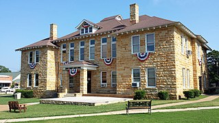
Stone County is located in the Ozark Mountains in the U.S. state of Arkansas. The county is named for rugged, rocky area terrain of the Ozarks. Created as Arkansas's 74th county on April 21, 1873, Stone County has two incorporated cities: Mountain View, the county seat and most populous city, and Fifty-Six. The county is also the site of numerous unincorporated communities and ghost towns.

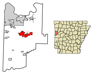
Baxter County is a county in the U.S. state of Arkansas. As of the 2020 census, the county's population was 41,627. The county seat is Mountain Home. It is Arkansas's 66th county, formed on March 24, 1873, and named for Elisha Baxter, the tenth governor of Arkansas.

Mountain Home is a city in and the county seat of Baxter County, Arkansas, United States, in the southern Ozark Mountains near the northern state border with Missouri. As of the 2010 census, the city had a population of 12,448. A total of 41,307 persons lived within the city and micropolitan area combined, which encompasses the majority of Baxter County.
Bentonville is the tenth-largest city in Arkansas, United States and the county seat of Benton County. The city is centrally located in the county with Rogers adjacent to the east. The city is the birthplace of and world headquarters location of Walmart, the world's largest retailer. It is one of the four main cities in the three-county Northwest Arkansas Metropolitan Statistical Area, which is ranked 105th in terms of population in the United States with 546,725 residents in 2020, according to the United States Census Bureau. The city itself had a population of 54,164 at the 2020 Census, an increase of 53% from the 2010 Census. Bentonville is considered to be one of the fastest growing cities in the state and consistently ranks amongst the safest cities in Arkansas. It is included in the Fayetteville–Springdale–Rogers Metropolitan Statistical Area.

Springdale is the fourth-largest city in Arkansas, United States. It is located in both Washington and Benton counties in Northwest Arkansas. Located on the Springfield Plateau deep in the Ozark Mountains, Springdale has long been an important industrial city for the region. In addition to several trucking companies, the city is home to the world headquarters of Tyson Foods, the world's largest meat producing company. Originally named Shiloh, the city changed its name to Springdale when applying for a post office in 1872. It is included in the four-county Northwest Arkansas Metropolitan Statistical Area, which is ranked 102nd in terms of population in the United States with 546,725 in 2020 according to the United States Census Bureau. The city had a population of 84,161 at the 2020 Census.

Yellville is a city in and county seat of Marion County, Arkansas, United States. Yellville is located in the Ozark Mountains along the banks of Crooked Creek, and neighbors the small town of Summit to the north. The population was 1,178 at the 2020 census. The town's original name is preserved in the Shawnee Town Branch, a local creek. The town also holds an annual Turkey Trot Festival.
Greenwood is a city in and one of the two county seats of Sebastian County, Arkansas, United States. It is the fifth largest municipality in the Fort Smith, Arkansas-Oklahoma Metropolitan Statistical Area with a population of 8,952 according to the 2010 US Census. According to estimates based on the most recent census, the population of Greenwood in 2018 was 9,397.

El Dorado, founded by Matthew Rainey, is a city in, and the county seat of, Union County, on the southern border of Arkansas, United States. According to the 2010 census, the population of the city is 18,884.

Fayetteville is the second-most populous city in Arkansas, the county seat of Washington County, and the most populous city in Northwest Arkansas. The city is on the outskirts of the Boston Mountains, deep within the Ozarks. Known as Washington until 1829, the city was named after Fayetteville, Tennessee, from which many of the settlers had come. It was incorporated on November 3, 1836, and was rechartered in 1867. Fayetteville is included in the three-county Northwest Arkansas Metropolitan Statistical Area, which is ranked 100th in terms of population in the United States with 576,403 in 2022 according to the United States Census Bureau. The city had a population of 99,285 in 2022.

Dardanelle is a city in northeast Yell County, Arkansas, United States. The population was 4,745 at the 2010 census. Along with Danville, it serves as a county seat for Yell County. It is located near Lake Dardanelle.

Havana is a city in northwest Yell County, Arkansas, United States. The population was 375 at the 2010 census. It is part of the Russellville Micropolitan Statistical Area. Arkansas Scenic State Highway 309 leads from Havana to the top of Mount Magazine, home of Arkansas's newest State Park, and the highest peak in Arkansas.

Allenspark is an unincorporated town, a post office, and a census-designated place (CDP) located in and governed by Boulder County, Colorado, United States. The CDP is a part of the Boulder, CO Metropolitan Statistical Area. The Allenspark post office has the ZIP code 80510. At the United States Census 2020, the population of the Allenspark CDP was 568.

Cloudcroft is a village in Otero County, New Mexico, United States, and is located within the Lincoln National Forest. The population was 674 at the 2010 census. Despite being located in an otherwise arid region, its high elevation (8,676 feet allows for a mild summer and forested surroundings that makes it a popular tourist attraction in west Texas and southern New Mexico. It was named by Fodor's in 2002 as the Number 3 "Most Overlooked and Underrated Destination Spot." Tourism remains the primary economic driver of the village.
Mount Pocono is a borough in Monroe County, Pennsylvania. It is located nearly centered in the southernmost county of five in the northeastern corner that are part of the Pocono Mountains. The borough serves as a local highway nexus, and sees a lot of tourist traffic making use of resources in the region. As of the 2020 census, the borough population was 3,083 residents.

Branson is a city in the U.S. state of Missouri. Most of the city is situated in Taney County, with a small portion in the west extending into Stone County. Branson is in the Ozark Mountains. The community was named after Reuben Branson, postmaster and operator of a general store in the area in the 1880s. The population was 12,638 at the 2020 census.

Equinox Mountain is the highest peak of the Taconic Range and the second-highest point in southern Vermont, after Stratton Mountain. It rises nearly 3,000 feet above its eastern footings in Manchester, giving Equinox the third-greatest topographic prominence among the state's mountains. A summit observation building is reached via a privately operated toll road, which passes near various towers used for broadcast and other purposes.
Mount Peter is a 1,250-foot (380 m) mountain located in the New York – New Jersey Highlands, Bellvale Mountain, in the U.S. state of New York. The peak is located along the Appalachian Trail in the Town of Warwick, just south of New York State Route 17A, 38 miles (61 km) northwest of New York City, 2 miles (3.2 km) east of Bellvale, New York and north northwest of Greenwood Lake, New York.

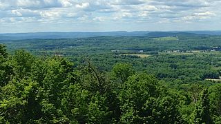
Mount Magazine State Park is a 2,234-acre park located in Logan County, Arkansas. Inhabited since the 1850s, Mount Magazine first became part of the Ouachita National Forest in 1938, was re-designated as part of the Ozark National Forest in 1941, and became a state park after a 22-year conversion process from the U.S. Forest Service to the Arkansas Department of Parks and Tourism. Mount Magazine State Park is the highest in Arkansas. The park contains Mossback Ridge, including the peak of Mount Magazine which contains The Lodge at Mount Magazine, cabins, trails, and a hang gliding area.

Mount Dandenong is a mountain that is part of the Dandenong Ranges of the Great Dividing Range, located in the Central District of Victoria, Australia. The mountain has an elevation of 633 metres (2,077 ft) and is located approximately 45 kilometres (28 mi) east of Melbourne.


