
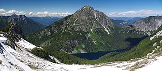
Welch Peak is a 2,431-metre (7,976-foot) mountain summit in the Cheam Range, located in southwestern British Columbia, Canada, near Chilliwack. It is the highest summit in the range. The mountain is named after one of the partners in the engineering firm Foley, Welch and Stewart who built and operated the Lucky Four Mine located near the peak. Nearby peaks are also named after the other partners.

Silvertip Mountain is a 2,596 m (8,517 ft) summit in the Canadian Cascades south of Hope, British Columbia. It lies on the northern boundary of Skagit Valley Provincial Park. With a prominence of 1,871 m (6,138 ft), it is one of the fifty most prominent peaks in Canada. The mountain's toponym was officially adopted on December 2, 1948, by the Geographical Names Board of Canada. The peak was first climbed in 1908 by a Boundary Survey party.

Stewart Peak is a 2,238-metre (7,343-foot) mountain in the Cheam Range, located in southwestern British Columbia, Canada near Chilliwack. It is situated west of The Still Peak and east of Baby Munday Peak. The mountain is named after one of the partners in the engineering firm Foley, Welch and Stewart who built and operated the Lucky Four Mine located near the peak. Nearby peaks are also named after the other partners.

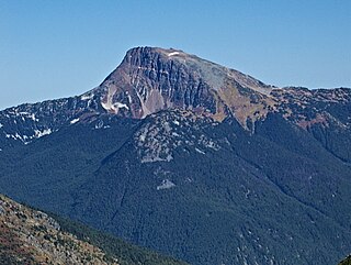
Mount Larrabee is a 7,865-foot (2,397-metre) Skagit Range mountain summit situated 1.4 mile south of the Canada–United States border, in the North Cascades of Washington state. It is located immediately southeast of American Border Peak within the Mount Baker Wilderness, which is part of the Mount Baker-Snoqualmie National Forest, and near North Cascades National Park. It is notable for its reddish coloring caused by oxidation of Iron in the rock. The rock consists of reddish interbedded and interfolded phyllites and greenstone. Originally known as Red Mountain, the name was changed in 1951 to honor Charles F. Larrabee (1895–1950), of the prominent Larrabee family of Bellingham, Washington. The toponym was officially adopted in 1951 by the U.S. Board on Geographic Names.

Mount Rexford is a prominent 2,329-metre (7,641-foot) mountain summit located in the Cascade Mountains of southwestern British Columbia, Canada. It is situated 3.5 km (2 mi) north of the Canada–United States border, 7 km (4 mi) west of Chilliwack Lake, and 5.5 km (3 mi) east of Slesse Mountain, which is its nearest higher neighbor. Precipitation runoff from the peak drains into Nesakwatch and Centre Creeks, both tributaries of the Chilliwack River. Originally known as Ensawkwatch, the mountain was named for an early settler in the area, Rexford, who had a cabin near Slesse Creek and had trap lines in the vicinity. The mountain has two subsidiary peaks known as the Nesakwatch Spires. The mountain's name was officially adopted on June 2, 1950, by the Geographical Names Board of Canada. Mount Rexford was first climbed in July 1951 by Herman Genschorek and Walt Sparling via the West Ridge.

Vicuna Peak, or Vicuña Peak, is a 2,126-metre (6,975-foot) granitic horn located in the North Cascades of southwestern British Columbia, Canada. It is situated 8 km (5 mi) northwest of Coquihalla Summit, 1.47 km (1 mi) northeast of Alpaca Peak, and 1 km (1 mi) southwest of Guanaco Peak, its nearest higher peak, by a mere one metre. Precipitation runoff from the peak drains west into headwaters of the East Anderson River, or east into headwaters of the Coldwater River. The mountain was named for the vicuña, as part of the animal names theme for several other nearby peaks that were submitted by Philip Kubik of the 1974 first ascent party. The mountain's name was officially adopted on February 5, 1976, by the Geographical Names Board of Canada.

Mount McGuire is a 2,008-metre (6,588-foot) mountain summit located in the Cascade Mountains of southwestern British Columbia, Canada. It is situated 4 km (2 mi) north of the Canada–United States border, 19 km (12 mi) southeast of Chilliwack, and 7.4 km (5 mi) northwest of Canadian Border Peak, which is its nearest higher peak. Precipitation runoff from the peak drains into tributaries of the Chilliwack River. The steep western slope of the peak plunges 1800 metres into Tamihi Creek. The mountain was originally known as Tamihi, a Halkomelem name that means "deformed baby finishes." Such infants were sometimes left exposed on the mountain to die. The mountain's name was labelled on 1917 map as McGuire, and officially adopted on October 6, 1936, by the Geographical Names Board of Canada. The peak was first climbed in 1906 by James J. McArthur and survey party via the Southeast Ridge.

Mount MacFarlane is a 2,090-metre (6,860-foot) mountain summit located in the Cascade Mountains of southwestern British Columbia, Canada. It is situated 6 km (4 mi) north of the Canada–United States border, 3.65 km (2 mi) northwest of Slesse Mountain, and 1.4 km (1 mi) northwest of Crossover Peak, which is its nearest higher peak. Precipitation runoff from the peak drains into Slesse Creek and Pierce Creek, both tributaries of the Chilliwack River. The mountain was named to honor Royal Canadian Air Force First Lieutenant Ronald E. MacFarlane, from nearby Chilliwack, who was killed in action on December 16, 1943, at age 21. The name was officially adopted on April 7, 1955, by the Geographical Names Board of Canada.
Mount Grant is a 2,180-metre (7,150-foot) mountain summit located in the Canadian Cascades of southwestern British Columbia, Canada. It is situated 12 km (7 mi) southeast of Hope, and 15 km (9 mi) northwest of Silvertip Mountain. The peak was first climbed June 15, 1951, by Paul Binkert, John Booth, Dick Chambers, Jim Irving, Don Montgomery, and Jim Teevan. The peak was named for Captain John M. Grant of the Royal Engineers by Fred Beckey in his Cascade Alpine Guide. Precipitation runoff from the peak drains into tributaries of the Fraser River.

Crossover Peak is a 2,175-metre (7,136-foot) mountain summit located in the Cascade Mountains of southwestern British Columbia, Canada. It is situated 4.5 km (3 mi) north of the Canada–United States border, 1.6 km (1 mi) southeast of Mount MacFarlane, and 2 km (1 mi) north-northwest of Slesse Mountain, which is its nearest higher peak. Precipitation runoff from the peak drains into Slesse Creek and Nesakwatch Creek, both tributaries of the Chilliwack River. The mountain's name was submitted by Glenn Woodsworth of the Alpine Club of Canada based on the popular cross-over hike from the Pierce Lake trail to the Slesse trail on opposite sides of the peak. The name was officially adopted on May 21, 1981, by the Geographical Names Board of Canada.

Williams Peak is a prominent 2,123-metre (6,965-foot) mountain summit located in the Chilliwack River valley of the Cascade Mountains in southwestern British Columbia, Canada. It is situated 14 km (9 mi) north of the Canada–United States border, 6 km (4 mi) northwest of Chilliwack Lake, and 6.7 km (4 mi) southeast of Foley Peak, which is its nearest higher peak. Williams Peak is the highest point of the South Hope Mountains, which is a subset of the Skagit Range. Precipitation runoff from the peak drains into tributaries of the Chilliwack River. The mountain's name was officially adopted April 7, 1955, by the Geographical Names Board of Canada. Williams Peak was first climbed July 1908 by James J. McArthur and E.T. de Coeli via the southwest ridge.
Mount Outram is a prominent 2,461-metre (8,074-foot) mountain summit located in the Canadian Cascades of southwestern British Columbia, Canada. It is the fourth-highest summit in the Hozameen Range, and highest point of the Manson Ridge subrange. It is situated 23 km (14 mi) southeast of Hope, and 14.5 km (9 mi) north-northeast of Silvertip Mountain, its nearest higher peak. Precipitation runoff from the peak drains into tributaries of the Coquihalla and Skagit Rivers. The mountain was known as Beaver Mountain as early as 1930 before being named for Sir James Outram, 1st Baronet, and being officially adopted October 6, 1936, by the Geographical Names Board of Canada. The first ascent of the mountain was made August 12, 1924, by Fred Perry, Herbert Selwood, Leslie Ford, and T.L. Thacker.

Mount Payne is a 2,468-metre (8,097-foot) mountain summit located in the Canadian Cascades of southwestern British Columbia, Canada. It is situated 27 km (17 mi) southeast of Hope, 14 km (9 mi) northeast of Chilliwack Lake, and 4 km (2 mi) west of Silvertip Mountain, which is its nearest higher peak. Following Silvertip, Mount Payne is the second-highest summit in the Hope Mountains, a subset of the Skagit Range. The peak was first climbed in 1950 by J. Bussell, H. Genschorek, I. Kay, A. Melville, and W. Sparling. The peak was named for Damasus Payne, a Benedictine monk and mountaineer who fell to his death on Edge Peak in 1978. Payne was responsible for naming mountains such as Mount Rohr and Mount Duke. He also carried all the materials for mass and communion up to the summit of Slesse Mountain to perform a ceremony to honor the victims of Trans-Canada Air Lines Flight 810. Mt. Payne's name was officially adopted May 7, 1984, by the Geographical Names Board of Canada. Precipitation runoff from the peak drains into headwaters of the Sumallo River, and into the Klesilkwa River, which is a tributary of the Skagit.

Eaton Peak is a 2,117-metre (6,946-foot) double summit mountain located in the Canadian Cascades of southwestern British Columbia, Canada. It is situated 17 km (11 mi) southeast of Hope, 3 km (2 mi) south of Mt. Grant, and 12.6 km (8 mi) northwest of Silvertip Mountain. The peak was first climbed in 1950 by J. Butcher, F. Rodgers, and E. Jenkins. The peak was named to honor Canadian Army Private Douglas B. Eaton (1911-1944), from nearby Chilliwack, who was killed in action in World War II. The mountain's name was officially adopted April 7, 1955, by the Geographical Names Board of Canada. Nearby Eaton Creek and Eaton Lake were named in memory of his younger brother, William, also killed in action a year earlier. Precipitation runoff from the peak drains into Silverhope Creek, a tributary of the Fraser River.

Mount Webb is a 2,164-meter-elevation (7,100-foot) mountain summit located in the North Cascades in British Columbia, Canada.

Grimface Mountain is a mountain summit in British Columbia, Canada.
Macleod Peak is a 2,176-metre (7,139-foot) mountain summit located in the Canadian Cascades of British Columbia, Canada.

Mount Rideout is a 2,445-metre (8,022-foot) mountain summit located in the Canadian Cascades of British Columbia, Canada.
Mount Forddred is a 2,169-metre (7,116-foot) mountain summit located in the Canadian Cascades of British Columbia, Canada.

Marmot Mountain is a 2,103-metre (6,900-foot) mountain summit located in the Canadian Cascades of British Columbia, Canada.


