
Black Peak is a tall peak in the Cascade Range in the U.S. state of Washington. It lies in the Stephen Mather Wilderness and North Cascades National Park. At 8,975 feet (2,736 m) in elevation it is the 20th-highest peak in Washington. Black Peaks's prominence is 3,450 feet (1,050 m), making it the 35th-most prominent peak in Washington. The nearest higher peak is Goode Mountain, 5.2 miles (8.4 km) to the west-southwest.

Summit Chief Mountain is a 7,467-foot (2,276-meter) mountain summit located on the county line separating King County and Kittitas County in Washington state. It is entirely within the Alpine Lakes Wilderness, on land managed by Mount Baker-Snoqualmie National Forest. Summit Chief Mountain is situated on the crest of the Cascade Range, nine miles northeast of Snoqualmie Pass. Precipitation runoff from the west side of the mountain drains into tributaries of the Snoqualmie River, whereas the east side drains into tributaries of the Yakima River. The nearest higher peak is Chimney Rock, 1.29 miles (2.08 km) to the southwest.

Mount Ballard is an 8,371-foot (2,551-metre) double-summit mountain located in eastern Whatcom County of Washington state. It is part of the Okanogan Range which is a sub-range of the North Cascades Range, and the mountain is situated on land administered by the Okanogan–Wenatchee National Forest. Ballard ranks 84th on Washington's highest 100 peaks. The nearest higher neighbor is Azurite Peak, 2.04 miles (3.28 km) to the south. Precipitation runoff from Mount Ballard drains into Mill Creek and Slate Creek, both tributaries of the Skagit River. Topographic relief is significant as the summit rises approximately 4,000 feet above Mill Creek in one mile (1.6 km).

Apex Mountain is an 8,302-foot (2,530-metre) summit located in Okanogan County in Washington state. It is part of the Okanogan Range which is a sub-range of the North Cascades. The mountain is situated 2.5 miles (4.0 km) south of the Canada–United States border, on the east side of the Cascade crest, in the Pasayten Wilderness, on land managed by the Okanogan–Wenatchee National Forest. The nearest higher peak is Amphitheater Mountain, 2.35 miles (3.78 km) to the west-northwest. The Pacific Northwest Trail traverses the northern slopes of Apex Mountain as it crosses Apex Pass. Precipitation runoff from Apex Mountain drains west into Cathedral Creek, or east into Tungsten Creek, both tributaries of the Chewuch River. Topographic relief is significant as the summit rises 1,200 feet above Tungsten Lake in 0.3 mile (0.5 km).

Windy Peak is an 8,335-foot (2,541-metre) mountain summit located in Okanogan County in Washington state. It is part of the Okanogan Range which is a sub-range of the North Cascades and Cascade Range. The mountain is situated five miles (8.0 km) south of the Canada–United States border, on the east side of the Cascade crest, in the Pasayten Wilderness, on land managed by the Okanogan–Wenatchee National Forest. The nearest higher peak is Haystack Mountain, 9.24 miles (14.87 km) to the northwest in Canada. Precipitation runoff from Windy Peak drains into tributaries of the Methow River and Similkameen River.

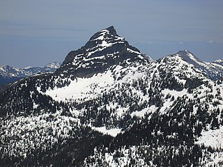
Castle Peak is a prominent 8,343-foot (2,543-metre) mountain summit located in the Hozameen Range of the North Cascades, on the shared border between Okanogan County and Whatcom County of Washington state. The mountain is situated one mile (1.6 km) south of the Canada–United States border, on the Cascade crest, in the Pasayten Wilderness, on land managed by the Okanogan–Wenatchee National Forest. The nearest higher peak is Jack Mountain, 14.8 miles (23.8 km) to the south-southwest. Castle Peak is the second highest summit of the Hozameen Range following Jack Mountain. Castle Peak is the sixth-highest mountain in the Pasayten Wilderness. Precipitation runoff from the mountain drains east into Castle Creek, a tributary of the Similkameen River, or west into tributaries of the Skagit River. Topographic relief is significant as the summit rises nearly 3,000 feet above Crow Creek in 0.75 mile (1.2 km).

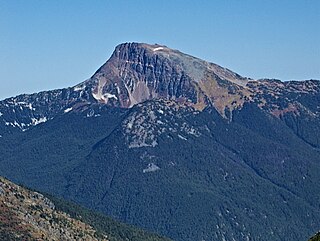
Tiffany Mountain is an 8,245-foot (2,513-metre) mountain summit located in Okanogan County in Washington state. It is the highest point in the Tiffany Range, which is a sub-range of the Okanogan Range. The mountain is situated on the east side of the Cascade crest, on land managed by the Okanogan–Wenatchee National Forest. The nearest higher peak is Windy Peak, 18 miles (29 km) to the north. Precipitation runoff from Tiffany Mountain drains into tributaries of the Columbia River.

Guanaco Peak is a 2,127-metre (6,978-foot) mountain located in the North Cascades of southwestern British Columbia, Canada. It is the highest summit of the Anderson River Group, a subset of the North Cascades. It is situated 8 km (5 mi) northwest of Coquihalla Summit, and 1 km (1 mi) northeast of Vicuna Peak. Precipitation runoff from the peak drains west into headwaters of the East Anderson River, or east into headwaters of the Coldwater River. The mountain was named for the guanaco, as part of the animal names theme for several other nearby peaks that were submitted by Philip Kubik of the 1974 first ascent party. The mountain's name was officially adopted on February 5, 1976, by the Geographical Names Board of Canada.

Steinbok Peak, is a 2,012-metre (6,601-foot) granitic summit located in the North Cascades of southwestern British Columbia, Canada. It is situated 12 km (7 mi) west-northwest of Coquihalla Summit, 1.3 km (1 mi) northwest of Gamuza Peak, and 1 km (1 mi) southeast of Ibex Peak, its nearest higher peak. Precipitation runoff from the peak drains into tributaries of the Anderson River. The mountain was named for the steinbok, as part of the ungulate names theme for several other nearby peaks that were submitted by Philip Kubik of Vancouver. The mountain's name was officially adopted on February 5, 1976, by the Geographical Names Board of Canada. Steinbok was used to represent Kichatna Spire in the 1991 movie K2.

Frosty Mountain is a 2,426-metre (7,959-foot) mountain summit located in the Canadian Cascades of southwestern British Columbia, Canada. It is situated 4 km (2 mi) south of Lightning Lake, 1.3 km (1 mi) north of the Canada–United States border, and 3.6 km (2 mi) north-northeast of Castle Peak, which is its nearest higher peak. Frosty Mountain is the highest peak in E. C. Manning Provincial Park, and is part of the Hozameen Range which is a subrange of the Cascade Range. It has a lower elevation subsidiary peak known as Frosty Mountain East which is labelled as Frosty Mountain on some maps. The Frosty Mountain name was officially adopted on March 31, 1924, by the Geographical Names Board of Canada. The peak was first climbed on September 2, 1904, by Sledge Tatum and George Loudon Jr., two members of a Boundary Survey group led by Edward C. Barnard. Precipitation runoff from the peak drains into headwaters of Frosty Creek, as well as other tributaries of the Similkameen River.
Mount Outram is a prominent 2,461-metre (8,074-foot) mountain summit located in the Canadian Cascades of southwestern British Columbia, Canada. It is the fourth-highest summit in the Hozameen Range, and highest point of the Manson Ridge subrange. It is situated 23 km (14 mi) southeast of Hope, and 14.5 km (9 mi) north-northeast of Silvertip Mountain, its nearest higher peak. Precipitation runoff from the peak drains into tributaries of the Coquihalla and Skagit Rivers. The mountain was known as Beaver Mountain as early as 1930 before being named for Sir James Outram, 1st Baronet, and being officially adopted October 6, 1936, by the Geographical Names Board of Canada. The first ascent of the mountain was made August 12, 1924, by Fred Perry, Herbert Selwood, Leslie Ford, and T.L. Thacker.
Yellow Aster Butte is a 6,241-foot (1,902-metre) Skagit Range summit located three miles south of the Canada–United States border, in Whatcom County of Washington state. It is situated within the Mount Baker Wilderness, on land managed by Mount Baker-Snoqualmie National Forest. The nearest higher neighbor is Winchester Mountain, 1.77 miles (2.85 km) to the east, and Mount Larrabee is set 2.3 miles (3.7 km) to the northeast. The summit offers views of Mount Larrabee, Tomyhoi Peak, American Border Peak, Canadian Border Peak, Mount Shuksan, and Mount Baker. Precipitation runoff on the north side of the mountain drains into Tomyhoi Creek, whereas the west side of the mountain drains into Damfino Creek, and the south slope is drained by Swamp Creek.
Baby Munday Peak is a 2,250-meter-elevation (7,382-foot) mountain summit located in the Cheam Range of British Columbia, Canada.

Knight Peak is a 2,235-metre-elevation (7,333-foot) mountain summit located in the Cheam Range of British Columbia, Canada.

Red Face Mountain is a 7,141-foot-elevation (2,177-meter) summit in Whatcom County of Washington state.

Grimface Mountain is a mountain summit in British Columbia, Canada.
Mount Hatfield is a 2,227-metre (7,306-foot) mountain summit located in the Canadian Cascades of British Columbia, Canada.

Mount Rideout is a 2,445-metre (8,022-foot) mountain summit located in the Canadian Cascades of British Columbia, Canada.
Mount Forddred is a 2,169-metre (7,116-foot) mountain summit located in the Canadian Cascades of British Columbia, Canada.

Marmot Mountain is a 2,103-metre (6,900-foot) mountain summit located in the Canadian Cascades of British Columbia, Canada.


