Mukō

Last updated • 4 min readFrom Wikipedia, The Free Encyclopedia
Mukō
向日市
Muko City Hall.jpg
Mukō City Hall
Flag of Muko, Kyoto.svg
Emblem of Muko, Kyoto.svg
Muko
Location of Mukō in Kyoto Prefecture
Muko in Kyoto Prefecture Ja.svg
Japan location map with side map of the Ryukyu Islands.svg
Red pog.svg
Mukō
Location in Japan
Coordinates: 34°56′55″N135°41′54″E / 34.94861°N 135.69833°E / 34.94861; 135.69833
CountryJapan
Region Kansai
Prefecture Kyoto
Government
  MayorMamoru Yasuda
Area
  Total
7.72 km2 (2.98 sq mi)
Population
 (September 1, 2023)
  Total
56,070
  Density7,300/km2 (19,000/sq mi)
Time zone UTC+09:00 (JST)
City hall address20,Nakano,Terada-cho,Muko-shi,Kyoto-fu 617-0002
Website Official website
Symbols
Flower Sunflower, Azalea [1]
Tree Sakura, Bamboo [1]
Muko, 2020 aerial photography Muko city center area Aerial photograph 2020.jpg
Mukō, 2020 aerial photography
Muko Jinja Muko-jinja, shaden.jpg
Mukō Jinja

Mukō (向日市, Mukō-shi) is a city in Kyoto Prefecture, Japan. As of 1 September 2023, the city has an estimated population of 56,070 in 23748 households and a population density of 2200 persons per km². [2] The total area of the city is 7.72 square kilometres (2.98 sq mi).

Contents

Geography

Mukō is located in southern Kyoto Prefecture. It is located at the southwestern edge of the Kyoto Basin, with views of the Nishiyama mountain range including Mt. Koshio to the west, and the Katsura River flowing to the east of the city. As a result, the terrain is generally flat with highlands to the northwest and lowlands to the southwest. Muko adjoins northern Nagaoka, is surrounded by Kyoto on other three sides. There are bamboo groves found on the hillside on the west of the city. Residential area for Kyoto and Osaka is expanded to the hill, encroaches on bamboo groves. The Itsuka Kofun  [ ja ], the large keyhole-shaped kofun dated to 4th century, is located in the center of the hill chain.

Neighboring municipalities

Flag of Kyoto Prefecture.svg Kyoto Prefecture

Climate

Mukō has a humid subtropical climate (Köppen Cfa) characterized by warm summers and cool winters with light to no snowfall. The average annual temperature in Mukō is 14.5 °C. The average annual rainfall is 1667 mm with September as the wettest month. The temperatures are highest on average in August, at around 26.5 °C, and lowest in January, at around 3.1 °C. [3]

Demographics

Per Japanese census data, [4] the population of Mukō saw rapid growth in the late 20th century as the city developed as a residential community, and it has grown at a slower pace since then. According to the provisional results of the 2015 national census of Japan, the population of Muko is 56,859; of which male and female are 27,119 and 29,740 respectively. [4]

Historical population
YearPop.±%
1886 3,528    
1920 4,712+33.6%
1925 5,188+10.1%
1930 5,959+14.9%
1940 8,072+35.5%
1950 9,243+14.5%
1960 12,734+37.8%
1970 36,988+190.5%
1980 50,604+36.8%
1990 52,928+4.6%
2000 53,425+0.9%
2010 54,328+1.7%
2020 56,859+4.7%
[4]

History

The area of Mukō was part of ancient Yamashiro Province. At the end of the 8th century, Emperor Kanmu moved his capital from Heijō-kyō to Nagaoka-kyō. The new capital encompassed a large part of modern Muko, where modern research has revealed the palace to have been located. In the south, it also included parts of Nagaokakyō. In 794, because of the location's moist temperature and reputation as a breeding ground for disease, Kammu relocated his capital from Nagaoka to Heian-kyō, now known as Kyoto. [5] Mukō developed as a market town in 1592, during Azuchi–Momoyama period. The town's main road, called Saigoku Kaido, flourished because it connected Tō-ji in Kyoto and Nishinomiya Shrine in Settsu Province. Saigoku Kaido, which still presents a traditional and historical setting, changed name National Route 171 as important road. [6]

Modern Mukō

The town of Mukō was established on April 1, 1889 with the creation of the modern municipalities system. Mukōmachi Station opened on July 26, 1876. Higashi-Mukō Station and Nishi-Mukō Station opened on December 1, 1928. Mukō was elevated to city status on October 1, 1972. [6]

Government

Mukō has a mayor-council form of government with a directly elected mayor and a unicameral city council of 18 members. Mukō, collectively with Nagaokakyō, contributes two members to the Kyoto Prefectural Assembly. In terms of national politics, the city is part of the Kyoto 3rd district of the lower house of the Diet of Japan.

Economy

Mukō has a mixed economy based on commerce and light manufacturing.

There is an Aeon Department Store, a Japanese restaurant and a casual dining area. A specialty tea stand on the first floor sells a variety of tea from around Japan.

Education

Mukō has six public elementary schools and three public junior high schools operated by city government and one public high school operated by the Kyoto Prefectural Board of Education. There is also one private elementary school and one private high school.

Transportation

Railways

JR logo (west).svg JR West - Tōkaidō Main Line (JR Kyoto Line)

Hankyu Railway Logo.svg Hankyu - Kyoto Main Line

Highways

Sister cities

Related Research Articles

<span class="mw-page-title-main">Kawaguchi, Saitama</span> Core city in Kantō, Japan

Kawaguchi is a city located in Saitama Prefecture, Japan. As of 1 January 2021, the city had an estimated population of 607,373 in 293,582 households and a population density of 9800 persons per km². The total area of the city is 61.95 square kilometres (23.92 sq mi). It is the Greater Tokyo Area's 8th most populated city, and second largest in Saitama Prefecture, after eponymous Saitama.

<span class="mw-page-title-main">Ōmihachiman</span> City in Kansai, Japan

Ōmihachiman is a city located in Shiga Prefecture, Japan. As of 31 August 2021, the city had an estimated population of 82,233 in 34747 households and a population density of 570 persons per km2. The total area of the city is 76.97 square kilometres (29.72 sq mi).

<span class="mw-page-title-main">Kameoka, Kyoto</span> City in Kansai, Japan

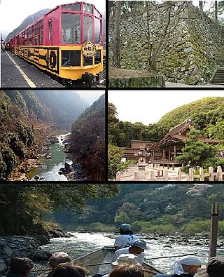
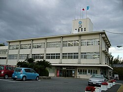
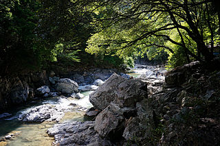
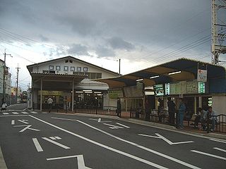
Kameoka is a city in Kyoto Prefecture, Japan. As of 1 January 2022, the city had an estimated population of 87,518 in 29,676 households and a population density of 390 persons per km2. The total area of the city is 224.80 square kilometres (86.80 sq mi).

<span class="mw-page-title-main">Nagaokakyō, Kyoto</span> City in Kansai, Japan

Nagaokakyō is a city located in Kyoto Prefecture, Japan. As of 1 September 2023, the city has an estimated population of 82,279 in 37718 households and a population density of 4700 persons per km2. The total area of the city is 19.17 square kilometres (7.40 sq mi).

<span class="mw-page-title-main">Suita</span> Core city in Kansai, Japan

Suita is a city located in Osaka Prefecture, Japan. As of 31 March 2023, the city had an estimated population of 381,238 in 182636 households and a population density of 11,000 persons per km2. The total area of the city is 36.09 square kilometres (13.93 sq mi). It is a suburban city of Osaka City and a part of the Kyoto-Osaka-Kobe metropolitan area.

<span class="mw-page-title-main">Takatsuki</span> Core city in Kansai, Japan

Takatsuki is a city in Osaka Prefecture, Japan. As of 31 March 2023, the city had an estimated population of 348,020 in 164,494 households and a population density of 3.300 persons per km2. The total area of the city is 105.29 square kilometres (40.65 sq mi).

<span class="mw-page-title-main">Ibaraki, Osaka</span> Special city in Kansai, Japan

Ibaraki is a city in Osaka Prefecture, Japan. As of 31 March 2023, the city had an estimated population of 285,224 in 132,300 households and a population density of 3,700 persons per km2. The total area of the city is 76.49 square kilometres (29.53 sq mi). It is a suburban city of Osaka City and a part of the Kyoto-Osaka-Kobe metropolitan area.

<span class="mw-page-title-main">Habikino</span> City in Kansai, Japan

Habikino is a city located in Osaka Prefecture, Japan. As of 31 January 2022, the city had an estimated population of 109,479 in 50918 households and a population density of 4100 persons per km2. The total area of the city is 26.45 square kilometres (10.21 sq mi). The city is known for its grapes, and also for its large number of ancient kofun burial mounds. The city is also sometimes referred to by its former name Minami-Osaka (南大阪).

<span class="mw-page-title-main">Nishinomiya</span> Core city in Kansai, Japan

Nishinomiya is a city located in Hyōgo Prefecture, Japan. As of 1 November 2022, the city had an estimated population of 484,368 in 218,948 households and a population density of 4,800 persons per km². The total area of the city is 99.98 square kilometres (38.60 sq mi). Nishinomiya is an important commercial and shipping city in the Kansai region with the third largest population in Hyōgo Prefecture. Nishinomiya is best known as the home of Koshien Stadium, where the Hanshin Tigers baseball team plays home games and where Japan's annual high school baseball championship is held.

<span class="mw-page-title-main">Tatsuno, Hyōgo</span> City in Kansai, Japan

Tatsuno is a city in Hyōgo Prefecture, Japan. As of 31 May 2022, the city had an estimated population of 74,414 in 31119 households and a population density of 6200 persons per km2. The total area of the city is 49.42 square kilometres (19.08 sq mi).

<span class="mw-page-title-main">Takarazuka, Hyōgo</span> City in Kansai, Japan

Takarazuka is a city located in Hyōgo Prefecture, Japan. As of 1 February 2024, the city had an estimated population of 221,846 in 96,729 households and a population density of 2,200 persons per km². The total area of the city is 101.80 square kilometres (39.31 sq mi). Known as the "inner parlor" of Kansai, Takarazuka is famous for the Takarazuka Revue, hot springs, and the Takarazuka Tourism Fireworks Display held since 1913. It is also famous as a choice residential area along with Ashiya and Nishinomiya.

<span class="mw-page-title-main">Higashimurayama, Tokyo</span> City in Kantō, Japan

Higashimurayama is a city located in the western portion of the Tokyo Metropolis, Japan. As of 1 March 2021, the city had an estimated population of 148,275, and a population density of 8700 persons per km2. The total area of the city is 17.14 square kilometres (6.62 sq mi).

<span class="mw-page-title-main">Nagaoka-kyō</span> Historical capital of Japan

Nagaoka-kyō (長岡京) was the capital of Japan from 784 to 794. Its location was in Otokuni District, Yamashiro Province, corresponding to a 4.3 x 5.3 kilometer area spanning the borders of modern cities of Mukō and Nagaokakyō, Kyoto, the town of Ōyamazaki, and the Nishikyō-ku ward of the city of Kyoto. The ruins of the palace have been found in the Kaidecho neighbourhood of the city of Mukō and have been designated as a National Historic Site since 1964, with the area under protection expanded in 2016.

<span class="mw-page-title-main">Mukōmachi Station</span> Railway station in Mukō, Kyoto Prefecture, Japan

Mukōmachi Station is a passenger railway station located in the city of Mukō, Kyoto Prefecture, Japan. It is operated by the West Japan Railway Company. Mukōmachi Station is one of three railway stations in the city of Mukō; the others are Nishi-Mukō and Higashi-Mukō stations on the Hankyu Kyoto Line.

<span class="mw-page-title-main">Nagaokakyō Station</span> Railway station in Nagaokakyō, Kyoto Prefecture, Japan

Nagaokakyō Station is a passenger railway station located in the city of Nagaokakyō, Kyoto Prefecture, Japan, operated by the West Japan Railway Company. Nagaokakyō Station is one of the two railway stations in the city of Nagaokakyō. The other is Nagaoka-Tenjin Station on the Hankyu Kyoto Line.

<span class="mw-page-title-main">Nagaoka-Tenjin Station</span> Railway station in Nagaokakyō, Kyoto Prefecture, Japan

Nagaoka-Tenjin Station is a passenger railway station located in the city of Nagaokakyō, Kyoto Prefecture, Japan. It is operated by the private transportation company, Hankyu Railway.

<span class="mw-page-title-main">Nishi-Mukō Station</span> Railway station in Mukō, Kyoto Prefecture, Japan

Nishi-Mukō Station is a passenger railway station located in the city of Mukō, Kyoto Prefecture, Japan. It is operated by the private railway operator Hankyu Railway.

<span class="mw-page-title-main">Higashi-Mukō Station</span> Railway station in Mukō, Kyoto Prefecture, Japan

Higashi-Mukō Station is a passenger railway station located in the city of Mukō, Kyoto Prefecture, Japan. It is operated by the private transportation company, Hankyu Railway.

<span class="mw-page-title-main">Mukonosō Station</span> Railway station in Amagasaki, Hyōgo Prefecture, Japan

Mukonosō Station is a passenger railway station located in the city of Amagasaki, Hyōgo Prefecture, Japan. It is operated by the private transportation company Hankyu Railway.

<span class="mw-page-title-main">Nishiyama Tennozan Station</span> Railway station in Nagaokakyō, Kyoto Prefecture, Japan

Nishiyama-Tennōzan Station is a passenger railway station located in the city of Nagaokakyō, Kyoto, Japan. It is operated by the private railway operator Hankyu Railway.

References

  1. 1 2 向日市民の花・木 (in Japanese). Muko city. Retrieved 11 February 2018.
  2. "Mukō City official statistics" (in Japanese). Japan.
  3. Mukō climate: Average Temperature, weather by month
  4. 1 2 3 "国勢調査 (Population Census)" (in Japanese). Kyoto Prefectural Office. Retrieved 3 May 2022.
  5. 長岡京とは (in Japanese). Muko city. Retrieved 11 February 2018.
  6. 1 2 向日市が歩んだ歴史 (in Japanese). Muko city. Retrieved 11 February 2018.
  7. "Saratoga and Muko, Japan, celebrate 30 years as sister cities". mercurynews. 19 March 2014. Retrieved 27 August 2014.