Multicoloured tanager

Last updated

Multicoloured tanager
Multicolored tanager chicoral.jpg
Scientific classification OOjs UI icon edit-ltr.svg
Domain: Eukaryota
Kingdom: Animalia
Phylum: Chordata
Class: Aves
Order: Passeriformes
Family: Thraupidae
Genus: Chlorochrysa
Species:
C. nitidissima
Binomial name
Chlorochrysa nitidissima
Chlorochrysa nitidissima map.svg

The multicoloured tanager (Chlorochrysa nitidissima) is a species of bird in the family Thraupidae. It is endemic to the mountains of Colombia, and as of 2010 has been categorized as vulnerable (VU) by the IUCN. [2]

Contents

Description

The multicolored tanager is a small-sized passerine bird approximately 12 cm (5 in.) long. [3] Males have a yellow crown, face, mantle, and throat; chestnut and black ear coverts; bright green nape and wings; blue rump, breast, and belly; and a black patch in the center of the underparts. [4] Females are duller and lack the yellow mantle and black patch on the underparts. [5] Immature birds of both sexes resemble females, but are duller. [6]

Etymology

The genus name Chlorochrysa refers to the bright green and yellow regions of the plumage. The species name nitidissima means "very bright", referring to the beauty of its plumage. [7]

Distribution and habitat

The multicolored tanager is endemic to the interior of wet montane forests of the Occidental and Central Cordillera of Colombia. [1] It is found mainly from 1300 to 2200 meters above sea level; however, some records indicate it can be found as low as 900 meters, especially in the Department of Cauca. [8] It has been recorded in the Departments of Cauca, Valle del Cauca, Choco, Quindío, Risaralda, Caldas, and Antioquia. It seems to prefer mature forests, although it has also been recorded in mature secondary forests and forest edges. [6] Most of the recent records of the species come from the Valle del Cauca Department, where it resides year-round and remains fairly common even in small forest fragments. [1] [9]

Food and feeding

This species is most often found as part of mixed-species flocks in the upper canopy of the forest. [9] It usually searches for insects on the underside of leaves of outer limbs while clinging to leaves with its feet. [8] It has also been reported eating ripe fruit, mainly from the genera Cordia , Miconia , Palicourea , and Ficus . [9]

Breeding

Information on breeding behavior and seasonality of the species mostly consists of individual and isolated records. Hilty and Brown [8] reported a stub-tailed juvenile with two adults on 1 November, and a grown juvenile on 8 January. Both records came from the West Andes above Cali, Valle del Cauca (Occidental Cordillera). In August 1990, two adults were recorded feeding chicks in the same area, and in January 2000, a juvenile and two adults were observed eating fruit near the Bitaco River Forest Reserve in Chicoral, Valle del Cauca. One juvenile and one adult male were recorded on 11 February 2001 at Kilometer 18 on the Cali-Buenaventura highway. Records from the Central Cordillera include sightings of two juveniles and adults in March 2000 in La Magdalena, above Buga. During 1996, juveniles of the species were observed at the Santuario de Fauna y Flora Otún-Quimbaya, and Parque Regional Ucumarí, in the department of Risaralda. Three specimens in reproductive condition and one immature bird were collected in May and June in the Central Cordillera (specimens located at USNM). [9] Collectively, these data suggest that adults breed from November to August, a common pattern among tropical resident birds. [10]

Conservation status

The IUCN has listed this species as vulnerable, mainly because of its small range, and also because it is only known from a small number of locations. [1] The multicolored tanager used to be fairly common, but population declines have been recorded throughout its range owing to ongoing habitat destruction, and nowadays it is only encountered very infrequently, primarily in remnant forest fragments. [6] Habitat loss and fragmentation are major threats to the species: approximately 81% of its habitat has been lost to date. [9] Renjifo [11] [12] suggested that this species is very sensitive to habitat fragmentation as it is found in 16% of point counts from interior, continuous forest, but in only 3% of point counts in forest fragments. The expanding network of roads across the species' range has led to increases in logging, mining, agriculture, and human settlement. [6] Although the species occurs in protected areas with large tracts of suitable habitat like Farallones de Cali, Munchique, and Los Nevados National Parks, most recent records come from unprotected and private forests in the Valle del Cauca Department. [9] Proposed conservation actions include increasing the number and size of protected areas within the species' range, as well as enforcing conservation measures in previously protected areas, and providing non-damaging alternatives to settlers. Scientific research studies are necessary in order to accurately estimate the size of the different subpopulations and to gain insight about the species' ecological requirements. [1]

Most recent records for the multicolored tanager come from the Valle del Cauca department, in the Western Andes right outside Cali. Since the construction of the Cali-Buenaventura road during the first decade of the twentieth century, this area has been heavily transformed, mainly for agriculture and cattle ranching, and the remaining forest patches range from 10 to 400 ha. [9] Two Important Bird Areas (Chicoral and San Antonio) have been declared in the area within the last two decades, which has led to increasing awareness in the local community to bird conservation. [13] These areas are connected to Los Farallones National Park (also an Important Bird Area), which has a total area of around 150,000 ha. Seven Civil Society Reserves and one Regional Reserve are also part of the habitat protected for this and other threatened species in the locality. [14] Bosque de Yotoco Reserve is another Important Bird Area in the Valle del Cauca department where this species occurs. [13] In addition to protected areas, several NGOs work in various aspects of conservation in the zone, especially environmental education with the local communities. [4]

Related Research Articles

<span class="mw-page-title-main">Chocó Department</span> Department of Colombia

Chocó Department is a department of the Pacific region of Colombia known for hosting the largest Afro-Colombian population in the nation, and a large population of Amerindian and mixed African-Amerindian Colombians. It is in the west of the country, and is the only Colombian department to have coastlines on both the Pacific Ocean and the Atlantic Ocean. It contains all of Colombia's border with Panama. Its capital is Quibdó.

<span class="mw-page-title-main">Valle del Cauca Department</span> Department of western Colombia

Valle del Cauca, or Cauca Valley, is a department in western Colombia abutting the Pacific Ocean. Its capital is Santiago de Cali. Other cities such as Buenaventura, Buga, Cartago, Palmira and Tuluá have great economical, political, social and cultural influence on the department's life. Valle del Cauca has the largest number of independent towns with over 100,000 inhabitants in the country, counting six within its borders. Buenaventura has the largest and busiest seaport in Colombia, moving about 8,500,000 tons of merchandise annually.

<span class="mw-page-title-main">Cauca guan</span> Species of bird

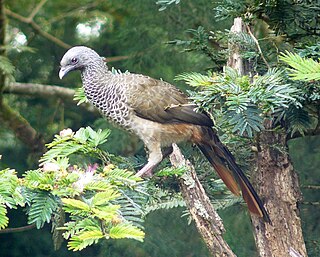
The Cauca guan is a bird in the chachalaca, guan and curassow family, Cracidae. It is a large guan, and like most guans leads a mostly arboreal life in humid forests, where it forages for fruit and leaves. The Cauca guan is endemic to Colombia's Cauca River valley.

<span class="mw-page-title-main">Cordillera Occidental (Colombia)</span> Mountain range in Colombia

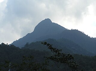
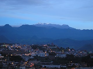
The Cordillera Occidental is the lowest in elevation of the three branches of the Colombian Andes. The average altitude is 2,000 m (6,600 ft) and the highest peak is Cerro Tatamá at 4,100 m (13,500 ft). The range extends from south to north dividing from the Colombian Massif in Nariño Department, passes north through Cauca, Valle del Cauca, Risaralda, Chocó, and Caldas Departments to the Paramillo Massif in Antioquia and Córdoba Departments. The cordillera is paralleled on the east by the Cauca river. From this massif the range divides further to form the Serranías de Ayapel, San Jerónimo and Abibe. Only to recede into the Caribbean plain and the Sinú River valley.

Gastrotheca antomia is a species of frog in the family Hemiphractidae. It is endemic to Colombia and found on the western versant of the Cordillera Occidental in Antioquia, Risaralda, Chocó, and Valle del Cauca Departments, at elevations of 1,140–2,500 m (3,740–8,200 ft) asl.

<span class="mw-page-title-main">Flame-winged parakeet</span> Species of bird

The flame-winged parakeet, also known as the brown-breasted parakeet, is a species of parrot in the family Psittacidae. It is endemic to forest edge and shrub at altitudes of 1,700–3,400 m (5,600–11,200 ft) above sea level on the east Andean slope in Colombia. It is threatened by habitat loss.

<span class="mw-page-title-main">Gold-ringed tanager</span> Species of bird

The gold-ringed tanager is a species of bird in the family Thraupidae, endemic to Colombia. It is a plump, relatively short-tailed tanager with a distinctive gold ring around its face. It inhabits a narrow band of high-altitude cloud forest on the slopes of the western cordillera of the Andes, where it survives on a diet of fruit and insects. The bird is found in small numbers within a limited geographical area, and much of its breeding biology has yet to be described. It is considered a vulnerable species, threatened by habitat loss.

<span class="mw-page-title-main">Scarlet-and-white tanager</span> Species of bird from South America

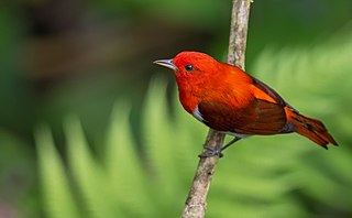
The scarlet-and-white tanager is a species of bird in the family Thraupidae. It is found in Colombia and northern Ecuador. Its natural habitats are subtropical or tropical moist lowland forests and heavily degraded former forest. The male is highly distinctive and has bright scarlet upperparts, darker red wings and undertail coverts, and white underparts with a scarlet median stripe running down the throat and belly. Females are patterned like the males, but are olive-brown instead of scarlet.

<span class="mw-page-title-main">Chestnut-bellied flowerpiercer</span> Species of bird

The chestnut-bellied flowerpiercer is a species of bird in the family Thraupidae. It is endemic to Colombia.

Trigonobalanus excelsa, commonly called the Colombian black oak, is a species of plant in the family Fagaceae. It is a tree endemic to Colombia.

<span class="mw-page-title-main">Colombian chachalaca</span> Species of bird

The Colombian chachalaca is a species of bird in the family Cracidae. It is endemic to the forests and woodlands in the inter-Andean valleys in Colombia. Colombian Chachalacas are frugivorous and lead an arboreal lifestyle. The large seeds they disperse through defecation support the maintenance of diverse tropical forests.

<span class="mw-page-title-main">Farallones de Cali</span> Mountains in Colombia

Farallones de Cali is a cluster of mountains in the West Andes of Colombia. It is located west of the city of Cali and gives rise to many of the rivers that provide water and electricity to Cali. The PNN Farallones de Cali encompasses 150,000 ha (580 sq mi) in the mountains as well as much of the Pacific slope and is an area of very high biodiversity. The average temperature ranges from 25 °C (77 °F) in the tropical foothills to 5 °C (41 °F) in the páramo. In this territory are located the district of Pichinde, Andes and Leonera, and two villages Penas Blancas and Lomas de la Cajita.

<span class="mw-page-title-main">Dapa, Valle del Cauca</span> Town in Valle del Cauca, Colombia

Dapa is a small village and area of weekend homes in the Valle del Cauca Department of west central Colombia. It is located in the mountains about 15 kilometers northwest of the city of Cali. It is a township within the Municipality of Yumbo.

<span class="mw-page-title-main">Chicoral, Valle del Cauca</span> Region in Valle del Cauca Department, Colombia

The area of Chicoral is located in the southernmost part of the township of Bitaco and within the municipality of La Cumbre in the Valle del Cauca Department of Colombia. It is home to the Hindú Tea Plantation, a major part of the Bitaco River Forest Reserve, and many small estates and farms. This region is only accessible by unpaved roads by way of La Cumbre from the north, the Cali-Buenaventura Road from the west and Dapa from the east through a forested pass at 2,100 m (6,900 ft).

El Queremal is a town in the Dagua municipality, Valle del Cauca Department, Colombia. It is located about 47 km (29 mi) west of Cali and is at an elevation of 1,450 m (4,760 ft). The town is situated on the upper part of the Old Cali-Buenaventura Road and is about 99 km (62 mi) from Buenaventura, the main Colombian port on the Pacific. The town is accessible from Cali from several roads leading away from the main Cali-Buenaventura Road near the area of Kilometer 18, Valle del Cauca.

<span class="mw-page-title-main">Northwestern Andean montane forests</span>

The Northwestern Andean montane forests (NT0145) is an ecoregion on the Andes mountains in the west of Colombia and Ecuador. Both flora and fauna are highly diverse due to effect of ice ages when the warmer climate zones were separated and the cooler ones combined, and interglacial periods when the reverse occurred. Because the environment is hospitable to humans, the habitat has been drastically modified by farming and grazing since the Pre-Columbian era.

<span class="mw-page-title-main">Cauca Valley montane forests</span> Ecoregion in western Colombia

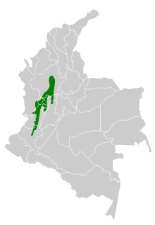
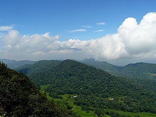
The Cauca Valley montane forests (NT0109) is an ecoregion in western Colombia. It covers the sides of the Cauca Valley, which runs from south to north between the Central and Western Ranges (cordilleras) of the Colombian Andes. The ecoregion is home to very diverse fauna and flora, due in part to its varied elevations and climates, in part to its position near the isthmus of Panama, the route along which North American species invaded South America and then diversified as they moved to the upper parts of the Andes. Little of the original habitat remains at lower levels, but higher up there are sizeable blocks of forest, some of which are protected.

<i>Lepidoblepharis duolepis</i> Species of lizard

Lepidoblepharis duolepis is a species of gecko, a lizard in the family Sphaerodactylidae. The species is endemic to Colombia.

Tatamá National Natural Park is a national park in the Cordillera Occidental, Colombia. Established in 1987, the park encompasses 51,900 ha of primary west-Andean tropical and subtropical rainforest, temperate cloud forest, and páramo habitat in an area that spans the departments of Risaralda, Chocó and Valle del Cauca, within the Chocó bioregion.

Pristimantis jubatus is a species of frog in the family Strabomantidae. It is endemic to Cordillera Occidental and is known from the vicinity of its type locality in the Munchique National Park and from Farallones de Cali. The specific name jubatus is Latin for "crested" and refers to the cranial crests of this frog.

References

  1. 1 2 3 4 5 BirdLife International (2019). "Chlorochrysa nitidissima". IUCN Red List of Threatened Species . 2019: e.T22722799A154089187. doi: 10.2305/IUCN.UK.2019-3.RLTS.T22722799A154089187.en . Retrieved 13 November 2021.
  2. BirdLife International (2000). Threatened birds of the world . Barcelona, España, Cambridge, UK: Lynx Editions and BirdLife International.
  3. Isler, M. L.; Isler, P. R.; color plates by Morton L. (1999). The tanagers : natural history, distribution, and identification . Washington, D.C.: Smithsonian Institution Press. ISBN   0-87474-553-5.{{cite book}}: CS1 maint: multiple names: authors list (link)
  4. 1 2 Corporación Autónoma Regional del Valle del Cauca - CVC (2010). Bolivar, W.; Eusse, D.; Castro Herrera, F.; Fierro, K.; Cifuentes Sarmiento, Y.; Falk Fernández, P.; Tello, S.; Neira, L. A. (eds.). Aves y herpetos de la Reserva Forestal Protectora Regional de Bitaco. Santiago de Cali: CVC. p. 170. ISBN   978-958-8332-40-6.
  5. "BirdLife International (2015) Species factsheet: Chlorochrysa nitidissima". Archived from the original on 2016-03-04. Retrieved 2015-03-23.
  6. 1 2 3 4 del Hoyo, J.; Elliott, A.; Christie, D. A., eds. (2011). Handbook of the Birds of the World. Vol 16. Tanagers to New World Blackbirds. Barcelona: Lynx Edicions.
  7. Jobling, J. A. (2010). The Helm dictionary of scientific bird names : from aalge to zusii. London: Christopher Helm. ISBN   978-1-4081-2501-4.
  8. 1 2 3 Hilty, S. L.; Brown, W. L. (1986). Birds of Colombia. Princeton: Princeton University Press.
  9. 1 2 3 4 5 6 7 L. M. Renjifo; et al., eds. (2002). Libro rojo de aves en Colombia (1a. ed.). Bogotá, D.C.: Instituto de Investigación de Recursos Biológicos Alexander von Humboldt. ISBN   958-8151-08-2.
  10. Johnson, E. I.; Stouffer, P. C.; Bierregaard Jr, O. (2012). "The phenology of molting, breeding and their overlap in central Amazonian birds". Journal of Avian Biology. 43 (2): 141–154. doi:10.1111/j.1600-048x.2011.05574.x.
  11. Renjifo, L. M. (1999). "Composition changes in a subandean avifauna after long-term forest fragmentation". Conservation Biology. 13 (5): 1124–1139. doi:10.1046/j.1523-1739.1999.98311.x.
  12. Renjifo, L. M. (2001). "Effect of natural and anthropogenic landscape matrices on the abundance of subandean bird species". Ecological Applications. 11: 14–31. doi:10.1890/1051-0761(2001)011[0014:eonaal]2.0.co;2.
  13. 1 2 Devenish, C.; Diaz-Fernandez, D. F.; Clay, R. P.; Yepez-Zabala, I., eds. (2009). Important Bird Areas Americas - Priority sites for biodiversity conservation. Quito, Ecuador: BirdLife International (BirdLife Conservation Series No. 16).
  14. Fierro-Calderón, K.; Montealegre, C.; Fierro-Calderón, E.; Eusse, D. (2009). Five threatened species in the western Andes of Colombia. Future Conservationist Awards. Calidris, Cali.