
Santa Rosa County is a county located in the northwestern portion of the U.S. state of Florida. As of 2020, the population is 188,000. The county seat is Milton, which lies in the geographic center of the county. Other major communities within Santa Rosa County are Navarre, Pace, and Gulf Breeze. Navarre is the most populated community with a population of approximately 45,000 residents. Santa Rosa County is included in the Pensacola Metropolitan Statistical Area, which also includes Escambia County.

Century is a town in Escambia County, Florida, United States. Per the 2020 census, the population was 1,713. It is part of the Pensacola–Ferry Pass–Brent Metropolitan Statistical Area.

Cheval is a census-designated place in Hillsborough County, Florida, United States. The population was 10,702 at the 2010 census, up from 7,602 at the 2000 census.

Dover is an unincorporated census-designated place in Hillsborough County, Florida, United States. The population was 3,266 at the 2020 census, down from 3,702 at the 2010 census.

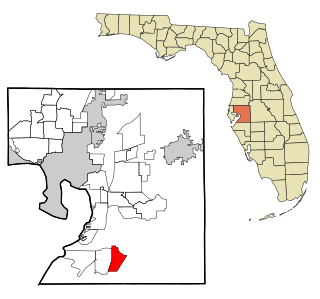
East Lake-Orient Park is an unincorporated census-designated place in Hillsborough County, Florida, United States. The population was 22,753 at the 2010 census, up from 5,703 at the 2000 census following an expansion of its borders. The area is the home of the Florida State Fairgrounds, which hosts the Florida State Fair in mid-February of each year. It was previously home to East Lake Square Mall. The ZIP code for East Lake-Orient Park is 33610 and 33619.

Mango is a census-designated place (CDP) in Hillsborough County, Florida, United States. The population was 11,313 at the 2010 census, up from 8,842 at the 2000 census.

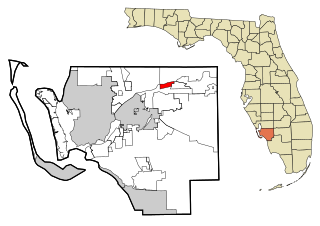
Thonotosassa is a census-designated place (CDP) in Hillsborough County, Florida, United States. The population was 15,238 at the 2020 census, up from 13,014 at the 2010 census.

University is an unincorporated census-designated place in Hillsborough County, Florida, United States. The population was 41,163 at the 2010 census, up from 30,736 at the 2000 census. The University of South Florida is located just southeast of the community, within the Tampa city limits. The community is also known as "University West", mainly due to its location in relation to the university. The community is often notoriously referred to by locals as "Suitcase City" due to the high rate of transients.
Wimauma is an unincorporated census-designated place in Hillsborough County, Florida, United States. The population was 6,373 at the 2010 census, up from 4,246 at the 2000 census.

Okahumpka is an unincorporated community and census-designated place (CDP) in Lake County, Florida, United States. The population was 267 at the 2010 census. It is part of the Orlando–Kissimmee Metropolitan Statistical Area.

Estero is a village in Lee County, Florida, United States. As of the 2020 census, the population was 36,939. During the 2010 census, Estero was an unincorporated community, or census-designated place, the population at that time was 22,612. Estero incorporated as a village in 2014. In 2019, the village's estimated population was 33,871. Estero is part of the Cape Coral-Fort Myers, Florida Metropolitan Statistical Area.
Fort Myers Shores is an unincorporated community and census-designated place (CDP) in Lee County, Florida, United States. The population was 5,774 at the 2020 census. It is part of the Cape Coral-Fort Myers, Florida Metropolitan Statistical Area.

Iona is an unincorporated community and census-designated place (CDP) in Lee County, Florida, United States. The population was 16,908 at the 2020 census, up from 15,404 at the 2010 census. It is part of the Cape Coral-Fort Myers, Florida Metropolitan Statistical Area.

Tice is an unincorporated community and census-designated place (CDP) in Lee County, Florida, United States. As of the 2020 census, the CDP population was 4,853. It is part of the Cape Coral-Fort Myers, Florida Metropolitan Statistical Area.

Villas, Florida is an unincorporated community and census-designated place (CDP) in Lee County, Florida, United States. It is part of the Cape Coral-Fort Myers, Florida Metropolitan Statistical Area.

Goulds is an unincorporated community and census-designated place (CDP) in Miami-Dade County, Florida, United States. The area was originally populated as the result of a stop on the Florida East Coast Railroad. The railroad depot was located near the current Southwest 224th Street. The community was named after its operator, Lyman Gould, who cut trees for railroad ties. As of the 2020 census, the population stood at 11,446, up from 10,103 in 2010.

Leisure City is an unincorporated community and census-designated place (CDP) in Miami-Dade County, Florida, United States, that includes the smaller, older community of Modello in its northwestern section. The population was 26,324 at the 2020 census, up from 22,655 in 2010. It is most notable for the Coral Castle Museum, located in the Modello area.
Munsons Corners is a hamlet and census-designated place (CDP) in Cortland County, New York, United States. The population was 2,728 at the 2010 census.

Chardon is a city in and the county seat of Geauga County, Ohio, United States. The population was 5,242 at the 2020 census. It is the only incorporated city in Geauga County, and includes land that was once part of Chardon, Hambden and Munson townships. It is located about 10 miles south of Lake Erie and within the "snow belt" of the Great Lakes and is part of the Cleveland metropolitan area.

Beaver is an unincorporated community in Tillamook County, Oregon, United States, along U.S. Route 101 and the Nestucca River, about 12 miles (19 km) south of Tillamook. For statistical purposes, the United States Census Bureau has defined Beaver as a census-designated place (CDP). The census definition of the area may not precisely correspond to local understanding of the area with the same name. The population of the CDP was 122 at the 2010 census.


