
Hamilton County is a county located in the north central portion of the U.S. state of Florida. As of the 2020 census, the population was 14,004, down from 14,799 at the 2010 census. Its county seat is Jasper.
Wimauma is an unincorporated census-designated place in Hillsborough County, Florida, United States. The population was 6,373 at the 2010 census, up from 4,246 at the 2000 census.

Gateway is a census-designated place (CDP) in Lee County, Florida, United States. The population was 8,401 at the 2010 United States Census. It is part of the Cape Coral-Fort Myers, Florida Metropolitan Statistical Area. The community is located north of Southwest Florida International Airport.

Pine Manor is a census-designated place (CDP) located off U.S. Route 41 and Summerlin Road in Lee County, Florida, United States. The population was 4,122 at the 2020 census, up from 3,428 at the 2010 census. It is part of the Cape Coral-Fort Myers, Florida Metropolitan Statistical Area.

Suncoast Estates is a census-designated place (CDP) in Lee County, Florida, United States. The population was 4,384 at the 2010 census, down from 4,867 at the 2000 census. It is part of the Cape Coral-Fort Myers, Florida Metropolitan Statistical Area.

Naranja is an unincorporated community and census-designated place (CDP) in Miami-Dade County, Florida, United States. Many orange groves were once located in this area, so the community name came from the Spanish word for orange, naranja, though the pronunciation among the local residents is "Na-Ran-Jah". Naranja was also a stop for the Florida East Coast Railroad that once ran through this area. The population was 13,509 at the 2020 census, up from 8,303 in 2010.
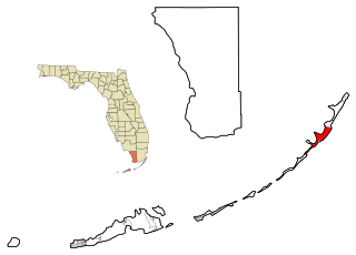
Key Largo is an unincorporated area and census-designated place in Monroe County, Florida, United States, located on the island of Key Largo in the upper Florida Keys. The population was 12,447 at the 2020 census, up from 10,433 in 2010. The name comes from the Spanish Cayo Largo, or "long key". It is both the first island and town of the Florida Keys to be reached from the Overseas Highway to Key West. It was also the location of one of the stations of the Overseas Railroad.
Waukeenah is an unincorporated community and census-designated place (CDP) in Jefferson County, Florida, United States. As of the 2020 census, the population was 259.
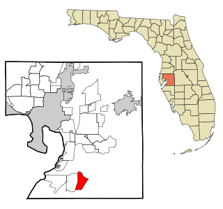
Rio Pinar is a census-designated place and unincorporated area in Orange County, Florida, United States. The population was 5,211 at the 2010 census. It is part of the Orlando–Kissimmee Metropolitan Statistical Area and is home to the private Rio Pinar Country Club.
Grenelefe is an unincorporated community and census-designated place located in Polk County, Florida, United States. Its population was 2,495 as of the 2020 census.
Garcon Point is an unincorporated community and census-designated place in Santa Rosa County, Florida, United States. Its population was 457 as of the 2020 census. The community is located on the peninsula of the same name.

Avalon is an unincorporated community and census-designated place in Santa Rosa County, Florida, United States. Its population was 679 as of the 2010 census. Interstate 10 passes through the community.
Brownsdale is an unincorporated community and census-designated place in Santa Rosa County, Florida, United States. Its population was 471 as of the 2010 census.
Dickerson City is an unincorporated community and census-designated place in Santa Rosa County, Florida, United States. Its population was 146 as of the 2010 census. The community is located on the eastern side of Garcon Point.
Holley is an unincorporated community and census-designated place in Santa Rosa County, Florida, United States. Its population was 1,630 as of the 2010 census. Florida State Road 87 passes through the community.
Mount Carmel is an unincorporated community and census-designated place in Santa Rosa County, Florida, United States. Its population was 227 as of the 2010 census. Florida State Road 89 passes through the community.
Mulat is an unincorporated community and census-designated place in Santa Rosa County, Florida, United States. Its population was 259 as of the 2010 census.
Point Baker is an unincorporated community and census-designated place in Santa Rosa County, Florida, United States. Its population was 2,991 as of the 2010 census. Florida State Road 87 and Florida State Road 89 intersect in Point Baker.
Fuller Heights is an unincorporated community and census-designated place in Polk County, Florida, United States. Its population was 10,467 as of the 2020 census.
Fidelis is an unincorporated community and census-designated place in Santa Rosa County, Florida, United States. Its population was 156 as of the 2010 census. Florida State Road 87 passes through the community.


