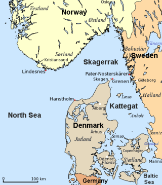
The Kattegat is a 30,000 km2 (12,000 sq mi) sea area bounded by the Jutlandic peninsula in the west, the Danish Straits islands of Denmark and the Baltic Sea to the south and the provinces of Bohuslän, Västergötland, Halland and Skåne in Sweden in the east. The Baltic Sea drains into the Kattegat through the Danish Straits. The sea area is a continuation of the Skagerrak and may be seen as a bay of the North Sea, but in traditional Scandinavian usage, this is not the case.

Øresund or Öresund, commonly known in English as the Sound, is a strait which forms the Danish–Swedish border, separating Zealand (Denmark) from Scania (Sweden). The strait has a length of 118 kilometres (73 mi); its width varies from 4 kilometres (2.5 mi) to 28 kilometres (17 mi). It is 4 kilometres (2.5 mi) wide at its narrowest point between Helsingør in Denmark and Helsingborg in Sweden.

Höganäs Municipality is one of 290 municipalities of Sweden, in Skåne County in the southern part of the country. Its seat is located in the city of Höganäs.

Halland is one of the traditional provinces of Sweden (landskap), on the western coast of Götaland, southern Sweden. It borders Västergötland, Småland, Scania and the sea of Kattegat. Until 1645 and the Second Treaty of Brömsebro, it was part of the Kingdom of Denmark. Its name means Land of Rocky Slabs referring to the coastal cliffs of the region.

Västergötland, also known as West Gothland or the Latinized version Westrogothia in older literature, is one of the 25 traditional non-administrative provinces of Sweden, situated in the southwest of Sweden.
The Skagerrak is a strait running between the Jutland peninsula of Denmark, the southeast coast of Norway and the west coast of Sweden, connecting the North Sea and the Kattegat sea.

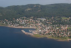
Arild is a locality situated in Höganäs Municipality, Skåne County, Sweden with 522 inhabitants in 2010. It is located in the bay of Skälderviken in north-western Scania, approximately 30 km north of Helsingborg in Sweden. Arild belongs to Brunnby parish with its seat in Brunnby. The parish is represented in Arild by Arilds Chapel. The village was mostly concentrated around the chapel and the shoreline but has come to extend uphill towards Kullaberg, creating height differences between the various parts of the village. The coastline surrounding the village and the majority of the northern shore of the Kullen peninsula is mountainous.

Simrishamn is a locality and the seat of Simrishamn Municipality, Skåne County, Sweden with 6,527 inhabitants in 2010. Despite its small population, Simrishamn is, for historical reasons, usually still referred to as a city.

Ulricehamn is a locality and the seat of Ulricehamn Municipality, Västra Götaland County, Sweden, with 9,787 inhabitants in 2010.

Skanör med Falsterbo is a statistical locality, situated in Vellinge Municipality, Skåne County, Sweden with 6,937 inhabitants in 2010. It consists of the two old towns of Skanör and Falsterbo which have grown together and were unified in 1754, but are still regarded as different communities by locals. The preposition med means with. Thanks to its southerly and maritime position, the locality is the mildest in Sweden, with winter lows barely averaging frosts.

Anholt is a Danish island in the Kattegat, midway between Jutland and Sweden at the entrance to the North Sea in Northern Europe. There are 150 permanent residents as of 1 January 2022. Anholt is seven mi (11 km) long and about four mi (6.4 km) wide at its widest, and covers an area of 21.75 km2 (8.40 sq mi). Anholt is part of Norddjurs Municipality in Region Midtjylland. Before the 2007 municipal reform, it was in Grenå Municipality.

Styrsö is a small island and a locality situated in Göteborg Municipality, Västra Götaland County, Sweden. It had 1,304 inhabitants in 2010.

Kullaberg is a peninsula and nature reserve of land protruding into the Kattegat in Höganäs Municipality near the town of Mölle in southwest Sweden. The site in the province of Skåne is an area of considerable biodiversity supporting a number of rare species and has been designated as an Important Bird Area (IBA) in Sweden as well as a Special Protection Area (SPA). The terrain is dominated by steep cliffs rising from the sea and rocky outcrops on the ridge above, the highest elevation being Håkull at 188 metres. Ridgetop vegetation includes a mixed hardwood broadleaf forest consisting of birch, beech, oak and pine trees with an understory of hawthorn, juniper, wild honeysuckle and blackthorn. Among the notable rare plants are spring vetchling, Lathyrus sphaericus.

The Kullen Lighthouse is an operational lighthouse in Scania, located by the mouth of Öresund, at the point of Kullaberg peninsula, in Höganäs, on the south-west coast of Sweden. Kullen is one of the most prominent landmarks along the Swedish coastline, and with its 1000 Watt electric bulb in a huge lenshouse, also the most powerful lighthouse in Scandinavia, overlooking one of the world's most heavily traveled waters.

Scania, also known by its native name of Skåne, is the southernmost of the historical provinces of Sweden. Located in the south tip of the geographical region of Götaland, the province is roughly conterminous with Skåne County, created in 1997. Like the other former provinces of Sweden, Scania still features in colloquial speech and in cultural references, and can therefore not be regarded as an archaic concept. Within Scania there are 33 municipalities that are autonomous within the Skåne Regional Council. Scania's largest city, Malmö, is the third-largest city in Sweden, as well as the fifth-largest in Scandinavia.
David Sigurd Wallin was a Swedish artist. He grew up in Stockholm.
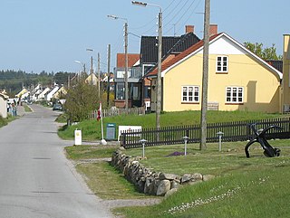
Bønnerup Strand is a village in Norddjurs Municipality, Denmark.

Nakkehoved Lighthouse was originally the name for two individual lighthouses above the namesake Nakkehoved cliffs, between Gilleleje and Hornbæk, approximately 40 km north of Copenhagen, Denmark. Since the eastern lighthouse was decommissioned in 1898, the name Nakkehoved lighthouse has come to refer to only the western tower, which is still operational. The eastern lighthouse was listed on the Danish registry of protected buildings and places in 1976. The western lighthouse was also listed on the registry in 2002.
Mölle Golf Club is a golf club located on the Kullen peninsula in Höganäs Municipality, southwestern Sweden. It has hosted the Höganäs Ladies Open on the Ladies European Tour.

Skälder Bay is a bay in Skåne County, Sweden. It is an inlet of the Kattegat on the western coast of Scania, located between the Bjäre Peninsula to the north and the Kullen Peninsula to the south. The town of Ängelholm is located at the head of the bay.