Naracoorte Coastal Plain (biogeographic region)

Last updated

The IBRA regions, with Naracoorte Coastal Plain in red IBRA 6.1 Naracoorte Coastal Plain.png
The IBRA regions, with Naracoorte Coastal Plain in red

Naracoorte Coastal Plain is an interim Australian bioregion located in the southeast of South Australia. [1] [2]

Interim Biogeographic Regionalisation for Australia biogeographic regionalisation of Australia developed by the Australian Government

The Interim Biogeographic Regionalisation for Australia (IBRA) is a biogeographic regionalisation of Australia developed by the Australian Government's Department of Sustainability, Environment, Water, Population and Communities. It was developed for use as a planning tool, for example for the establishment of a National Reserve System.

A bioregion is an ecologically and geographically defined area that is smaller than an ecozone, but larger than an ecoregion or an ecosystem, in the World Wildlife Fund classification scheme. There is also an attempt to use the term in a rank-less generalist sense, similar to the terms "biogeographic area" or "biogeographic unit".

South Australia State of Australia

South Australia is a state in the southern central part of Australia. It covers some of the most arid parts of the country. With a total land area of 983,482 square kilometres (379,725 sq mi), it is the fourth-largest of Australia's states and territories by area, and fifth largest by population. It has a total of 1.7 million people, and its population is the second most highly centralised in Australia, after Western Australia, with more than 77 percent of South Australians living in the capital, Adelaide, or its environs. Other population centres in the state are relatively small; Mount Gambier, the second largest centre, has a population of 28,684.

Contents

See also

Related Research Articles

Hampton (biogeographic region) biogeographic region

Hampton is an interim Australian bioregion, that is located in Western Australia.

Murchison (biogeographic region) IBRA in Western Australia

Murchison is an Interim Biogeographic Regionalisation for Australia (IBRA) region in Western Australia and part of the Western Australian Mulga shrublands ecoregion.

Northern Kimberley Region in Western Australia

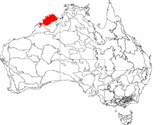
The Northern Kimberley, an interim Australian bioregion, is located in the northern Kimberley region of Western Australia, comprising 8,420,100 hectares.

Victoria Bonaparte Region in Australia

The Victoria Bonaparte, an interim Australian bioregion, is located in the Northern Territory and Western Australia, comprising 7,301,242 hectares.

New England Tablelands (biogeographic region) Region in Australia

New England Tablelands ,an interim Australian bioregion, is located mainly in New South Wales, comprising 3,002,213 hectares, of which 2,860,758 hectares or 95.23 per cent of the bioregion lies within New South Wales; and the residual within Queensland. This bioregion is one of the smaller bioregions in NSW, occupying 3.57 per cent of the state.

New South Wales North Coast Region in New South Wales, Australia

New South Wales North Coast or NSW North Coast, an interim Australian bioregion, is located in New South Wales, comprising 3,996,591 hectares.

Mitchell Grass Downs Region in Australia

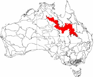
The Mitchell Grass Downs (MGD) is an IBRA biogeographic region, located in the Northern Territory and Queensland, which comprises an area of 33,468,761 hectares with eight subregions.

Arnhem Coast Region in the Northern Territory, Australia

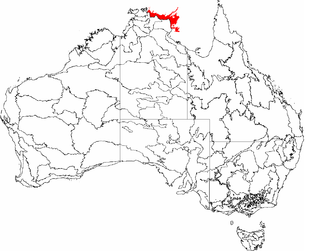
The Arnhem Coast, an interim Australian bioregion, is located in the Northern Territory, comprising an area of 3,335,669 hectares of the coastal plains that characterises central Arnhem Land in the Top End of the Northern Territory.

Darwin Coastal Region in the Northern Territory, Australia

The Darwin Coastal, an IBRA bioregion, is located in the Northern Territory of Australia.

Nandewar Region in Australia

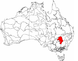
Nandewar, an interim Australian bioregion, is located in New South Wales and Queensland, and comprises an area of 2,701,977 hectares, surrounded by the Brigalow Belt South to the west, south-west and north-west, and to the east by the New England Tablelands. This is a region of hills on Palaeozoic sediments and lithosols and of Eucalyptus albens woodlands and summer rainfall.

Pine Creek (biogeographic region) Region in the Northern Territory, Australia

The Pine Creek biogeographic region, an interim Australian bioregion, is located in the Northern Territory, and comprises 2,851,777 hectares.

Gulf Coastal Region in the Northern Territory, Australia

The Gulf Coastal, an interim Australian bioregion, is located in the Northern Territory, comprising 2,711,718 hectares.

Gulf Fall and Uplands Region in Australia

The Gulf Fall and Uplands, an interim Australian bioregion, is located in the Northern Territory andQueensland, comprising 11,847,909 hectares.

Gulf Plains Region in Australia

The Gulf Plains, an interim Australian bioregion, is located in the Northern Territory, comprising 22,041,825 hectares.

Mount Isa Inlier Region in Queensland, Australia

Mount Isa Inlier, an interim Australian bioregion, is located in the Queensland, and comprises 6,778,263 hectares.

Central Mackay Coast Region in Queensland, Australia

Central Mackay Coast, an interim Australian bioregion, is located in Queensland, and comprises 1,464,208 hectares.

Cobar Peneplain Region in Queensland, Australia

Cobar Peneplain, an interim Australian bioregion, is located in New South Wales, and comprises 7,385,346 hectares.

Stony Plains Region in Australia

Stony Plains, an interim Australian bioregion, comprises 13,166,372 hectares, and is part of two state/territories of Australia: the Northern Territory and South Australia.

Tanami (IBRA region) Region in Australia

The Tanami , an interim Australian bioregion, comprises 25,997,277 hectares, and is part of twostate/territories of Australia: the Northern Territory and Western Australia.

References

  1. Environment Australia. "Revision of the Interim Biogeographic Regionalisation for Australia (IBRA) and Development of Version 5.1 - Summary Report". Department of the Environment and Water Resources, Australian Government. Archived from the original on 5 September 2006. Retrieved 31 January 2007.
  2. IBRA Version 6.1 data

Further reading

International Standard Book Number Unique numeric book identifier

The International Standard Book Number (ISBN) is a numeric commercial book identifier which is intended to be unique. Publishers purchase ISBNs from an affiliate of the International ISBN Agency.

Coordinates: 36°57′03″S140°13′45″E / 36.950830°S 140.229055°E / -36.950830; 140.229055

Geographic coordinate system Coordinate system

A geographic coordinate system is a coordinate system that enables every location on Earth to be specified by a set of numbers, letters or symbols. The coordinates are often chosen such that one of the numbers represents a vertical position and two or three of the numbers represent a horizontal position; alternatively, a geographic position may be expressed in a combined three-dimensional Cartesian vector. A common choice of coordinates is latitude, longitude and elevation. To specify a location on a plane requires a map projection.