Carnarvon (biogeographic region)

Last updated

The IBRA regions, with Carnarvon in red IBRA 6.1 Carnarvon.png
The IBRA regions, with Carnarvon in red

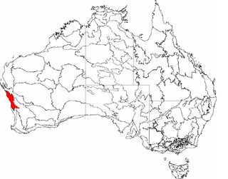
Carnarvon is an Australian bioregion in Western Australia. [1] [2] This area is also referred to physiographically as the Carnarvon Basin, where it is a physiographic province of the larger West Australian Shield division.

A bioregion is an ecologically and geographically defined area that is smaller than an ecozone, but larger than an ecoregion or an ecosystem, in the World Wildlife Fund classification scheme. There is also an attempt to use the term in a rank-less generalist sense, similar to the terms "biogeographic area" or "biogeographic unit".

Western Australia State in Australia

Western Australia is a state occupying the entire western third of Australia. It is bounded by the Indian Ocean to the north and west, and the Southern Ocean to the south, the Northern Territory to the north-east, and South Australia to the south-east. Western Australia is Australia's largest state, with a total land area of 2,529,875 square kilometres, and the second-largest country subdivision in the world, surpassed only by Russia's Sakha Republic. The state has about 2.6 million inhabitants – around 11 percent of the national total – of whom the vast majority live in the south-west corner, 79 per cent of the population living in the Perth area, leaving the remainder of the state sparsely populated.

The Carnarvon Basin is a geological basin located in the north west of Western Australia. This is the main geological feature that makes up the North West Shelf. The onshore part of the Carnarvon Basin covers about 115,000 km² and the offshore part covers approximately 535,000 km² with water depths up to 3,500 metres. It is separated into two major areas - the Northern Carnarvon Basin, and the Southern Carnarvon Basin.

It has two sub regions:

Related Research Articles

Avon Wheatbelt Bioregion

The Avon Wheatbelt is an Australian bioregion in Western Australia and part of the larger Southwest Australia savanna ecoregion.

Geraldton Sandplains

Geraldton Sandplains is an interim Australian bioregion of Western Australia and part of the larger Southwest Australia savanna ecoregion, as assessed by the World Wildlife Fund.

Northern Kimberley Region in Western Australia

The Northern Kimberley, an interim Australian bioregion, is located in the northern Kimberley region of Western Australia, comprising 8,420,100 hectares.

Victoria Bonaparte Region in Australia

The Victoria Bonaparte, an interim Australian bioregion, is located in the Northern Territory and Western Australia, comprising 7,301,242 hectares.

Yalgoo (biogeographic region) biogeographic region in Western Australia

Yalgoo is an interim Australia bioregion located in Western Australia, comprising 5,087,577 hectares.

Dampierland

Dampierland is an interim Australian bioregion in Western Australia. The region is also a distinct physiographic section of the larger Nullagine Platform province, which in turn is part of the larger West Australian Shield division.

New England Tablelands (biogeographic region) Region in Australia

New England Tablelands ,an interim Australian bioregion, is located mainly in New South Wales, comprising 3,002,213 hectares, of which 2,860,758 hectares or 95.23 per cent of the bioregion lies within New South Wales; and the residual within Queensland. This bioregion is one of the smaller bioregions in NSW, occupying 3.57 per cent of the state.

New South Wales North Coast Region in New South Wales, Australia

New South Wales North Coast or NSW North Coast, an interim Australian bioregion, is located in New South Wales, comprising 3,996,591 hectares.

Tasmanian West Region in Tasmania, Australia

Tasmanian West is an interim Australian bioregion located in the western region of Tasmania, comprising 1,565,077 hectares.

Pine Creek (biogeographic region) Region in the Northern Territory, Australia

The Pine Creek biogeographic region, an interim Australian bioregion, is located in the Northern Territory, and comprises 2,851,777 hectares.

Gulf Coastal Region in the Northern Territory, Australia

The Gulf Coastal, an interim Australian bioregion, is located in the Northern Territory, comprising 2,711,718 hectares.

Gulf Fall and Uplands Region in Australia

The Gulf Fall and Uplands, an interim Australian bioregion, is located in the Northern Territory andQueensland, comprising 11,847,909 hectares.

Gulf Plains Region in Australia

The Gulf Plains, an interim Australian bioregion, is located in the Northern Territory, comprising 22,041,825 hectares.

Simpson Strzelecki Dunefields Region in Australia

The Simpson Strzelecki Dunefields, an interim Australian bioregion, comprises 27,984,283 hectares, and is part of four state/territories of Australia: the Northern Territory, South Australia, New South Wales and Queensland

Mount Isa Inlier Region in Queensland, Australia

Mount Isa Inlier, an interim Australian bioregion, is located in the Queensland, and comprises 6,778,263 hectares.

Central Mackay Coast Region in Queensland, Australia

Central Mackay Coast, an interim Australian bioregion, is located in Queensland, and comprises 1,464,208 hectares.

Cobar Peneplain Region in Queensland, Australia

Cobar Peneplain, an interim Australian bioregion, is located in New South Wales, and comprises 7,385,346 hectares.

Finke (biogeographic region) Region in Australia

Finke, an interim Australian bioregion, comprises 7,267,416 hectares, and is part of two state/territories of Australia: the Northern Territory and South Australia.

Stony Plains Region in Australia

Stony Plains, an interim Australian bioregion, comprises 13,166,372 hectares, and is part of two state/territories of Australia: the Northern Territory and South Australia.

Tanami (IBRA region) Region in Australia

The Tanami , an interim Australian bioregion, comprises 25,997,277 hectares, and is part of twostate/territories of Australia: the Northern Territory and Western Australia.

References

  1. Environment Australia. "Revision of the Interim Biogeographic Regionalisation for Australia (IBRA) and Development of Version 5.1 - Summary Report". Department of the Environment and Water Resources, Australian Government. Archived from the original on 5 September 2006. Retrieved 31 January 2007.
  2. IBRA Version 6.1 Archived September 8, 2006, at the Wayback Machine data
  3. Western Australia. Dept. of Environment and Conservation. (2007)Shark Bay terrestrial reserves and proposed reserve additions : draft management plan 2007 Department of Environment and Conservation ; Conservation Commission of Western Australia. Bentley, W.A.: Dept. of Environment and Conservation. pages 37-39 section Bioregions and Figure 4: IBRA sub-regions of the Shark Bay Area (map)

Further reading

International Standard Book Number Unique numeric book identifier

The International Standard Book Number (ISBN) is a numeric commercial book identifier which is intended to be unique. Publishers purchase ISBNs from an affiliate of the International ISBN Agency.