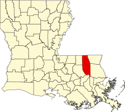
Natalbany, Louisiana | |
---|---|
Coordinates: 30°32′55″N90°29′42″W / 30.54861°N 90.49500°W [1] | |
Country | United States |
State | Louisiana |
Parish | Tangipahoa |
Area | |
• Total | 4.47 sq mi (11.58 km2) |
• Land | 4.43 sq mi (11.46 km2) |
• Water | 0.04 sq mi (0.11 km2) |
Elevation | 56 ft (17 m) |
Population (2020) | |
• Total | 2,510 |
• Density | 567.10/sq mi (218.97/km2) |
Time zone | UTC-6 (CST) |
• Summer (DST) | UTC-5 (CDT) |
Area code | 985 |
FIPS code | 22-53475 |
GNIS feature ID | 2403328 [1] |
Natalbany is a census-designated place (CDP) in Tangipahoa Parish, Louisiana, United States. The population was 1,739 at the 2000 census. It is part of the Hammond MSA.
The community is named after the nearby Natalbany River. It is speculated that the name of the river is derived from the Choctaw words nita meaning bear and abani which means "to cook over a fire" in the Choctaw language. [3]
According to the United States Census Bureau, the CDP has a total area of 4.5 square miles (12 km2), of which 4.4 square miles (11 km2) is land and 0.1 square miles (0.26 km2) (1.56%) is water (including Ponchatoula Creek).
Census | Pop. | Note | %± |
---|---|---|---|
2020 | 2,510 | — | |
U.S. Decennial Census [4] |
Race | Number | Percentage |
---|---|---|
White (non-Hispanic) | 1,154 | 45.98% |
Black or African American (non-Hispanic) | 1,030 | 41.04% |
Native American | 13 | 0.52% |
Asian | 19 | 0.76% |
Other/Mixed | 81 | 3.23% |
Hispanic or Latino | 213 | 8.49% |
As of the 2020 United States census, there were 2,510 people, 1,130 households, and 553 families residing in the CDP.
Prien is an unincorporated community and census-designated place (CDP) in Calcasieu Parish, Louisiana, United States. The population was 7,810 at the 2010 census. It is part of the Lake Charles metropolitan statistical area. Some of the area has been annexed into the city of Lake Charles.
Barataria is a census-designated place (CDP) in Jefferson Parish, Louisiana, United States. The population was 1,057 in 2020. It is part of the New Orleans–Metairie–Kenner metropolitan statistical area.
Albany is a town in eastern Livingston Parish, Louisiana, United States. The population was 1,088 at the 2010 census and 1,235 in 2020. It is part of the Baton Rouge metropolitan statistical area.
Meraux is a census-designated place (CDP) in St. Bernard Parish, Louisiana, United States. The population was 6,804 in 2020. It is part of the New Orleans–Metairie–Kenner Metropolitan Statistical Area.
Poydras is a census-designated place (CDP) in St. Bernard Parish, Louisiana, United States. The population was 3,886 at the 2000 census and 2,536 in 2020. It is part of the New Orleans–Metairie–Kenner Metropolitan Statistical Area. Poydras is on the East Bank of the Mississippi River, just upriver from the Plaquemines Parish line.
Violet is a census-designated place (CDP) in St. Bernard Parish, Louisiana, United States. The population was 5,758 at the 2020 census. Violet is located on the east bank of the Mississippi River, approximately 7.5 miles (12.1 km) southeast of New Orleans and is part of the New Orleans–Metairie–Kenner metropolitan statistical area.
Hahnville is a census-designated place (CDP) in and the parish seat of St. Charles Parish, Louisiana, United States. The population was 2,792 at the 2000 census and 2,959 in 2020. It was founded by former governor Michael Hahn.
Taft is a census-designated place (CDP) in St. Charles Parish, Louisiana, United States, located on the west bank of the Mississippi River.
Amelia is a census-designated place (CDP) in St. Mary Parish, Louisiana, United States. The population was 2,459 at the 2010 census. It is part of the Morgan City Micropolitan Statistical Area.
Redwater is a census-designated place (CDP) in Leake County, Mississippi, United States. It is one of the eight communities of the Mississippi Band of Choctaw Indians Reservation, and the population is 61% Choctaw. The population was 633 at the 2010 census, up from 409 at the 2000 census.
Standing Pine is a census-designated place (CDP) in Leake County, Mississippi, United States. It is one of the eight communities of the Mississippi Band of Choctaw Indians Reservation, and the population is 94% Choctaw. The total population of the CDP was 517 at the 2020 census.
Pearl River is a census-designated place (CDP) in Neshoba County, Mississippi. It is one of the eight communities of the Mississippi Band of Choctaw Indians Reservation and the population is 80% Choctaw. The population was 3,156 at the 2000 census.
Tucker is a census-designated place (CDP) in Neshoba County, Mississippi. It is one of the eight communities of the Mississippi Band of Choctaw Indians Reservation and the population is 93% Choctaw. The population was 642 at the 2020 census.
Conehatta is a census-designated place (CDP) in Newton County, Mississippi. The population was 1376 at the 2020 census. It is one of the eight communities included in the Mississippi Band of Choctaw Indians Reservation and the population is 76% Choctaw.
Bogue Chitto is an unincorporated community and census-designated place (CDP) in Lincoln County, Mississippi, United States. As of the 2020 census, it had a population of 437. Bogue Chitto is the only municipal hamlet in the state of Mississippi.
Milton is an unincorporated community and census-designated place in Lafayette Parish, Louisiana, United States. At the 2010 U.S. census it had a population of 3,030; at the 2019 American Community Survey, it had an estimated population of 2,299. Milton is part of the Lafayette metropolitan statistical area.
Nanafalia is an unincorporated community and census-designated place (CDP) in Marengo County, Alabama, United States. As of the 2020 census, its population was 75, down from 94 at the 2010 census. The community is located on a ridge above the Tombigbee River, and the name is derived from the Choctaw words for long hill. Nanafalia has a post office with a zip code of 36764.
Bayou Goula is an unincorporated community and census-designated place (CDP) in Iberville Parish, Louisiana, United States. Its population was 514 in 2020.
Hester is an unincorporated community and census-designated place in St. James Parish, Louisiana, United States. It was first listed as a CDP in the 2010 census with a population of 498. The community is located along Louisiana Highway 44 on the east bank of the Mississippi River.
Crescent is an unincorporated community and census-designated place in Iberville Parish, Louisiana, United States. It was first listed as a CDP in the 2010 Census with a population of 959. In 2020, its population was 811.