List of the National Register of Historic Places listings in Ocean County, New Jersey
| Atlantic – Bergen (Closter, Franklin Lakes, Ridgewood, Saddle River, Wyckoff) – Burlington – Camden – Cape May – Cumberland – Essex – Gloucester – Hudson – Hunterdon – Mercer – Middlesex – Monmouth – Morris – Ocean – Passaic – Salem – Somerset – Sussex – Union – Warren |
This is intended to be a complete list of properties and districts listed on the National Register of Historic Places in Ocean County, New Jersey. Latitude and longitude coordinates of the sites listed on this page may be displayed in an online map. [1]
This National Park Service list is complete through NPS recent listings posted July 26, 2024. [2]
| [3] | Name on the Register [4] | Image | Date listed [5] | Location | City or town | Description |
|---|---|---|---|---|---|---|
| 1 | Barnegat Light Public School |  | June 7, 1976 (#76001178) | 501 Central Ave. 39°45′35″N74°06′20″W / 39.759722°N 74.105556°W | Barnegat Light | |
| 2 | Barnegat Lighthouse |  | January 25, 1971 (#71000512) | North end of Long Beach Island, off Broadway Ave. 39°45′51″N74°06′23″W / 39.764167°N 74.106389°W | Barnegat Light | |
| 3 | Bartlett-Rockhill-Bartlett House |  | January 20, 2012 (#11001041) | Bartlett Ln. 39°36′04″N74°20′35″W / 39.601164°N 74.343167°W | Tuckerton | |
| 4 | Bay Head Historic District |  | February 1, 2006 (#05001566) | Roughly bounded by Point Pleasant Beach Borough line, Atlantic Ocean, Mantoloking Borough line and Point Pleasant 40°04′18″N74°02′51″W / 40.071667°N 74.0475°W | Bay Head | |
| 5 | Beach Haven Historic District |  | July 14, 1983 (#83001608) | Roughly bounded by Bay and Atlantic Avenues, Pearl and 3rd Streets; later roughly bounded by Atlantic, Bay, 5th and Chatsworth 39°33′32″N74°14′31″W / 39.558889°N 74.241944°W | Beach Haven | Second set of addresses represents a boundary increase November 19, 2014. Also includes Converse Cottage and Dr. Edward H. Williams House |
| 6 | Captain Amos Birdsall House | 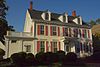 | May 13, 1982 (#82003298) | 234 Washington Street 39°57′09″N74°11′28″W / 39.9525°N 74.191111°W | Toms River | Part of Old Village of Toms River MRA, destroyed by fire May 31, 2016 |
| 7 | A. A. Brant House |  | May 13, 1982 (#82003294) | 9 Allen Street 39°57′04″N74°11′43″W / 39.951111°N 74.195278°W | Toms River | Part of Old Village of Toms River MRA |
| 8 | Cassville Crossroads Historic District |  | August 26, 1982 (#82003291) | Junction of CR 571 and CR 528 40°06′17″N74°23′14″W / 40.104722°N 74.387222°W | Jackson Township | |
| 9 | Cavalry Cottage | 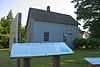 | September 22, 2006 (#06000871) | 100 Stafford Ave. 39°41′50″N74°15′19″W / 39.697222°N 74.255278°W | Stafford Township | |
| 10 | Cedar Bridge Tavern |  | August 7, 2013 (#13000586) | 200 Old Halfway Rd. [6] 39°47′00″N74°21′38″W / 39.783333°N 74.360556°W | Barnegat Township | |
| 11 | Converse Cottage |  | July 14, 1983 (#83001609) | 500 South Atlantic Avenue 39°33′32″N74°14′23″W / 39.55875°N 74.239722°W | Beach Haven | Part of Beach Haven MRA |
| 12 | Mary Etta Cox House |  | March 9, 2005 (#05000124) | 353 North Main Street 39°45′13″N74°13′26″W / 39.753611°N 74.223889°W | Barnegat Township | |
| 13 | Crawford House | 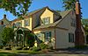 | May 13, 1982 (#82003295) | 46 East Water Street 39°57′03″N74°11′46″W / 39.950833°N 74.196111°W | Toms River | Part of Old Village of Toms River MRA |
| 14 | Double Trouble Historic District |  | February 23, 1978 (#78001787) | S of Beachwood off Garden State Pkwy. 39°53′51″N74°13′37″W / 39.8975°N 74.226944°W | Bayville | |
| 15 | Falkinburg Farmstead |  | August 12, 1993 (#93000829) | 28 Westcott Avenue, Waretown 39°47′03″N74°11′35″W / 39.784167°N 74.193056°W | Ocean Township | |
| 16 | Elizabeth Sculthorp Force House |  | February 4, 2019 (#100003403) | 26 Hadley Avenue 39°57′10″N74°11′28″W / 39.952889°N 74.191111°W | Toms River | Also known as Pierson–Sculthorp House, Ocean County Historical Society |
| 17 | Georgian Court |  | December 20, 1978 (#78001788) | Lakewood Avenue 40°05′52″N74°13′37″W / 40.097778°N 74.226944°W | Lakewood | Also known as George Jay Gould Estate |
| 18 | Captain George W. Giberson House | 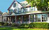 | August 12, 1982 (#82004693) | 54 East Water Street 39°57′03″N74°11′46″W / 39.950833°N 74.196111°W | Toms River | Part of Old Village of Toms River MRA |
| 19 | Hangar No. 1, Lakehurst Naval Air Station | 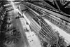 | May 23, 1968 (#68000031) | N of Lakehurst on CR 547 40°01′44″N74°18′59″W / 40.028889°N 74.316389°W | Manchester Township | |
| 20 | Horner House |  | May 13, 1982 (#82003296) | 44 East Water Street 39°57′04″N74°11′47″W / 39.9511°N 74.1964°W | Toms River | Part of Old Village of Toms River MRA |
| 21 | L. Ron Hubbard Residence at Bay Head |  | May 17, 2018 (#100001777) | 666 East Avenue 40°03′50″N74°02′40″W / 40.0640°N 74.0444°W | Bay Head | L. Ron Hubbard House |
| 22 | Island Heights Historic District |  | July 8, 1982 (#82003290) | Roughly bounded by Toms River, Summit and River Avenues 39°56′26″N74°08′43″W / 39.9406°N 74.1453°W | Island Heights | |
| 23 | Little Egg Harbor Friends Meeting House |  | December 9, 2002 (#02001511) | 21 E. Main St. 39°36′12″N74°20′29″W / 39.6033°N 74.3414°W | Tuckerton | |
| 24 | Manahawkin Baptist Church | 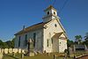 | April 3, 1973 (#73001131) | N. Main St. (US 9) and Lehigh Ave. 39°41′55″N74°15′29″W / 39.6986°N 74.2581°W | Manahawkin | |
| 25 | Manitou Park School House |  | March 15, 2005 (#05000177) | 167 Third Ave. 39°56′48″N74°13′03″W / 39.9467°N 74.2175°W | Berkeley | |
| 26 | Ocean County Courthouse |  | August 16, 1983 (#83001610) | Washington Street 39°57′10″N74°11′41″W / 39.9528°N 74.1947°W | Toms River | Part of Old Village of Toms River MRA |
| 27 | Ocean County Jail |  | August 16, 1983 (#83001611) | Sheriff Street 39°57′12″N74°11′41″W / 39.953333°N 74.194806°W | Toms River | Part of Old Village of Toms River MRA, demolished |
| 28 | Old Coast Guard Station Manasquan Inlet |  | May 14, 2021 (#100006508) | 40 Inlet Drive 40°06′10″N74°02′15″W / 40.10275°N 74.037556°W | Point Pleasant Beach | Also known as Coast Guard Lifeboat Station #105 |
| 29 | Orient Baptist Church |  | August 10, 1977 (#77000902) | NJ 88, Laurelton 40°04′11″N74°07′40″W / 40.0697°N 74.1278°W | Brick Township | Also known as the First Baptist Church of Laurelton |
| 30 | Stewart House |  | May 13, 1982 (#82003297) | 57 East Water Street 39°57′03″N74°11′46″W / 39.9508°N 74.1961°W | Toms River | Part of Old Village of Toms River MRA |
| 31 | Stoutenburgh–Minturn House |  | May 13, 1982 (#82003293) | 86 East Water Street 39°57′03″N74°11′35″W / 39.950833°N 74.193056°W | Toms River | Part of Old Village of Toms River MRA |
| 32 | Strand Theatre |  | April 22, 1982 (#82003292) | 400 Clifton Ave. 40°05′39″N74°12′57″W / 40.0942°N 74.2158°W | Lakewood | |
| 33 | Torrey-Larrabee Store |  | February 21, 1997 (#97000104) | 11 Union Ave. 40°06′09″N74°18′34″W / 40.1025°N 74.3094°W | Lakehurst | |
| 34 | U.S. Life Saving Station Station No. 14 |  | January 30, 1978 (#78001789) | S of Seaside Park on Island Beach State Park 39°56′01″N74°04′17″W / 39.9336°N 74.0714°W | Seaside Park | |
| 35 | Whitesbog Historic District |  | October 27, 1988 (#88002115) | N of SR 70 and S of Fort Dix 39°57′36″N74°29′23″W / 39.96°N 74.4897°W | Whiting | Extends into Burlington County |
| 36 | Dr. Edward H. Williams House |  | July 14, 1983 (#83001612) | 506 South Atlantic Avenue 39°33′30″N74°14′24″W / 39.5583°N 74.2400°W | Beach Haven | Part of Beach Haven MRA |