Related Research Articles

Buffalo County is a county located in the U.S. state of Wisconsin. As of the 2020 census, the population was 13,317. Its county seat is Alma. The county was created in 1853 and organized the following year.

Winona County is a county in the U.S. state of Minnesota. As of the 2020 census, its population was 49,671. Its county seat is Winona. Winona County comprises the Winona, MN Micropolitan Statistical Area.

Wabasha County is a county in the U.S. state of Minnesota. As of the 2020 census, the population was 21,387. Its county seat is Wabasha.

Hallock is a city in and the county seat of Kittson County, Minnesota, United States. The population was 906 at the 2020 census.

Wabasha is a city and the county seat of Wabasha County, Minnesota. The population was 2,559 at the time of the 2020 census. It is on the Mississippi River, near its confluence with the Zumbro River.

Agenda is a town in Ashland County in the U.S. state of Wisconsin. The population was 422 at the 2010 census. The unincorporated communities of Holts Landing and Petes Landing are located in the town.

Chippewa is a town in Ashland County in the U.S. state of Wisconsin. The population was 374 at the 2010 census.
The Town of Sioux Creek is located in Barron County in the U.S. state of Wisconsin. The population was 655 at the 2010 census.

Belvidere is a town in Buffalo County in the U.S. state of Wisconsin. The population was 396 at the 2010 census. The unincorporated community of Herold is located in the town.
Buffalo is a town in Buffalo County in the U.S. state of Wisconsin. The population was 705 at the 2010 census. The unincorporated communities of Bluff Siding, East Winona, and Marshland are located in the town.

Buffalo City is a city in Buffalo County in the U.S. state of Wisconsin. The population was 1,023 at the 2010 census.
Maxville is a town in Buffalo County in the U.S. state of Wisconsin. The population was 309 at the 2010 census. The ghost town of Savoy was located in the town.

Milton is a town in Buffalo County in the U.S. state of Wisconsin. The population was 534 at the 2010 census. The unincorporated community of Czechville is located in the town.
The Town of Cooks Valley is located in Chippewa County in the U.S. state of Wisconsin. The population was 805 at the 2010 census, up from 632 at the 2000 census. The town was named after Jacob Cook, who purchased property in the valley in the summer of 1858. A post office was established in 1870 with William Miller as the first postmaster.
Alma is a town in Buffalo County in the U.S. state of Wisconsin. The population was 297 at the 2010 census. The city of Alma is located along the western town line. The unincorporated community of Tell is located in the town.

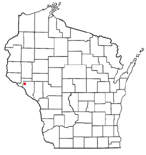
Alma is a city in and the county seat of Buffalo County, Wisconsin, United States. The population was 716 at the 2020 census.
Mondovi is a town in Buffalo County in the U.S. state of Wisconsin. The population was 469 at the 2010 census. The city of Mondovi is located mostly within the town.

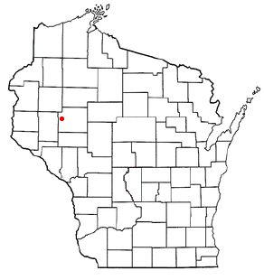
Nelson is a village in Buffalo County in the U.S. state of Wisconsin. The population was 374 at the 2010 census. The village is surrounded by the Town of Nelson.
The Town of Bloomer is located in northwest Chippewa County in the U.S. state of Wisconsin. The population was 1,050 at the 2010 census, up from 926 at the 2000 census. The city of Bloomer is also located in Chippewa County, but to the south of the Town of Bloomer, within the adjacent Town of Woodmohr.

Muscoda is a village in Grant and Iowa counties in the U.S. state of Wisconsin. The population was 1,299 at the 2010 census. Of this, 1,249 were in Grant County and 50 were in Iowa County. The Grant County part of the village is adjacent to the Town of Muscoda and the Iowa County part is adjacent to the Town of Pulaski. Muscoda is the largest village in Grant County.
References
- 1 2 "Geographic Identifiers: 2010 Demographic Profile Data (G001): Nelson town, Buffalo County, Wisconsin". U.S. Census Bureau, American Factfinder. Archived from the original on February 12, 2020. Retrieved May 21, 2014.
- ↑ "U.S. Census website". United States Census Bureau . Retrieved 2008-01-31.
- ↑ 'The Legislative Manual of the State of Wisconsin 1870,' Biographical Sketch of James L. Hallock, pg. 358
Municipalities and communities of Buffalo County, Wisconsin, United States | ||
|---|---|---|
| Cities |  | |
| Villages | ||
| Towns | ||
| CDPs | ||
| Unincorporated communities | ||
| Ghost towns | ||