Nesbyen kommune

Last updated
Nesbyen kommune
Nesbyen, Nes.jpg
Administrative centre of Nesbyen
Nes Buskerud komm.svg
Coat of arms
Norway Buskerud location map.svg
Red pog.svg
Nesbyen kommune
Nesbyen within Buskerud
Norway location map.svg
Red pog.svg
Nesbyen kommune
Nesbyen kommune (Norway)
Coordinates: 60°33′30″N9°6′4″E / 60.55833°N 9.10111°E / 60.55833; 9.10111 Coordinates: 60°33′30″N9°6′4″E / 60.55833°N 9.10111°E / 60.55833; 9.10111
Country Norway
County Buskerud
District Hallingdal
Administrative centre Nesbyen
Government
  Mayor (2015)Tore Haraldset (LL)
Area
  Total810 km2 (310 sq mi)
  Land773 km2 (298 sq mi)
Area rank135 in Norway
Population
 (2004)
  Total3,467
  Rank248 in Norway
  Density4/km2 (10/sq mi)
  Change (10 years)
1.6%
Demonym(s) Nesning [1]
Time zone UTC+01:00 (CET)
  Summer (DST) UTC+02:00 (CEST)
ISO 3166 code NO-0616
Official language form Bokmål [2]
Website www.nes-bu.kommune.no

Nesbyen is a municipality in Viken county, Norway. It is part of the traditional region of Hallingdal. The administrative centre of the municipality is the village of Nesbyen.

Contents

The parish of Næs was established as a municipality on 1 January 1838 (see formannskapsdistrikt). The area of Flå was separated from Nes on 1 January 1905 to become a separate municipality.

General information

Name

The municipality (originally the parish) is named after the old Nes farm (Old Norse: Nesnow the village of Nesbyen), since the first church was built there. The name is identical with the word nes which means headland". Prior to 1889, the name was spelled "Næs".

Coat-of-arms

The coat-of-arms is from modern times. They were granted on 29 June 1979. The arms show a yellow-gold triangle pointing to the left on a red background. This represents a sandy peninsula or headlands (yellow triangle) formed by the confluence of two rivers: Rukkedøla and Hallingdalselva. The design is canting because this is what the name of the municipality means (see above under the name). [3]

Number of minorities (1st and 2nd generation) in Nes by country of origin in 2017 [4]
AncestryNumber
Flag of Poland.svg  Poland 95
Flag of Lithuania.svg  Lithuania 36
Flag of Eritrea.svg  Eritrea 25
Flag of Denmark.svg  Denmark 18
Flag of the Netherlands.svg  Netherlands 17

History

Ancient routes went to Vestlandet through Valdres and Hallingdal and down Røldal to Odda. Reflecting this route, Hallingdal and its neighboring valley of Valdres were originally populated by migrants from Vestlandet and spoke a western dialect. In recognition of this, Cardinal Nicholas Breakespear, who was in Scandinavia as papal legate in 1153, included these two valleys in the diocese of Stavanger. [5]

Geography

The municipality lies in the valley and traditional district of Hallingdal. It is bordered on the north by the municipality of Gol, on the east by Sør-Aurdal, on the southeast by Flå, on the southwest by Nore og Uvdal, and to the west by Ål.

The majority of the residents live in the villages of Nesbyen, Espeset, Eidal, Sjong, Børtnes, Bromma, Svenkerud, and Liodden.

View from Liodden Camping Norway Liodden Camping.jpg
View from Liodden Camping

Attractions

Troymstugua from 1645 Troymstugua, Hallingdal Museum.jpg
Trøymstugua from 1645

Hallingdal Museum (Hallingdal Folkemuseum) is located in Nesbyen. Hallingdal Folk Museum, founded in 1899, is one of the oldest open air museums in Norway. It has a large and unique collection of buildings and artifacts from farms in Hallingdal. Special mentions is houses like Staveloftet, built around 1340, from the Stave farm and Trøymstua from about 1645, coming from Hemsedal.

There is an old meteor crater just north of Nesbyen (about 6 kilometres north and then 4 kilometres into the woods). About 650 million years ago, a 200-to-300-metre (660 to 980 ft) meteorite struck this area. This resulted in a 5-kilometre (3.1 mi) impact crater and an enormous amount of outpouring of energy by the impact.

Notable residents

Related Research Articles

Buskerud County (fylke) of Norway

Buskerud is a traditional region and a former a county in Norway, bordering Akershus, Oslo, Oppland, Sogn og Fjordane, Hordaland, Telemark and Vestfold. The region extends from the Oslofjord and Drammensfjorden in the southeast to Hardangervidda mountain range in the northwest. The county administration was in modern times located in Drammen. Buskerud was merged with Akershus and Østfold into the newly created Viken County on 1 January 2020.

Nore og Uvdal Municipality in Buskerud, Norway

Nore og Uvdal is a municipality in Buskerud county, Norway. It is part of the traditional region of Numedal. The administrative centre of the municipality is the village of Rødberg.

Nes, Akershus Municipality in Akershus, Norway

Nes is a municipality in Akershus county, Norway. It is part of the traditional region of Romerike. The administrative centre of the municipality is the village of Årnes.

Åsnes Municipality in Hedmark, Norway

Åsnes is a municipality in Innlandet county, Norway. It is part of the traditional region of Solør. The administrative centre of the municipality is the village of Flisa, which is also the largest town in the municipality with around 2,100 people.

Sør-Aurdal Municipality in Oppland, Norway

Sør-Aurdal is a municipality in Innlandet county, Norway. It is part of the traditional region of Valdres. The administrative centre of the municipality is the village of Bagn.

Etnedal Municipality in Oppland, Norway

Etnedal is a municipality in Innlandet county, Norway. It is part of the traditional region of Valdres. The administrative centre of the municipality is the village of Bruflat.

Nord-Aurdal Municipality in Oppland, Norway

Nord-Aurdal is a municipality in Innlandet county, Norway. It is part of the traditional region of Valdres. The administrative centre of the municipality is the village of Fagernes.

Vestre Slidre Municipality in Oppland, Norway

Vestre Slidre is a municipality in Innlandet county, Norway. It is part of the traditional region of Valdres. The administrative centre of the municipality is the village of Slidre. The old municipality of Slidre was divided into Vestre Slidre and Øystre Slidre in 1849.

Øystre Slidre Municipality in Oppland, Norway

Øystre Slidre is a municipality in Innlandet county, Norway. It is part of the traditional region of Valdres. The administrative centre of the municipality is the town of Heggenes.

Vang, Oppland Municipality in Oppland, Norway

Vang is a municipality in Innlandet county, Norway. It is part of the traditional region of Valdres. The administrative centre of the municipality is the village of "Vang i Valdres". The municipality of Vang was established on 1 January 1838.

Eidfjord Municipality in Hordaland, Norway

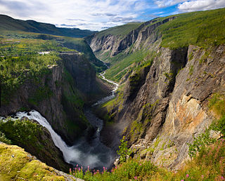
Eidfjord is a municipality in Hordaland county, Norway. The municipality is located in the traditional district of Hardanger. The administrative centre of the municipality is the village of Eidfjord, where the majority of the municipal population lives. The other major population centre in the municipality is the village of Øvre Eidfjord.

Flå Municipality in Buskerud, Norway

Flå is a municipality in Buskerud county, Norway. The administrative centre of the municipality is the village of Flå. The municipality of Flå was established when it was separated from the municipality of Nes on 1 January 1905. The municipality lies at the most southeasterly point in the valley and traditional region of Hallingdal.

Gol, Norway Municipality in Buskerud, Norway

Gol  is a municipality in Buskerud county, Norway. It is part of the traditional region of Hallingdal. The administrative center of the municipality is the village of Gol which is also the population center. Gol was established as a municipality on 1 January 1838. The area of Hemsedal was separated from Gol in 1897 to become a separate municipality. The municipality of Gol is bordered to the north by the municipality of Nord-Aurdal, to the east by Sør-Aurdal, to the south by Nes, and to the west by Ål and Hemsedal.

Hemsedal Municipality in Buskerud, Norway

Hemsedal is a municipality in Buskerud county, Norway. It is part of the traditional region of Hallingdal. The administrative centre of the municipality is the village of Trøym. Hemsedal lies on the Norwegian National Road 52. Hemsedal is located 220 km (136.70 mi) northwest of Oslo and 273 km (169.63 mi) from Bergen. In 1897, Hemsedal was separated from the municipality of Gol to become a municipality of its own.

Ål Municipality in Buskerud, Norway

Ål is a municipality in Buskerud county, Norway. It is part of the traditional region of Hallingdal. The administrative centre of the municipality is the village of Ål. The parish of Aal was established as a municipality on 1 January 1838. The area of Hol was separated from the municipality of Aal in 1877 to become a separate municipality.

Hol Municipality in Buskerud, Norway

Hol is a municipality in Buskerud county, Norway.

Hallingdal District in Buskerud, Norway

Hallingdal is a valley as well as a traditional district located in Buskerud county in Norway. It consists of six municipalities: Flå, Nes, Gol, Hemsedal, Ål and Hol.

Nesbyen

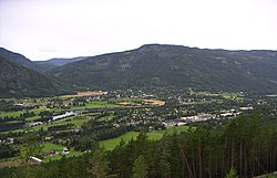
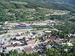
Nesbyen is a town in Nes municipality in the county of Buskerud, Norway. Nes is the administrative center of Nes municipality. Nes is located in the traditional district of Hallingdal.

Hallingdal Museum

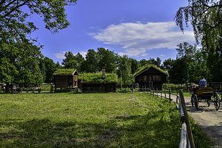
Hallingdal Museum Nesbyen is an open-air museum at Nesbyen within Nes in Buskerud, Norway.

Nes, Ådal hamlet in Ringerike, Buskerud, Norway

Nes i Ådal is a small village in the valley of Ådal in the municipality Ringerike in Buskerud, Norway.

References

  1. "Navn på steder og personer: Innbyggjarnamn" (in Norwegian). Språkrådet.
  2. "Forskrift om målvedtak i kommunar og fylkeskommunar" (in Norwegian). Lovdata.no.
  3. Norske Kommunevåpen (1990). "Nye kommunevåbener i Norden" . Retrieved 2009-01-10.
  4. "Immigrants and Norwegian-born to immigrant parents, by immigration category, country background and percentages of the population". ssb.no. Archived from the original on 2 July 2015. Retrieved 29 July 2017.
  5. Stagg, Frank Noel (1956). East Norway and its Frontier. George Allen & Unwin, Ltd.