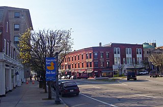
Bradford is a census-designated place (CDP) and historic district in the towns of Westerly and Hopkinton in Washington County, Rhode Island, United States. The population was 1,406 at the 2010 census. The Bradford Village Historic District was listed on the National Register of Historic Places in 1996 as a 224-acre (91 ha) area including 149 contributing buildings, one other contributing site, and one other contributing structure. The CDP as defined by the United States Census Bureau is located only in Westerly.

Charlestown is a town in Washington County, Rhode Island, United States. The population was 7,827 at the 2010 census.

Hopkinton is a town in Washington County, Rhode Island. The population was 8,188 at the 2010 census.

Westerly is a town on the southwestern shoreline of Washington County, Rhode Island, first settled by English colonists in 1661 and incorporated as a municipality in 1669. It is a beachfront community on the south shore of the state with a population of 22,787 as of the 2010 census.

The Pawcatuck River is a river in the US states of Rhode Island and Connecticut flowing approximately 34 miles (55 km). There are eight dams along the river's length. USS Pawcatuck was named after the river.
The Beaver River is a river in the U.S. state of Rhode Island. It flows approximately 11.0 miles (17.7 km). There are three dams along the river's length. The river is also famous locally for its trout fishing in the spring.
Chariho is a regional school district located in southern Rhode Island shared by three adjacent towns; Charlestown, Richmond, and Hopkinton. The name Chariho is a portmanteau derived by taking the first two letters from each town name and combining them together. The district operates four elementary schools, two of which are located in Hopkinton, in the villages of Ashaway and Hope Valley, one in Charlestown, and one in Richmond. The Chariho campus located in the Richmond village of Wood River Junction houses the Middle and High Schools, as well as the Chariho Career And Technical Center.

Alton is a small village of about 250 residents within the town of Richmond, Rhode Island. It is located about one hour south of Providence, the state's capital. The village is primarily residential, with no retail stores. Alton is located at a crossing of the Wood River and is 5 miles from the Pawcatuck River.
Sun Publishing Company is a daily and weekly newspaper publisher in southwest Rhode Island and southeast Connecticut, United States. It is a Westerly, Rhode Island-based subsidiary of RISN Operations.
The Wood River is a river in the U.S. states of Connecticut and Rhode Island. It flows approximately 25 miles (40 km) and is a major tributary of the Pawcatuck River. There are 8 dams along the river's length.
The Usquepaug River is a river in the U.S. state of Rhode Island. It flows approximately 12 km (7.5 mi) and is a major tributary of the Pawcatuck River. There are two dams along the river's length.

Carolina is a village that straddles the border of the towns of Charlestown and Richmond on the Pawcatuck River in Washington County, Rhode Island. Rhode Island Route 112 passes through the village. Carolina is identified as a census-designated place, with a population of 970 at the 2010 census.

Kenyon is a small village in the town of Richmond near its border with the town of Charlestown in the U.S. state of Rhode Island.

The Shannock Historic District is a historic mill village located along the Pawcatuck River in the towns of Richmond and Charlestown, Rhode Island. The postal code for Shannock is 02875. The village extends along Old Shannock Road, Railroad Street, and Shannock Village Road between two crossings of the Pawcatuck, which forms the border between the two towns. It lies mainly in Richmond, but extends along the road running southwest and southeast from the two crossings. Two mill complexes are the visual focal points of the village: the Carmichael plant on the west, and the Columbia Narrow Fabrics Company complex near the village center. The buildings in the village are predominantly residential worker housing set close to the road, which were built in the second half of the 19th century. There are two imposing Greek Revival houses, both built c. 1850, and one Late Victorian house, all of which belonged to mill owners. The area was listed on the National Register of Historic Places in 1983.
Matunuck is a village in South Kingstown, Rhode Island, United States near Charlestown, Rhode Island. The village is located on a point along the southern Atlantic coast of Rhode Island off U.S. Route 1. The village takes its name from a Native American word meaning "lookout" The Narragansett tribe made a summer encampment at this location before the land was sold to colonists as part of the Pettaquamscutt purchase.

Washington County, known locally as South County, is a county located in the U.S. state of Rhode Island. As of the 2010 census, the population was 126,979. Rhode Island counties have no governmental functions other than as court administrative and sheriff corrections boundaries, which are part of the state government.
Burdickville is a village located within the town of Hopkinton in the U.S. state of Rhode Island. The village is located in the southeastern part of town and is near the border with Charlestown at the Pawcatuck River.
South Hopkinton is a small village located in the town of Hopkinton, Rhode Island. Residents of South Hopkinton use the zip code for Bradford, Rhode Island, but the village of Bradford is located only within nearby Westerly.
Woodville is a small village in the towns of Richmond and Hopkinton in the U.S. state of Rhode Island.

Barberville is a small village located primarily in the town of Hopkinton, but also extending into Richmond in Washington County, Rhode Island, United States. Barberville is located to the north of Hopkinton's principal village, Hope Valley and uses Hope Valley's zip code, 02832.


