
Charlestown is a town in Washington County, Rhode Island, United States. The population was 7,997 at the 2020 census.

Hopkinton is a town in Washington County, Rhode Island. The population was 8,398 at the 2020 census.
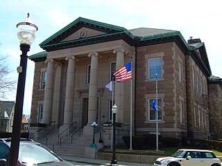
Westerly is a town on the southwestern shoreline of Washington County, Rhode Island, first settled by English colonists in 1661 and incorporated as a municipality in 1669. It is a beachfront community on the south shore of the state with a population of 23,359 as of the 2020 census.

The Pawcatuck River is a river in the US states of Rhode Island and Connecticut flowing approximately 34 miles (55 km). There are eight dams along the river's length. USS Pawcatuck was named after the river.

Wakefield is a village in the town of South Kingstown, Rhode Island, United States, and the commercial center of South Kingstown. Together with the village of Peace Dale, it is treated by the U.S. Census as a component of the census-designated place identified as Wakefield-Peacedale, Rhode Island. West Kingston, another South Kingstown village, was the traditional county seat of Washington County. Since 1991, the Washington County Courthouse has been in Wakefield. The Sheriff's Office which handles corrections is also in Wakefield.

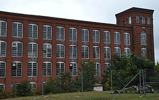
The Mechanic Street Historic District encompasses a historic 19th-century mill and mill village in a 14-block area of the Pawcatuck section of Stonington, Connecticut. Extending along the Pawcatuck River and south of West Broad Street, the area includes a large brick mill complex on the banks of the river, and a neighborhood of well-preserved worker housing on the road grid to its west. The district was listed on the National Register of Historic Places in 1988.
The Wood River is a river in the U.S. states of Connecticut and Rhode Island. It flows approximately 25 miles (40 km) and is a major tributary of the Pawcatuck River. There are 8 dams along the river's length.

Carolina is a village that straddles the border of the towns of Charlestown and Richmond on the Pawcatuck River in Washington County, Rhode Island. Rhode Island Route 112 passes through the village. Carolina is identified as a census-designated place, with a population of 970 at the 2010 census.

Saylesville is a village and historic district in Lincoln, Rhode Island.
Lafayette Village is a historic district extending along Ten Rod Road in North Kingstown, Rhode Island. It encompasses a linear rural and industrial village, running from the Wickford Junction railroad crossing in the west to Angel Avenue in the east, and includes a number of residential properties on adjacent side streets. The centerpiece of the district is the Rodman Manufacturing Company complex, which operated here for a century beginning in the 1840s. The Robert Rodman Mansion, a Second Empire house with an elaborate porch, stands at 731 Ten Rod Road, and the Walter Rodman House, built in the 1870s, is even more elaborately decorated. Most of the residential stock in the district is mill-related housing built by the Rodmans for their workers.

The Shady Lea Historic District is a historic district on Shady Lea and Tower Hill Roads in North Kingstown, Rhode Island. It encompasses a predominantly residential linear district extending along Shady Lea Road southward from Tower Hill Road. Most of the houses along Shady Lea Road are mill worker housing built in the 19th century for workers at the mill complex which stands at the edge of the Shady Lea Mill Pond, at the southern end of the district. This area is a well-preserved example of the numerous rural mill complexes which dotted the Rhode Island countryside in the 19th century.

Wyoming is a village and census-designated place on the Wood River in southern Rhode Island, primarily in the town of Richmond, Rhode Island, but extending north across the river into the town of Hopkinton, Rhode Island. The population was 270 at the 2010 census. It is the site of the Wyoming Village Historic District and a post office assigned ZIP code 02898.

The South Britain Historic District encompasses the core of the unincorporated village of South Britain in Southbury, Connecticut, United States. The village arose in the 18th century as an industrial center serving the surrounding agricultural community, powered by the Pomperaug River, and rivalled the town center of Southbury in importance. It was listed on the National Register of Historic Places in 1987.
The Albert S. Potter Octagon House is an historic octagonal house located at 4 Carolina Main Street on the corner of Shannock Hill Road in the village of Carolina in Richmond, Rhode Island. It was built by watchmaker Albert S. Potter in 1857. Potter reportedly did his watchmaking in the octagonal cupola atop the two-story house. The building is now covered with asbestos siding and is owned by the Carolina Preservation and Band Society.

Anthony is a village along Route 117 within the town of Coventry, Rhode Island near the villages of Washington and Quidnick on the southwestern banks of the Pawtuxet River. The village comprises "Anthony, Arnold, Boston, Mapledale, Meeting, Taft, Washington and Laurel Avenue."

The Phillipsdale Historic District encompasses a historic mill village along the Seekonk River in East Providence, Rhode Island. The village grew up around the Richmond Paper Company Mill Complex, built 1883-1887, which is separately listed on the National Register. It also includes 75 units of worker housing, as well as five houses that predate the mill complex's construction. The Phillipsdale area was the largest source of employment in East Providence between 1893 and 1910. The district is centered on Roger Williams Avenue and Bourne Avenue, and includes properties on Ruth Avenue and the grid of roads between Ruth and Roger Williams. It also includes Omega Pond and the Omega Pond Railroad Bridge.

Barberville is a small village located primarily in the town of Hopkinton, but also extending into Richmond in Washington County, Rhode Island, United States. Barberville is located to the north of Hopkinton's principal village, Hope Valley and uses Hope Valley's zip code, 02832.

Blackstone River Valley National Historical Park is a National Park Service unit in the states of Rhode Island and Massachusetts. The park was created for the purpose of preserving, protecting, and interpreting the industrial heritage of the Blackstone River Valley and the urban, rural, and agricultural landscape of that region. The Blackstone River Valley was the site of some of the earliest successful textile mills in the United States, and these mills contributed significantly to the earliest American Industrial Revolution. The subsequent construction of the Blackstone Canal, a few years after the successful completion of the Erie Canal, helped to sustain the region's industrial strength.

The Perry Homestead Historic District encompasses a cluster of residences built as a family compound by the locally prominent Perry family in Westerly, Rhode Island. Extending mainly along the northern part of Margin Street south of downtown Westerly, the area was developed in the 1920s, and includes five family residences, a caretaker's house, and shared landscaping of a former gentleman's farm. The district was added to the National Register of Historic Places in 2016.
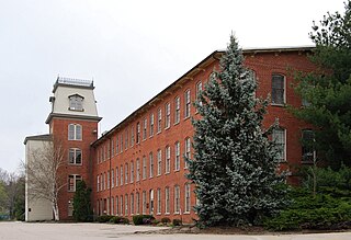
The William Clark Company Thread Mill is a historic textile mill complex at Pawcatuck Avenue and River Road in the Pawcatuck village of Stonington, Connecticut. Developed beginning in 1892, it is a well-preserved example of a late 19th-century mill, which was a major economic force in the region. The mill was listed on the National Register of Historic Places in 2008.


