Related Research Articles

Kent is a ceremonial county in South East England. It is bordered by Essex across the Thames Estuary to the north, the Strait of Dover to the south-east, East Sussex to the south-west, Surrey to the west, and Greater London to the north-west. The county town is Maidstone.

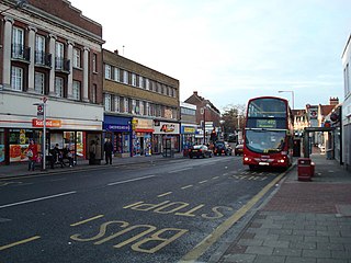
Bexleyheath is a town in south-east London, England, in the London Borough of Bexley. It had a population of approximately 15,600 in 2021 and is 12 miles southeast of Charing Cross. It is identified in the London Plan as one of 35 major centres in London. Its post town takes in other surrounding neighbourhoods, including Barnehurst, West Heath and Upton.

Erith is an area in south-east London, England, 13.3 miles (21.4 km) east of Charing Cross. Before the creation of Greater London in 1965, it was in the historical county of Kent. Since 1965 it has formed part of the London Borough of Bexley. It lies north-east of Bexleyheath and north-west of Dartford, on the south bank of the River Thames.
Sidcup is an area of south-east London, England, primarily in the London Borough of Bexley. It is 11.3 miles (18.2 km) south-east of Charing Cross, bordering the London Boroughs of Bromley and Greenwich. It was part of Kent prior to the creation of Greater London in 1965.
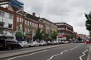
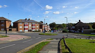
Welling is a town in South East London, England, in the London Borough of Bexley, 1.5 miles (2.4 km) west of Bexleyheath, 4 miles (6.4 km) southeast of Woolwich and 10.5 miles (16.9 km) of Charing Cross. It was part of Kent prior to the creation of Greater London in 1965.

The London Borough of Bexley is a London borough in south-east London, forming part of Outer London. It has a population of 248,287. The main settlements are Sidcup, Erith, Bexleyheath, Crayford, Welling and Old Bexley. The London Borough of Bexley is within the Thames Gateway, an area designated as a national priority for urban regeneration. The local authority is Bexley London Borough Council.
Bromley is a large town in Greater London, England, within the London Borough of Bromley. It is 9+1⁄2 miles southeast of Charing Cross, and had an estimated population of 88,000 as of 2023.
Archant Limited is a newspaper and magazine publishing company with headquarters in Norwich, England. The group publishes four daily newspapers, around 50 weekly newspapers, and 80 consumer and contract magazines. The company is a subsidiary of Newsquest, which is owned by American newspaper publishing company Gannett.
Belvedere is a town in south east London, England, within the London Borough of Bexley. It lies close to the River Thames, with Erith to the east, Bexleyheath to the south, and Abbey Wood and Thamesmead to the west. Before the creation of Greater London in 1965, Belvedere was in the administrative county of Kent.

Foots Cray is an area of South East London, England, within the London Borough of Bexley. Prior to 1965 it was in the historic county of Kent. It is located south-east of Sidcup, north of Orpington and north west of Swanley.

Dartford is the principal town in the Borough of Dartford, Kent, England. It is located 18 mi (29 km) south-east of Central London and is situated adjacent to the London Borough of Bexley to its west. To its north, across the Thames estuary, is Thurrock in Essex, which can be reached via the Dartford Crossing. To its east lies the Borough of Gravesham and to the south the district of Sevenoaks. It had a population of 51,240.

The Bexleyheath line runs for 8 miles (13 km) from Lewisham to Dartford in Kent. It separates from the North Kent Line just to the east of Blackheath Station, and rejoins the same line just south of Slade Green near Dartford.
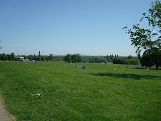
Danson Park is a public park in the London Borough of Bexley, South East London, located between Welling and Bexleyheath. At 75 hectares, it is the second largest public park in the borough, and the most used by the community. Opened in 1925, it is often considered the finest green open space in the borough, and is Grade II listed on the Register of Historic Parks and Gardens. The park also gives its name to the electoral ward that covers the park and the surrounding area. The park is located at grid reference TQ472752. The southern boundary of both the park and the ward is delineated by Rochester Way, the A2 road.
Albany Park is an area in south east London, England, within the London Borough of Bexley. It is located 12.0 miles (19 km) south east of Charing Cross. Located midway between Sidcup and Bexley, Albany Park is situated on high ground overlooking the valleys of the River Cray and the River Shuttle.

Slade Green is an area of South East London, England, within the London Borough of Bexley. It lies northeast of Bexleyheath, northwest of Dartford and south of Erith, and 14 miles (23 km) east-southeast of Charing Cross.
Ruxley is a rural settlement of South East London, England that straddles the boundary of the London Boroughs of Bromley and Bexley. It is located 13 miles southeast of Charing Cross, the traditional centre of London, in the Metropolitan Green Belt between Sidcup and Swanley and is also adjacent to the Greater London border with the county of Kent.
Northcliffe Media was a large regional newspaper publisher in the UK and Central and Eastern Europe. In 2012 the company was sold by Daily Mail and General Trust (DMGT) to a newly formed company, Local World, which also bought Iliffe News and Media from the Yattendon Group. In October 2015, Trinity Mirror, later Reach plc, bought Local World.
The Kent Rugby Football Union is the governing body for the sport of rugby union in the county of Kent in England. The union is the constituent body of the Rugby Football Union (RFU) for Kent, and administers and organises rugby union clubs and competitions in the county. It also administers the Kent county rugby representative teams.
References
- ↑ "Search Results". ABC. Audit Bureau of Circulations. Archived from the original on 15 December 2014.
- ↑ "Our History | Contact Us | Homepage – News Shopper". www.newsshopper.co.uk. Archived from the original on 10 February 2009.