
Tung Lung Chau, previously known as Nam Tong Island (南堂島) or Nam Fat Tong (南佛堂) is an island located off the tip of the Clear Water Bay Peninsula in the New Territories of Hong Kong. It is also referred by Hong Kong people as Tung Lung To or Tung Lung Island (東龍島). The island is largely uninhabited. Administratively, it belongs to Sai Kung District.
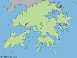
Double Island or Wong Wan Chau is an island located in the north-eastern part of Hong Kong. Administratively, it is part of North District.
Tung Ping Chau is an island in Hong Kong. It was known as Ping Chau. Tung is prepended to the name so as to avoid possible confusion with Peng Chau, another island in Hong Kong with an identically pronounced name in the Cantonese language. Administratively, the island is part of the Tai Po District in the New Territories.

Tolo Harbour, or Tai Po Hoi is a sheltered harbour in northeast New Territories of Hong Kong.

Nga Ying Chau, or Cap Island, was an island off the northeast shore of Tsing Yi Island of Hong Kong, separated by a small harbour, Mun Tsai Tong, with Tsuen Wan at its northeast, just across the Rambler Channel. When the small harbour was reclaimed for the development of a new town, the island became part of Tsing Yi Island. The island was once home to the CRC Oil Storage Depot, which later relocated to the other side of Tsing Yi Island owing to its proximity to the residential area. The former island is now a small hill on the northeast point of Tsing Yi Island, and Villa Esplanada, a private housing estate, stands on the hills.
Plover Cove or Shuen Wan Hoi is a cove in the Tai Po District of Hong Kong, near Tolo Channel and Tolo Harbour.

Plover Cove Country Park is a country park in Hong Kong located in the Northeastern New Territories. The original country park was established on 7 April 1978, covering 4,594 hectares of natural terrain in the administrative North District and Tai Po District. A northern extension to the park, Plover Cove (Extension) Country Park, was designated on 1 June 1979, covering the Double Haven islets and Ping Chau.

Three Fathoms Cove or Kei Ling Ha Hoi is a cove in Tai Po District, Hong Kong. It is surrounded by Shap Sze Heung, Kei Ling Ha, Yung Shue O (榕樹澳), Wong Tei Tung and Sham Chung. Most of its east shore constitutes part of the Sai Kung West Country Park.
Tolo Channel or Chek Mun Hoi Hap is a channel south of Plover Cove in Hong Kong connecting Tolo Harbour to Mirs Bay. At Mirs Bay end, it is named North Channel.

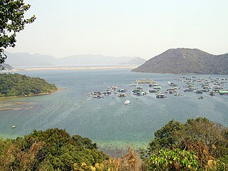
Double Haven or Yan Chau Tong is a harbour enclosed by Double Island, Crescent Island and Crooked Island with north-eastern New Territories, Hong Kong. Parts of the haven fall within Yan Chau Tong Marine Park to protect the wildlife of the marine creatures. It is known for its scenery and natural environment, and for the calm seas from which its English name derives. Double Haven contains many deep red coloured rocks because of iron oxide.

Inner Port Shelter or Sai Kung Hoi is a harbour off the shore of Sai Kung Town, south of Sai Kung Peninsula, Hong Kong. Sharp Island is the major island in the harbour.
Sai Kung East Country Park is a 44.77 square kilometres (17.29 sq mi) country park on the Sai Kung Peninsula in Hong Kong. It opened in 1978 and has features including:
Kiu Tsui Country Park is a 1 square kilometre (0.39 sq mi) country park in Sai Kung, Hong Kong. The park opened in 1979 and includes features such as:

Wong Chuk Kok Tsui, formerly known as Bluff Head, is a cape in north east New Territories, Hong Kong. Administratively, it is part of North District and Tai Po District.

Ma Shi Chau Special Area is a Special Area of Hong Kong. It is located in Tai Po District and in Tolo Harbour, in the northeast of the New Territories.

Yim Tin Tsai is an island of Hong Kong located in Tolo Harbour.

Yeung Chau is an uninhabited island of Hong Kong located in Plover Cove, Tolo Harbour, in the northwestern part of the territory. Administratively, it is part of Tai Po District.

Wu Kau Tang is an area in Northeast New Territories, Hong Kong. It is administratively part of North District and is enclosed by Plover Cove Country Park on all sides. It is the starting point of the Wu Kau Tang Country Trail and the Plover Cove Reservoir Country Trail.

Pak Sha Chau is an island of Hong Kong. Administratively, it is part of the Sai Kung District and Kiu Tsui Country Park located to the northwest of Kiu Tsui Chau.


