Grass Island, Hong Kong

Last updated
Grass Island
塔門
Above Grass Island Hong Kong.jpg

Grassisland.png

Map showing the location of Grass Island within Hong Kong
Geography
Location Tai Po District
Coordinates 22°28′35″N114°21′45″E / 22.47639°N 114.36250°E / 22.47639; 114.36250 Coordinates: 22°28′35″N114°21′45″E / 22.47639°N 114.36250°E / 22.47639; 114.36250
Area 1.69 km2 (0.65 sq mi)
Administration
Demographics
Population 100 (approx)
Grass Island, Hong Kong
Traditional Chinese 塔門
View from a Grass Island hilltop, a campsite can be seen atop the distant hill View from a hilltop in Tap Mun.jpg
View from a Grass Island hilltop, a campsite can be seen atop the distant hill
Dirt path on the edge of a Grass Island cliff Dirt paths encircling Tap Mun's hilltops.jpg
Dirt path on the edge of a Grass Island cliff

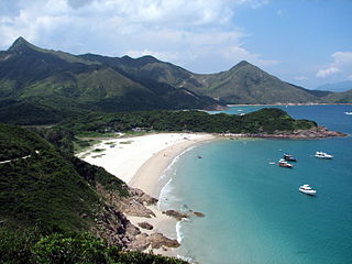
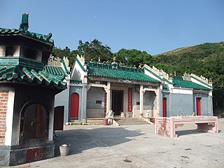
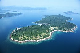
Grass Island (Chinese :塔門) or Tap Mun is an island in Hong Kong, located in the northeastern part of the territory. Its area is 1.69 km². [1] Administratively, it is part of the Tai Po District. There are about 100 people living on the island, and feral cattles are known on the island. [2]

Traditional Chinese characters Traditional Chinese characters

Traditional Chinese characters are Chinese characters in any character set that does not contain newly created characters or character substitutions performed after 1946. They are most commonly the characters in the standardized character sets of Taiwan, of Hong Kong and Macau, and in the Kangxi Dictionary. The modern shapes of traditional Chinese characters first appeared with the emergence of the clerical script during the Han Dynasty, and have been more or less stable since the 5th century.

Island Any piece of sub-continental land that is surrounded by water

An island or isle is any piece of sub-continental land that is surrounded by water. Very small islands such as emergent land features on atolls can be called islets, skerries, cays or keys. An island in a river or a lake island may be called an eyot or ait, and a small island off the coast may be called a holm. A grouping of geographically or geologically related islands is called an archipelago, such as the Philippines.

Hong Kong East Asian city

Hong Kong, officially the Hong Kong Special Administrative Region of the People's Republic of China and commonly abbreviated as HK, is a special administrative region on the eastern side of the Pearl River estuary in southern China. With over 7.4 million people of various nationalities in a 1,104-square-kilometre (426 sq mi) territory, Hong Kong is the world's fourth most densely populated region.

Contents

Location

Grass Island is located in the northeastern part of the Hong Kong territory, between Mirs Bay and the North Channel. It lies north of the Sai Kung East Country Park on the Sai Kung Peninsula. To the east is Kung Chau, to the south is the South Channel, to the west is Wan Tsai and to the southwest is Long Harbour.

Mirs Bay bay

Mirs Bay is a bay in the northeast of Kat O and Sai Kung Peninsula of Hong Kong, China. The north and east shores are surrounded by Yantian and Dapeng New District of Shenzhen. Ping Chau stands in the midst of the bay.

Sai Kung East Country Park

Sai Kung East Country Park is a 44.77 square kilometres (17.29 sq mi) country park on the Sai Kung Peninsula in Hong Kong. It opened in 1978 and has features including:

Sai Kung Peninsula

Sai Kung Peninsula is a peninsula in the easternmost part of the New Territories in Hong Kong. Its name comes from Sai Kung Town in the central southern area of the peninsula. The southern part of the peninsula is administrated by Sai Kung District, the north by Tai Po District and the northwest by Sha Tin District.

History

A tablet in the Tin Hau Temple on the island states Tap Mun, as part of Mirs Bay, was registered under the administration of the Dongguan County by the Tsui and Yip clans before 1573 and that they thus held the subsoil (地骨; dei6gwat1; "the bones of the land") rights as taxpayer under the Customary Land Law. By the late 17th century, Tanka fisherman began to use the anchorage and built the temple, the topsoil (地皮; dei6pei4; "the skin of the land") rights being granted to them in perpetuity by the subsoil title holders. As a result of a dispute over the land that arose in the mid-18th century, the Magistrate and Prefect of the Dongguan County Court ruled that the Customary Land Law took precedence over the Imperial Law, thus preserving the subsoil:topsoil rights status quo (including the rule that, though the tax-paid land area of the subsoil holder was only the temple itself and its immediately vicinity, the rights of the topsoil holders extended automatically to all adjoining waste and mountainous land, i.e. the entire island). [3] Over time, the first topsoil holder's interest in the land will have passed to an ancestral trust of his family so that by the time of British colonial rule, the effective title holders in the topsoil will have been a trust of the villagers as a whole. The British refused to recognise all subsoil rights (their taxpaying status to the Imperial government being at odds with British sovereignty and its Crown land concept), leaving the only effective right in the land in the hands of the tenant topsoil rights holders, i.e. the village ancestral trust of the Tanka families. [4]

Tanka is a genre of classical Japanese poetry and one of the major genres of Japanese literature.

Tap Mun New Fishermen's Village, erected 1964, as seen looking east from Tit Shue Pai Tap Mun New Fishermen's Villiage in 2016.jpg
Tap Mun New Fishermen's Village, erected 1964, as seen looking east from Tit Shue Pai

By the 1960s, the Tankas were living in wretched conditions on the island and, in response to their need, a charity from New Zealand funded the erection of a New Village to house them. The structures, considered an eyesore but functional, were completed in 1964 and continued in use as of 2016.[ citation needed ]

Demographics

At its peak, Grass Island had 2,000 residents. However, many moved to the city centre to live. Now many residents run stores or restaurants for local tourists visiting the island. The villagers are mostly farmers, merchants or fishermen. The latter category has recently diminished as many youths from fishing families have chosen to work in the city instead. Due to the population outflow, the last school on the island closed down in 2003. [5]

Climate

Climate data for Tap Mun (1994–2016)
MonthJanFebMarAprMayJunJulAugSepOctNovDecYear
Record high °C (°F) 28.6
(83.5)
28.7
(83.7)
30.0
(86)
32.8
(91)
34.9
(94.8)
37.2
(99)
37.4
(99.3)
37.1
(98.8)
36.1
(97)
34.3
(93.7)
31.4
(88.5)
28.6
(83.5)
37.4
(99.3)
Average high °C (°F) 18.5
(65.3)
18.8
(65.8)
21.0
(69.8)
24.7
(76.5)
28.4
(83.1)
30.7
(87.3)
31.9
(89.4)
31.6
(88.9)
30.7
(87.3)
28.6
(83.5)
24.8
(76.6)
20.6
(69.1)
25.9
(78.6)
Daily mean °C (°F) 14.7
(58.5)
15.5
(59.9)
17.8
(64)
21.7
(71.1)
25.2
(77.4)
27.4
(81.3)
28.2
(82.8)
27.9
(82.2)
27.2
(81)
25.0
(77)
21.0
(69.8)
16.6
(61.9)
22.3
(72.1)
Average low °C (°F) 11.6
(52.9)
12.9
(55.2)
15.3
(59.5)
19.4
(66.9)
22.8
(73)
24.9
(76.8)
25.3
(77.5)
25.2
(77.4)
24.6
(76.3)
22.4
(72.3)
18.2
(64.8)
13.5
(56.3)
19.7
(67.5)
Record low °C (°F) 2.1
(35.8)
3.5
(38.3)
5.6
(42.1)
9.1
(48.4)
15.1
(59.2)
19.6
(67.3)
21.6
(70.9)
22.4
(72.3)
18.1
(64.6)
14.8
(58.6)
7.9
(46.2)
3.6
(38.5)
2.1
(35.8)
Average precipitation mm (inches) 36.3
(1.429)
39.0
(1.535)
69.7
(2.744)
157.7
(6.209)
288.2
(11.346)
370.3
(14.579)
313.2
(12.331)
307.2
(12.094)
193.9
(7.634)
56.9
(2.24)
39.3
(1.547)
25.5
(1.004)
1,897.2
(74.693)
Average relative humidity (%) 77 80 83 86 87 88 86 87 83 79 77 73 82
Source: Hong Kong Observatory [6]

Attractions

Camping

The hilltop of Grass Island is a popular camping site, renowned for the contrast in temperature and wind conditions between day and night. Temperatures drop and winds soar during the nighttime but die down as the day approaches, when the dawn marks the beginning of a temperature rise. It is also well known for providing panoramic views of the surrounding seas, and so provides a brief escape away from busy city life. The very gentle slopes of the hilltops are a favourite amongst campers, although there is the danger of the bordering cliffs.

Camping outdoor recreational activity

Camping is an outdoor activity involving overnight stays away from home in a shelter, such as a tent. Typically participants leave developed areas to spend time outdoors in more natural ones in pursuit of activities providing them enjoyment. To be regarded as "camping" a minimum of one night is spent outdoors, distinguishing it from day-tripping, picnicking, and other similarly short-term recreational activities. Camping can be enjoyed through all four seasons.

Temples

Tin Hau Temple on Grass Island Tap Mun Tin Hau Temple 1.jpg
Tin Hau Temple on Grass Island

The temple complex at Grass Island comprises three temples in two buildings: the first building is a Tin Hau Temple, built in 1737, to which an annex was later added, housing a Kwan Tai Temple. [7] To its south, Shui Yuet Kung (水月宮; "water moon temple"), built in 1788, is dedicated to Kwun Yam (Guan Yin) and the Earth God. [8] The Tin Hau Temple is a Grade II historic building, while Shui Yuet Kung is listed as Grade III. [9]

On festival days, such as Kwun Yam's birthday, on the 19th day of the second lunar month, [8] many fishermen arrive at Grass Island to pray for peace and calm. The Tin Hau Festival (天后誕) is celebrated annually on the 23rd day of the third lunar month. [7] In addition, a marine parade is held once every ten years to celebrate the Tin Hau Festival. [10] The temple at Grass Island is one of the two Tin Hau Temples in Hong Kong that have such a marine parade: the other one is the Tin Hau Temple on Leung Shuen Wan (High Island). [11]

Dining

There is one seafood restaurant and a number of small tea restaurants on the Grass Island, many of which are known for 'ice-less' ice-cold milk tea and boiled squid dishes. Some fishermen of Grass Island make a living by selling their sun-dried catch. Sun-dried fish and shrimp are popular amongst local tourists.

Other attractions

Tsui Wah Ferry at Grass Island. Tsui Wah Ferry Service in Tap Mun.jpg
Tsui Wah Ferry at Grass Island.

Transportation

Grass Island is served by Tsui Wah Ferry Service. The ferry/kai-to services are available from:

  1. Wong Shek Pier in Sai Kung; about once every two hours, with higher frequency on weekends and holidays.
  2. Ma Liu Shui Pier near Chinese University in Tai Po; twice daily, with an extra departure on weekends and holidays. [12]

Related Research Articles

Sai Kung District District in New Territories, Hong Kong

Sai Kung District is the fifth largest district in Hong Kong in terms of area. It comprises the southern half of Sai Kung Peninsula and Clear Water Bay Peninsula in the New Territories plus a strip to the east of Kowloon. It is made up of the Sai Kung Town, Sai Kung rural areas, Tseung Kwan O New Town and over 70 islands of different sizes. The administrative centre is Sai Kung Town but the district's population is concentrated in Tseung Kwan O. The district has the second youngest residents. Known as the "back garden of Hong Kong", Sai Kung has been able to retain its natural scenery, and where the Hong Kong Global Geopark is located. Behind the modern buildings, a lot of traditional customs and cultures are still retained in the rural villages.

Places of worship in Hong Kong

Hong Kong counts approximately 600 temples, shrines and monasteries. While Buddhism and Christianity are the most widely practiced religions, most religions are represented in the Special Administrative Region.

Declared monuments of Hong Kong are places, structures or buildings legally declared to receive the highest level of protection. In Hong Kong, declaring a monument requires consulting the Antiquities Advisory Board, the approval of the chief executive as well as the publication of the notice in government gazette.

Tai Wai human settlement

Tai Wai is an area in the New Territories of Hong Kong, located between Sha Tin New Town and the Lion Rock. It is the largest part of the Sha Tin District.

Long Harbour (Hong Kong)

Long Harbour, also known as Tai Tan Hoi, is a natural harbour formed from an inlet of Mirs Bay to the north of Sai Kung Peninsula, Hong Kong.

Lunar New Year Fair

Lunar New Year Fair is a type of fair held annually a few days before Lunar New Year in Chinese New Year markets in China. Flower fairs are primarily practiced by the Cantonese, and spread with Cantonese immigration.

High Island, Hong Kong former island of Hong Kong

High Island or Leung Shuen Wan is a former island in the southeast of Sai Kung Peninsula, Hong Kong. The island was connected to the peninsula by two dams that enclosed the Kwun Mun Channel (官門海峽), thereby forming the High Island Reservoir. The dams were constructed between 1969 and 1979. The area is part of the Sai Kung East Country Park. It is now a designated fish culture zone and features several seafood restaurants along the shore.

Joss House Bay

Joss House Bay, also known as Tai Miu Wan indigenously, is near the south end of Clear Water Bay Peninsula in Hong Kong. The Cantonese name Tai Miu Wan means "the bay of large temple" after the oldest Tin Hau Temple in Hong Kong.

Wong Shek Pier

Wong Shek Pier is a public pier on the shore of Long Harbour (赤徑海) in the north-east of Hong Kong's New Territories. It is situated in the Wong Shek (黃石) area of the Sai Kung Peninsula, and is in Tai Po District.

Tin Hau temples in Hong Kong Wikimedia list article

The following is an incomplete list of the over 100 Tin Hau Temples dedicated to Tin Hau (Mazu) in Hong Kong. They include:

Yim Tin Tsai (Tai Po) island in Peoples Republic of China

Yim Tin Tsai is an island of Hong Kong located in Tolo Harbour.

The Chinese Temples Committee is a statutory body in Hong Kong established under the Chinese Temples Ordinance (華人廟宇條例). It is mainly responsible for the operation and management of twenty-four temples directly under its management. It also handles temple registration. There are 19 additional temples, of which management has been delegated to other organisations.

Tin Hau Temple, Joss House Bay building in Hong Kong, China

The Tin Hau Temple in Joss House Bay, sometimes referred to as Tai Miu is Hong Kong's oldest and largest Tin Hau Temple. It is also said to be the most popular Tin Hau temple both for fishermen and for others in Hong Kong.

Ko Lau Wan

Ko Lau Wan is a remote village of Sai Kung Peninsula, Hong Kong, within the Sai Kung East Country Park. Administratively, it is under the jurisdiction of Tai Po District.

References

  1. Survey and Mapping Office, Lands Department: Hong Kong geographic data sheet
  2. 陳漢榮. 陳盛臣. 2003. 短線遊:跟住牛屎遊塔門. Retrieved on May 08, 2017
  3. Faure, David; Luk, Bernard; Ng, Alice (1986). The Historical Inscriptions of Hong Kong. Urban Council of Hong Kong. pp. 27–28.
  4. Hase, Patrick (1 April 2013). Custom, Land and Livelihood in Rural South China: The Traditional Land Law of Hong Kong's New Territories, 1750-1950. Hong Kong University Press. p. 40. ISBN   9789888139088.
  5. 1 2 Antiquities and Monuments Office. Brief Information on Proposed Grade III Items. Item #982. King Lam School, Tap Mun, Tai Po Archived 2013-09-22 at the Wayback Machine .
  6. "Monthly Means of Meteorological Elements for Tap Mun, 1994-2016". Hong Kong Observatory. Retrieved February 8, 2017.
  7. 1 2 Antiquities and Monuments Office. Brief Information on Proposed Grade III Items. Item #707. Tin Hau Temple, Ha Wai, Tap Mun, Tai Po Archived 2013-09-22 at the Wayback Machine .
  8. 1 2 Antiquities and Monuments Office. Brief Information on Proposed Grade III Items. Item #1035. Shui Yuet Kung, Ha Wai, Tap Mun, Tai Po Archived 2013-09-22 at the Wayback Machine .
  9. 1 2 Antiquities and Monuments Office: List of the Historic Buildings in Building Assessment Archived 2011-12-15 at the Wayback Machine .
  10. Antiquities and Monuments Office. Brief Information on Proposed Grade III Items. Item #617. Tin Hau Temple, Leung Shuen Wan, Sai Kung Archived 2013-09-22 at the Wayback Machine .
  11. Chan, Tin-kuen, Anthony, "Parade for the queen: safeguarding the intangible heritage of the Tin Hau Sea Ritual in Leung Shuen Wan, Sai Kung" Archived 2011-10-05 at the Wayback Machine ., University of Hong Kong dissertation, 2006
  12. Hong Kong Place - Tap Mun