North York, Wisconsin

Last updated

North York, Wisconsin
North York Wisconsin Downtown.jpg
Downtown North York
USA Wisconsin location map.svg
Red pog.svg
North York
Usa edcp location map.svg
Red pog.svg
North York
Coordinates: 46°23′34″N90°46′40″W / 46.39278°N 90.77778°W / 46.39278; -90.77778
Country Flag of the United States.svg  United States
State Flag of Wisconsin.svg  Wisconsin
County Ashland
Town Ashland
Elevation
271 m (889 ft)
Time zone UTC-6 (Central (CST))
  Summer (DST) UTC-5 (CDT)
Area code(s) 715 & 534
GNIS feature ID1570521 [1]

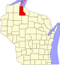
North York is an unincorporated community located in the town of Ashland, Ashland County, Wisconsin, United States. [1] It is located on Wisconsin Highway 13.

Sign for North York on WIS13 North York Wisconsin Sign WIS13.jpg
Sign for North York on WIS13

Notes

  1. 1 2 "North York, Wisconsin". Geographic Names Information System . United States Geological Survey, United States Department of the Interior.


Related Research Articles

<span class="mw-page-title-main">Bayfield County, Wisconsin</span> County in Wisconsin, United States

Bayfield County is a county located in the U.S. state of Wisconsin. As of the 2020 census, its population is 16,220. Its county seat is Washburn. The county was created in 1845 and organized in 1850. The Red Cliff Band of Lake Superior Chippewa has a reservation in Bayfield County and is the county's largest employer.

<span class="mw-page-title-main">Ashland County, Wisconsin</span> County in Wisconsin, United States

Ashland County is a county located in the U.S. state of Wisconsin. As of the 2020 census, the population was 16,027. Its county seat is Ashland. The county was formed on March 27, 1860, from La Pointe County. The county partly overlaps with the reservation of the Bad River Band of the Lake Superior Tribe of Chippewa Indians.

<span class="mw-page-title-main">Gingles, Wisconsin</span> Town in Wisconsin, United States

Gingles is a town in Ashland County in the U.S. state of Wisconsin. The population was 778 at the 2010 census. The unincorporated community of White River is located in the town.

<span class="mw-page-title-main">Sanborn, Wisconsin</span> Town in Wisconsin, United States

Sanborn is a town in Ashland County in the U.S. state of Wisconsin. The population was 1,331 at the 2010 census. The unincorporated communities of Bayfront, Birch, Birch Hill, Diaperville, Franks Field, New Odanah, Odanah, and Sedgwick are located in the town. Long Island, one of the Apostle Islands, is also a part of the town. The entire town is part of the Bad River Reservation of the Bad River Band of the Lake Superior Tribe of Chippewa Indians.

<span class="mw-page-title-main">Eileen, Wisconsin</span> Town in Wisconsin, United States

Eileen is a town in Bayfield County, Wisconsin, United States. The population was 681 at the 2010 census. The unincorporated community of Ashland Junction is located in the town.

Ashland is a town in Ashland County, Wisconsin. The population was 594 at the time of the 2010 census. The city of Ashland, population 7,908, is located about 15 miles (24 km) northwest of the town. The unincorporated communities of High Bridge, Minersville, North York, and part of Jolmaville are located in the town.

<span class="mw-page-title-main">Ashland, Wisconsin</span> City in Wisconsin, United States

Ashland is a city in Ashland and Bayfield counties in the U.S. state of Wisconsin. It is the county seat of Ashland County. The city is a port on Lake Superior, near the head of Chequamegon Bay. The population was 7,908 at the 2020 census, all of whom resided in the Ashland County portion of the city. The unpopulated Bayfield County portion is in the city's southwest, bordered by the easternmost part of the Town of Eileen.

<span class="mw-page-title-main">Apostle Islands</span> Lake Superior archipelago in northern Wisconsin

The Apostle Islands are a group of 22 islands in Lake Superior, off the Bayfield Peninsula in northern Wisconsin. The majority of the islands are located in Ashland County—only Sand, York, Eagle, and Raspberry Islands are located in Bayfield County. All the islands except for Madeline Island are part of the Apostle Islands National Lakeshore. The islands in Ashland County are all in the Town of La Pointe, except for Long Island, which is in the Town of Sanborn, while those in Bayfield County are in the Towns of Russell and Bayfield.

<span class="mw-page-title-main">Ashland Harbor Breakwater Light</span> Lighthouse

The Ashland Harbor Breakwater lighthouse, also known as Ashland Breakwater Lighthouse, is an operational lighthouse located near Ashland in Ashland County, Wisconsin, USA. Located in Chequamegon Bay of Lake Superior, it is owned and managed by the National Park Service, and is a part of the Apostle Islands National Lakeshore. It sits at the end of a long and detached breakwater, which creates an artificial harbor.

<span class="mw-page-title-main">Chequamegon Bay</span> Inlet of Lake Superior in Wisconsin, USA

Chequamegon Bay is an inlet of Lake Superior in Ashland and Bayfield counties in the extreme northern part of Wisconsin.

<span class="mw-page-title-main">Congress Township, Wayne County, Ohio</span> Township in Ohio, United States

Congress Township is one of the sixteen townships of Wayne County, Ohio, United States. The 2000 census found 4,435 people in the township, 2,681 of whom lived in the unincorporated portions of the township.

Salmo is an unincorporated community in Bayfield County, Wisconsin, United States.

Sand Bay is an unincorporated community in the town of Russell, Bayfield County, Wisconsin, United States. The community is located within the Red Cliff Indian Reservation.

Van Buskirk is an unincorporated community located in the town of Oma, Iron County, Wisconsin, United States.

Birch is an unincorporated community located in the town of Sanborn, Ashland County, Wisconsin, United States. Birch is located along U.S. Route 2 on the Bad River Indian Reservation, 15.15 miles (24.38 km) east-southeast of Ashland.

Ashland Junction is an unincorporated community located in the town of Eileen, Bayfield County, Wisconsin, United States.

<span class="mw-page-title-main">Huntersfield Mountain</span> Mountain in New York, United States

Huntersfield Mountain is a mountain located in the Catskill Mountains of New York north-northwest of Ashland. Ashland Pinnacle is located east, and Tower Mountain is located south-southeast of Huntersfield Mountain. It is the highest point in Schoharie County and it is ranked 9 of 62 on the list of New York County High Points.

Bump Mountain is a mountain located in the Catskill Mountains of New York northeast of Ashland. Richtmyer Peak is located north-northeast, The Knob is located west, and Ashland Pinnacle is located west-southwest of Bump Mountain.

The Knob is a mountain in Greene County, New York. It is located in the Catskill Mountains north-northeast of Ashland. Ashland Pinnacle is located north, and Huntersfield Mountain is located northwest of The Knob.

Ashland Pinnacle is a pillar in Greene County, New York. It is located in the Catskill Mountains north-northeast of Ashland. The Knob is located south, and Huntersfield Mountain is located west of Ashland Pinnacle.