
The Flathead Indian Reservation, located in western Montana on the Flathead River, is home to the Bitterroot Salish, Kootenai, and Pend d'Oreilles tribes – also known as the Confederated Salish and Kootenai Tribes of the Flathead Nation. The reservation, often referred to as the Flathead Nation, or simply Flathead or by its official acronym C.S.K.T., was created through the July 16, 1855, Treaty of Hellgate.

Missisquoi National Wildlife Refuge is a National Wildlife Refuge in the U.S. state of Vermont located on the eastern shore of Lake Champlain and the southern side of Missisquoi Bay. The refuge is in Franklin County in the northwest corner of the state near the International Boundary with Canada.

Wild Horse Island, approximately 2,164 acres (876 ha) in size, is the largest island on Flathead Lake, the largest freshwater lake in Montana. Protected as a state park since 1977, the island near Big Arm Bay is home to abundant wildlife including bighorn sheep, mule deer, waterfowl, and bald eagles. It is managed by Montana Fish, Wildlife & Parks and lies within both the Flathead Indian Reservation and Lake County, Montana.

The Flathead National Forest is a national forest in the western part of the U.S. state of Montana. The forest lies primarily in Flathead County, south of Glacier National Park. The forest covers 2,404,935 acres of which about 1 million acres (4,000 km2) is designated wilderness. It is named after the Flathead Native Americans who live in the area.

The Detroit River International Wildlife Refuge is the only international wildlife refuge in North America. Established in 2001 and managed jointly by the United States Fish and Wildlife Service and the Canadian Wildlife Service, it is located in a major metropolitan area. The Detroit River International Wildlife Refuge is one of over 540 National Wildlife Refuges managed by the U.S. Fish and Wildlife Service within the Department of the Interior. It occupies 7.88 square miles (20.41 km2) of scattered property but has drawn boundaries for further expansion.

Browns Park National Wildlife Refuge is a 13,450-acre (5,440 ha) U.S. National Wildlife Refuge located in northwestern Colorado. It is located in Moffat County in the extreme northwestern corner of the state, in an isolated mountain valley of Browns Park on both sides of the Green River, approximately 25 miles (40 km) below Flaming Gorge Dam. Established in 1965, the refuge is managed by the United States Fish and Wildlife Service office in Maybell, Colorado. The refuge is approximately 53 miles (85 km) northwest of Maybell on State Highway 318. The refuge consists of bottomland and adjacent benchland. The western border of the refuge is the Colorado-Utah state line. The refuge is surrounded by adjacent lines of the Bureau of Land Management. The refuge contains the site of the former Fort Davy Crockett that was constructed in 1837 to protect trappers against attacks by Blackfoot Native Americans.

The CSKT Bison Range (BR) is a nature reserve on the Flathead Indian Reservation in western Montana established for the conservation of American bison. Formerly called the National Bison Range, the size of the bison herd at the BR is 350 adult bison and welcomes 50–60 calves per year. Established as a National Wildlife Refuge in 1908, the BR consists of approximately 18,524 acres (7,496 ha) within the Montana valley and foothill grasslands. Management of the site was transferred back to the Confederated Salish and Kootenai Tribes in 2022 from the U.S. Fish and Wildlife Service after more than a century of federal management and nearly two decades of negotiations.
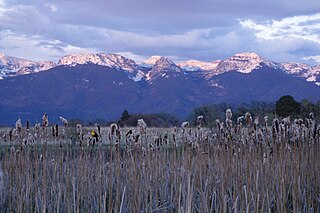
The National Bison Range Complex includes four National Wildlife Refuges and the Northwest Montana Wetland Management District, and is located in the northwestern region of Montana in the northwestern United States.

Ninepipe National Wildlife Refuge is a 4,027-acre (1,630 ha) National Wildlife Refuge and unit of the National Bison Range Complex, located in Lake County, Montana.
Pablo National Wildlife Refuge is a National Wildlife Refuge of the United States located in northwestern Montana. It is a unit of the National Bison Range Complex of refuges. It is within the Flathead Indian Reservation, about 2 mi (3.2 km) south of Polson.

Swan River National Wildlife Refuge is a 1,778-acre (720 ha) National Wildlife Refuge in Lake County of northwestern Montana. It is a unit of the National Bison Range Complex.

The National Wildlife Refuge System in the United States has a long and distinguished history.
The Crosby Wetland Management District is located in the U.S. state of North Dakota. The district is located in the extreme northwestern section of North Dakota, along the border with Canada and the state of Montana. Within the district is the Lake Zahl National Wildlife Refuge, 96 parcels of land owned by the U.S. Government which are managed as Waterfowl Production Areas, and several hundred easement refuges that are on privately owned land which are cooperatively managed by the landowners and the U.S. Fish and Wildlife Service.
The San Luis National Wildlife Refuge Complex is located in the northern San Joaquin Valley, within Merced County and Stanislaus County of California. The complex, with four federal National Wildlife Refuges, is managed by the U.S Fish & Wildlife Service.

The Sonny Bono Salton Sea National Wildlife Refuge is located in the Imperial Valley of California, 40 miles (64 km) north of the Mexican border. Situated at the southern end of the Salton Sea, the refuge protects one of the most important nesting sites and stopovers along the Pacific Flyway. Despite its location in the Colorado Desert, a subdivision of the larger Sonoran Desert, the refuge contains marine, freshwater, wetland, and agricultural habitats which provide sanctuary for hundreds of birds and wetland species, including several that have been listed as endangered or sensitive by the U.S. Fish and Wildlife Service.
The John H. Chafee National Wildlife Refuge is a national wildlife refuge of the United States, located along the Narrow River on the southern coast of Rhode Island.
Grasslands Wildlife Management Area lies within the San Joaquin River basin in California and supports the largest remaining block of wetlands in the Central Valley, containing 70,000 acres (280 km2) of private wetlands and associated, and surrounding 53,000 acres (210 km2) of state and federal lands. Perpetual conservation easements on private lands have been purchased by the United States Fish and Wildlife Service.
Big Stone Wetland Management District is a protected area encompassing scattered wetlands in Lincoln and Lyon Counties, Minnesota, United States. It is operated by the U.S. Fish and Wildlife Service out of headquarters within Big Stone National Wildlife Refuge. District staff also serve private land resource interests by providing technical assistance for United States Department of Agriculture programs and restoring wetlands on private lands.

The Summer Lake Wildlife Area is a 29.6-square-mile (77 km2) wildlife refuge located on the northwestern edge of the Great Basin drainage in south-central Oregon. It is administered by the Oregon Department of Fish and Wildlife. The refuge is an important stop for waterfowl traveling along the Pacific Flyway during their spring and fall migrations. The Summer Lake Wildlife Area also provides habitat for shorebirds and other bird species as well as wide variety of mammals and several fish species. The Ana River supplies the water for the refuge wetlands.

American Prairie is a prairie-based nature reserve in Central Montana, United States, on a shortgrass prairie ecosystem with migration corridors and native wildlife. This wildlife conservation area is being developed as a private project of the American Prairie Foundation (APF), a non-profit organization. As of 2024, the reserve habitat base covers a total 527,068 acres (213,297 ha). This includes 140,552 deeded acres and 386,516 leased acres from public land. The organization hopes to expand it greatly through a combination of both private and public lands.
