Yuzawa is a city located in Akita Prefecture, Japan. As of 31 January 2023, the city had an estimated population of 41,404 in 17551 households and a population density of 52 persons per km2. The total area of the city is 790.91 km2 (305.37 sq mi). Yuzawa claims to be the birthplace of the famous Heian period poet Ono no Komachi.

Yamagata is the capital city of Yamagata Prefecture located in the Tōhoku region of northern Japan. As of 1 August 2023, the city had an estimated population of 242,505 in 103,165 households, and a population density of 636 persons per km². The total area of the city is 381.58 square kilometres (147 sq mi).

Yonezawa is a city in Yamagata Prefecture, Japan. As of 1 February 2020, the city had an estimated population of 81,707 in 33,278 households, and a population density of 150 persons per km2. The total area of the city is 548.51 square kilometres (212 sq mi). Yonezawa is most famous for its local delicacies and for being a castle town that was once home to the Uesugi clan, including the daimyō Uesugi Yozan.

Shinjō is a city in Yamagata Prefecture, Japan. As of 1 January 2020, the city had an estimated population of 34,937, and a population density of 160 persons per km2. The total area of the city is 223.08 km2.

Murayama is a city located in Yamagata Prefecture, Japan. As of 1 February 2020, the city had an estimated population of 23,643 in 8133 households, and a population density of 120 persons per km². The total area of the city is 196.98 square kilometres (76 sq mi).

Nagai is a city located in Yamagata Prefecture, Japan. As of 1 February 2020, the city had an estimated population of 26,466 in 9940 households, and a population density of 120 people per km². The total area of the city is 214.67 square kilometres (83 sq mi).

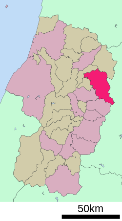
Higashine is a city located in Yamagata Prefecture, Japan. As of 1 February 2020, the city had an estimated population of 47,910 in 17868 households, and a population density of 230 persons per km². The total area of the city is 207.17 square kilometres (80 sq mi).

Nishikawa is a town located in Yamagata Prefecture, Japan. As of 1 February 2020, the town had an estimated population of 5,225 in 1851 households, and a population density of 145.1 persons per km². The total area of the town is 393.19 square kilometres (152 sq mi).

Ōe is a town located in Yamagata Prefecture, Japan. As of 1 February 2020, the town had an estimated population of 7,894 in 2828 households, and a population density of 51 persons per km2. The total area of the town is 153.92 square kilometres (59 sq mi).

Ōishida is a town located in Yamagata Prefecture, Japan. As of 1 January 2020, the town had an estimated population of 6,945 in 2348 households, and a population density of 87 persons per km2. The total area of the town is 79.54 square kilometres (31 sq mi).
Kaneyama is a town located in Yamagata Prefecture, Japan. As of 1 January 2020, the town has an estimated population of 5,205, and a population density of 35 persons per km². The total area of the town is 161.79 square kilometres (62 sq mi).

Mogami is a town in Yamagata Prefecture, Japan. As of 29 February 2020, the town has an estimated population of 8,441 in 2,848 households, and a population density of 26 persons per km2. The total area of the town is 330.27 square kilometres (128 sq mi).

Funagata is a town located in Yamagata Prefecture, Japan. As of 1 January 2020, the town has an estimated population of 5,101, and a population density of 43 persons per km². The total area of the town is 119.03 square kilometres (46 sq mi).

Mamurogawa is a town located in Yamagata Prefecture, Japan. As of 31 March 2023, the town has an estimated population of 6,792 in 2560 households, and a population density of 18 persons per km². The total area of the town is 374.22 square kilometres (144 sq mi).

Ōkura is a village in Yamagata Prefecture, Japan. As of January 2020, the village has an estimated population of 3044, and a population density of 14 persons per km2. The total area is 211.59 square kilometres (82 sq mi).
Takahata is a town located in Yamagata Prefecture, Japan. As of 1 April 2019, the town had an estimated population of 23,367, in 7629 households, and a population density of 130 persons per km2. The total area of the town is 180.26 square kilometres (70 sq mi).
Semboku is a city located in Akita Prefecture, Japan. As of 31 January 2023, the city had an estimated population of 24,045 in 10,398 households, and a population density of 22 persons per km2. The total area of the city is 1,093.56 square kilometers (422 sq mi).

Zaō is a town located in Miyagi Prefecture, Japan. As of 31 March 2020, the town had an estimated population of 11,790, and a population density of 77 persons per km2 in 4,493 households. The total area of the town is 152.84 square kilometres (59.01 sq mi).

Shōnai is a town located in Yamagata Prefecture, Japan. As of 29 February 2020, the town has an estimated population of 20,940 in 7108 households, and a population density of 87.5 per km². The total area of the town is 249.17 square kilometres (96 sq mi).

Tainai is a city located in Niigata Prefecture, Japan. As of 31 December 2020, the city had an estimated population of 28,495 in 10,821 households, and a population density of 110 persons per km2. The total area of the city was 264.89 square kilometres (102.27 sq mi).