Attur or Aathur is a town, municipality and headquarters of Attur taluk in the Salem district in the state of Tamil Nadu, India. As of the 2011 census, the town had a population of 61,793.
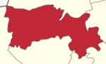
Salem District is one of the 38 districts of Tamil Nadu state in southern India. The district is now divided into Dharmapuri, Krishnagiri, Namakkal as individual districts. Salem is the district headquarters and other major towns in the district include Mettur, Thammampatti, Attur, Omalur, Sankagiri and Edappadi. That Salem dates to at least two thousand years ago is evident from the discovery of silver coins from the Roman Emperor Nero Claudius Caesar Augustus Germanicus found by Koneripatti of Salem in 1987. It was ruled by Mazhavar King Kolli Mazhavan and kings Adhiyaman and Valvil Ori of Sangam age. It is part of Kongu Nadu and Mazhanadu, a vast region that dates to the 2nd century BCE. Salem was the largest district of Tamil Nadu. It was bifurcated into Salem and Dharmapuri districts in 1965 and Namakkal district in 1997. Now Salem has been developed a lot by building many bridges and is considered to be the smart city. Salem is famous for cultivating mangoes.

Edappadi is one of the developing towns and a municipality in Salem district in the state of Tamil Nadu, India. Edappdi was once known for its thriving powerloom industry. The economy is diversified. The main modes of income are agriculture, lorry & heavy truck transport, granite, textile powerloom, entertainment and foundry. It is the second largest town in Salem Dt. next to Attur. The rocks around Edappadi are expected to contain rare minerals. The name is derived from a group of family names 'Edayar'. Now it is an ideal place for peaceful life and harmony synchronized with natural living. Water is supplied by the Cauvery river and 'Periya-yeri' (Big-lake) near Edappadi. It is surrounded by many lakes like, Periyayeri, ChettiYeri, Punka-yeri, Reddipatti-Yeri, Kavadikaranoor-Yeri. It is an Ideal spot for Cinema shootings. As of 2011, the town had a population of 55,385.special for minister area. All ways are connected with super road support.
Gangavalli is a panchayat town in Salem district in the state of Tamil Nadu, India.
Kolathur is a medium-sized town in Salem district in the Indian state of Tamil Nadu. It is located near mettur and surrounded by cavery river. The market will be held only on Fridays, so the market called as friday market.There the agriculturists surrounded near by areas sells their products and their cattle. So the market is very popular in this area. The Pannavadi Parisal Thurai is a popular tourist spot and so many people visits during Sundays for buying fish and entertainment. The underwater Nandi statue is visible during when the water level decreased. There are more people who depend on agriculture than other business around Kolathur. This is considered to be one of the developing areas. The nearby villages are Pannavadi, Moolakadu, Neethipuram, Karungaloor, Kaveripuram.

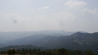
O' Valley or Ouchterlony Valley is a Town Panchayat in the Gudalur Taluk of The Nilgiris district in the Indian state of Tamil Nadu. The name is a contraction of an older name after a James Ouchterlony, who established coffee plantations in the area. This panchayat area is surrounded with beautiful mountains and the waterfalls from the mountains add to the visual treat. One can enjoy by seeing cardamom, clove, pepper, tea and coffee plantations on the way to O' Valley. The place being located between Mudumalai National Park and New Amarambalam Reserved Forest, is famous for its flora and fauna. The place is surrounded by valleys, streams and water falls of which the sound is very soothing and is a mesmeric effect.
Sendarapatti, also known as Senthalai, is a panchayat town in Salem district in the Indian state of Tamil Nadu.

Vennanthur or Vennandur is a town panchayat in Vennandur block in Rasipuram taluk of Namakkal district in the state of Tamil Nadu, India. The town panchayat office and market place are located in the heart of Vennanthur. The major occupations of the people are Tapioca Sago food manufacturing, textile weaving and agriculture.
Mullipallam is a panchayat village in Vadipatti Taluka of Madurai district, Tamil Nadu, India, with a total of 2173 families residing.
Attur Taluk is one of the taluks, or administrative division of Salem District in the state of Tamil Nadu, India. The division's headquarters is Attur town.
Naduvalur is a village in Gangavalli in the Salem district of the state of Tamil Nadu, located in the north central part of the southernmost state of India.
Thirumakkottai is a village in Mannargudi municipality in Thiruvarur district in the Indian state of Tamil Nadu. The village is Thirumakkottai consist of many streets like North street, South street, Bazaar Street, New street, Ponniyamman Temple Street, Theradi street, Nallan Pillai street. Thirumakkottai earns a good amount of foreign money through its globally spread out community. Most families have at least one member working abroad. Most of them are in Singapore, Fewer people live in this country America, Canada, London, Malaysia, Australia, Saudi Arabia, Dubai and Kuwait.

Peikkarumbankottai is a village in the Orathanadu taluk of Thanjavur district, Tamil Nadu, India.
Midalam is a village in Killiyur block in Kaniyakumari District of Tamil Nadu, India. It is located 27 km towards west from District headquarters Nagercoil, 741 km from State capital Chennai, 55 km from Thiruvananthapuram, the capital of Kerala. It shares border with Enayam and Thengapattanam at the west, Kurumpanai and Colachel at the east, Karungal at the north and Arabian Sea to the south.

Karipatti is the one of the most developed villages in the Salem district of Tamil Nadu, India. It is located 15 km towards East from District headquarters Salem. 6 km from Ayodhiyapattinam. 308 km from State capital Chennai. Karipatti Pin code is 636106 and postal head office is Karipatti. Tamil is the Local Language here. National Highway 68 is pass through this village. It is one of the important highways in Tamil Nadu which is connecting the district headquarters Salem to the state headquarters Chennai. A Karipatti Police Station is located in this village.
Kalathur.T is a Panchayat village in Karaikudi Assembly, Kannankudi union and Devakottai Taluk of Sivaganga district in the Indian state of Tamil Nadu.
Puduvoyal is a village panchayat located in the Thiruvallur district of Indian state of Tamil Nadu.

Bainapur is a small size village in Phillaur tehsil of Jalandhar district of Punjab State, India. It is located 25 km away from Phillaur, 5.8 km from Nurmahal, 27.7 km from district headquarter Jalandhar and 147 km from state capital Chandigarh. The village is administrated by a sarpanch who is an elected representative of village as per Panchayati raj (India).

Dooniwari or Dooniwara is a village in Budgam district of Indian union territory of Jammu and Kashmir, situated 8 km (5.0 mi) away from Srinagar city and 18 km (11 mi) away from Budgam town. The total geographical area of village is 168 ha. Dooniwari has a total population of 1,839 citizens. There are about 278 houses in Dooniwari village as per 2011 census. Areas in its locality include Wathoora, Gopalpora, Chattergam, Kralapora and Bagati Kani Pora.