Ohagro

Last updated
Ohagro
Loch Laxavat Ard - geograph.org.uk - 199995.jpg
Loch Laxavat Ard, with the Abhainn Othagro flowing into the loch in the right foreground
Outer Hebrides UK location map.svg
Red pog.svg
Ohagro
Location within the Outer Hebrides
Language Scottish Gaelic
English
OS grid reference NB242394
Council area
Country Scotland
Sovereign state United Kingdom
Police Scottish
Fire Scottish
Ambulance Scottish
EU Parliament Scotland
UK Parliament
Scottish Parliament
List of places
UK
Scotland
58°15′N6°42′W / 58.25°N 6.70°W / 58.25; -6.70 Coordinates: 58°15′N6°42′W / 58.25°N 6.70°W / 58.25; -6.70

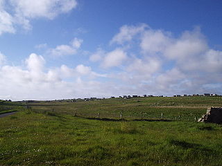
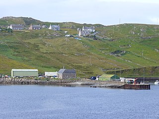
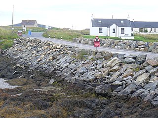
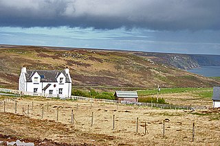
Ohagro is a seasonal settlement on the Isle of Lewis in the Outer Hebrides, Scotland. The area is occupied by shieling huts. [1]

Isle of Lewis northern part of the Scottish island Lewis and Harris

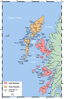
Lewis is the northern part of Lewis and Harris, the largest island of the Western Isles or Outer Hebrides archipelago in Scotland. It is also known as the Isle of Lewis, as the two parts are frequently referred to as if they were separate islands. The total area of Lewis is 683 square miles (1,770 km2).

Outer Hebrides archipelago and council area off the west coast of mainland Scotland

The Outer Hebrides, also known as the Western Isles, Innse Gall or the Long Isle/Long Island, is an island chain off the west coast of mainland Scotland. The islands are geographically coextensive with Comhairle nan Eilean Siar, one of the 32 unitary council areas of Scotland. They form part of the archipelago of the Hebrides, separated from the Scottish mainland and from the Inner Hebrides by the waters of the Minch, the Little Minch, and the Sea of the Hebrides. Scottish Gaelic is the predominant spoken language, although in a few areas English speakers form a majority.

Shieling mountain pasture

A shieling, also spelt sheiling, shealing and sheeling, is a hut, or collection of huts, once common in wild or lonely places in the hills and mountains of Scotland and northern England. The word also refers to a mountain pasture used for the grazing of cattle in summer, implying transhumance between there and a valley settlement in winter.

Related Research Articles

Callanish village in the United Kingdom

Callanish is a village (township) on the west side of the Isle of Lewis, in the Outer Hebrides, Scotland. Callanish is within the parish of Uig. A linear settlement with a jetty, it is on a headland jutting into Loch Roag, a sea loch 13 miles west of Stornoway. Callanish is situated alongside the A858, between Breasclete and Garynahine.

The Minch strait between the Inner and Outer Hebrides, Scotland

The Minch, also called North Minch, is a strait in north-west Scotland, separating the north-west Highlands and the northern Inner Hebrides from Lewis and Harris in the Outer Hebrides. It was known as Skotlandsfjörð in Old Norse.

Barvas settlement, community and civil parish on the Isle of Lewis in Scotland

Barvas is a settlement, community and civil parish on the Isle of Lewis in Scotland.

Skigersta village in United Kingdom

Skigersta is a village to the south east of Ness on the Isle of Lewis, in the Outer Hebrides, Scotland. Skigersta is situated within the parish of Barvas. There is a quay built in 1901 and a shingle beach. Skigersta was a location for fish curing in the 19th century with the ruins of the curing bothies still visible next to the river and a man-made channel in the shoreline allowing easier access for the boats. The area of Skigersta near the shore is called 'Lachamore'.

Breasclete village in United Kingdom

Breasclete is a village and community on the west side of the Isle of Lewis, in the Outer Hebrides, Scotland. Breasclete is within the parish of Uig, and is situated adjacent to the A858.

Bayble village in United Kingdom

Bayble is a large village in Point, on the Isle of Lewis, 6 miles (10 km) east of the town of Stornoway. Bayble is also within the parish of Stornoway.

Leurbost village on the Isle of Lewis, Scotland, United Kingdom

Leurbost is a village on the east coast of the Isle of Lewis in the Outer Hebrides of Scotland. It is approximately 6 miles (10 km) south of Stornoway on the road to Harris. It is the main settlement in the area of the island known as North Lochs. Leurbost is within the parish of Lochs.

Adabroc village in United Kingdom

Adabrock, is a village in the area of Ness, Lewis, in the Outer Hebrides, Scotland. Adabrock is within the parish of Barvas, and is situated on the B8015 between Lionel and Eorodale. It is at the northern tip of Lewis, south-west of Port of Ness.

Garrabost village on the Isle of Lewis, Scotland, United Kingdom

Garrabost is a village in the Point peninsula isthmus on the east coast of the Isle of Lewis, in the Outer Hebrides, Scotland. The village is one of the largest in Point, comprising Upper and Lower Garrabost, and Claypark. Garrabost is within the civil parish of Stornoway. The church parish for Point is called Knock, and both Knock Church of Scotland and Knock Free Church of Scotland are located in Garrabost. Garrabost is situated on the A866, between Stornoway and Portnaguran.

Ardroil village in United Kingdom

Ardroil is a village on the Isle of Lewis in the Outer Hebrides, Scotland. Ardroil is within the parish of Uig.

Borrowston, Lewis village in United Kingdom

Borrowston is a crofting township situated on the Isle of Lewis, on the Outer Hebrides of Scotland. It lies at the northern end of Loch Carloway 0.5 miles (0.80 km) west of Carloway. Borrowston is within the parish of Uig, and is situated near to the A858, which runs through Carloway.

Baile an Truiseil village in United Kingdom

Ballantrushal is a village on the Isle of Lewis in the West Side district, in the Outer Hebrides, Scotland. Ballantrushal is within the parish of Barvas, and is situated on the A857. The standing stone Clach an Trushal is beside the village. and was the site of the last battle between the Lewis Macaulays and Morrison clans.

Baile Glas village in United Kingdom

Baile Glas or Ballaglasa is a settlement on Grimsay in the Outer Hebrides, Scotland. Ballaglasa is within the parish of North Uist.

New Tolsta village in United Kingdom

New Tolsta is a village on the Isle of Lewis in the Outer Hebrides, Scotland. New Tolsta is within the parish of Stornoway, and it lies to the north of North Tolsta, at the end of the B895 road.

Calbost village in United Kingdom

Calbost is a village on the Isle of Lewis in the Outer Hebrides, Scotland. Calbost is within the parish of Lochs, and within the district of Pairc.

Cross, Lewis village in United Kingdom

Cross is a township on the Isle of Lewis in the community of Ness, in the Outer Hebrides, Scotland. Cross is within the parish of Barvas. Cross is also situated on the A857, between Stornoway and Port of Ness.

Cliff, Lewis village in United Kingdom

Cliff is a small settlement on the Isle of Lewis, in the Outer Hebrides, Scotland. Cliff is within the parish of Uig. The settlement is situated on a minor road, off the B8011. The picturesque beach is unsafe for swimming. At low to mid tide holds an excellent barrelling beach break wave. Breaks up to 12 ft+ for experienced surfers and bodyboarders

Timsgarry village in United Kingdom

Timsgarry is a village on the Isle of Lewis, in the Outer Hebrides, Scotland. Timsgarry is home to the Baile na Cille Church, and is situated within the parish of Uig. Timsgarry used to have its own chapel, named Capail Mor, further to the west of the present church, which was built in 1724 near to the site of an earlier church, known as Capail Beag. The former manse is still present, with the churchyard. Fragments of Iron Age pottery were recovered from Dun Borranish, just to the south of the main settlement, in 1991. The Uig Museum is located at Timsgarry, within the community centre, and displays local archaeology, such as the Uig Chessmen.

Marybank, Lewis village in United Kingdom

Marybank is a settlement on the outskirts of Stornoway, Isle of Lewis in the Outer Hebrides of Scotland. It is also within the parish of Stornoway. Marybank is situated at the junction of the A858 and A859. Lews Castle and Stornoway Golf Club are to the east of Marybank.

Tolsta Chaolais village in United Kingdom

Tolsta Chaolais is a village on the Isle of Lewis, Scotland. It consists of about forty houses, clustered around Loch a' Bhaile, about a mile from the A858 road between Callanish and Carloway. The name has a Norse element, Tolsta, combined with a Gaelic element, Caolas, and means "Farm by the Strait". Tolsta Chaolais is in the parish of Uig, and has a building as a place of worship for all denominations.

References

  1. "Lewis, Sidhean Ohagro". Royal Commission on the Ancient and Historical Monuments of Scotland . Retrieved 20 December 2014.