Related Research Articles

Kaipara Harbour is a large enclosed harbour estuary complex on the north western side of the North Island of New Zealand. The northern part of the harbour is administered by the Kaipara District and the southern part is administered by the Auckland Council. The local Māori tribe is Ngāti Whātua.
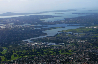
The Tāmaki River or Tāmaki Estuary is mostly an estuarial arm and harbour of the Hauraki Gulf, within the city of Auckland in New Zealand. It extends south for 15 kilometres (9 mi) from its mouth between the suburb of Saint Heliers and the long thin peninsula of Bucklands Beach, which reaches its end at Musick Point. The inlet extends past the suburbs of Glendowie, Wai o Taiki Bay, Point England, Glen Innes, Tāmaki, Panmure, and Ōtāhuhu to the west, and Bucklands Beach, Half Moon Bay, Farm Cove, Sunnyhills and Pakuranga to the east.

The Whau River is an estuarial arm of the southwestern Waitemata Harbour within the Auckland metropolitan area in New Zealand. It flows north for 5.7 kilometres (3.5 mi) from its origin at the confluence of the Avondale Stream and Whau Stream to its mouth between the Te Atatū peninsula and the long, thin Rosebank Peninsula in Avondale. It is 800 metres (2,600 ft) at its widest and 400 metres (1,300 ft) wide at its mouth.
The Hibiscus Coast is a populated area on a stretch of the Hauraki Gulf coast in New Zealand's Auckland Region. It has a population of 60,000, making it the 11th most populous urban area in New Zealand, and the second most populous in the Auckland Region, behind Auckland itself.
The Mahurangi River in northern New Zealand flows through the town of Warkworth and into Mahurangi Harbour, which opens into the outer Hauraki Gulf. The Left Branch of the river rises in the Dome and flows through the Dome Valley, while the Right Branch rises on Moir Hill. The lower part is a tidal estuary that ranges in depth from below approximately 50 centimetres at the channel entrance to approximately 150 centimetres further upstream. The Mahurangi Harbour provides a sheltered anchorage for private pleasure craft in all weathers.

Great Bay is a tidal estuary located in Strafford and Rockingham counties in eastern New Hampshire, United States. The bay occupies over 6,000 acres (24 km2), not including its several tidal river tributaries. Its outlet is at Hilton Point in Dover, New Hampshire, where waters from the bay flow into the Piscataqua River, thence proceeding southeast to the Atlantic Ocean near Portsmouth. The northern end of the bay, near its outlet, is referred to as Little Bay.

Stillwater is a village in the northern end of Auckland in the North Island of New Zealand. Situated on the Weiti River immediately south of the Whangaparaoa Peninsula in the Rodney District, it is part of the area known as the Hibiscus Coast. There is also a Stillwater, West Coast in the South Island.

The Weiti River is an estuarine river to the north of Auckland in the North Island of New Zealand. It rises as the Weiti Stream in the low hills approximately 7 kilometres (4 mi) west of Silverdale and emerges into the Hauraki Gulf immediately south of the Whangaparaoa Peninsula. The upper stretches of the river are heavily grown with mangroves but with care, small craft can navigate it as far as Silverdale at high tide. Stillwater is the only other settlement along the river's banks. Wentworth College, based in nearby Gulf Harbour, uses the Weiti River for its rowing training.
Ōkura is a northern suburb of the North Shore, part of the contiguous metropolitan area in Auckland, New Zealand. It is under the local governance of the Auckland Council. The official name is spelled with a macron.

Meola Creek is a waterway in Auckland, New Zealand. It is situated in Integrated Catchment Area #1 within Auckland City's drainage network. The catchment consists largely of a natural valley that runs down from the north-east slopes of Mt Albert (Owairaka), north of Mt Albert Road. The upper section of Meola Creek flows along the boundary of the Western Springs College and through the Kerr-Taylor Reserve. The area around the creek is subject to a combination of residential, commercial and recreational activities, which result in the stream being entirely piped upstream of the Chamberlain Park Golf Course, and strongly contaminated with urban pollutants such as zinc and lead.

Long Bay is one of the northernmost suburbs of the North Shore, part of the contiguous Auckland metropolitan area located in New Zealand.
Long Bay Regional Park is a regional park in Long Bay located in Auckland, New Zealand. It is located in the Hibiscus and Bays in the northern part of the city and is operated by Auckland Council.
The Long Bay-Okura Marine Reserve is a 980-hectare (2,400-acre) protected area at Long Bay on the North Shore in the Auckland Region of New Zealand. It was created by Order in Council in 1995.

Ulva Island-Te Wharawhara Marine Reserve is a marine reserve covering an area of 1,075 hectares south-west and north-east of Ulva Island, in the Paterson Inlet of New Zealand's Stewart Island. It was established in 2004 and is administered by the Department of Conservation.
Pohutukawa Bay is a beach north of Long Bay, located on the North Shore of Auckland. It is situated northeast of Okura, close to Piripiri Point. Directly south of Pohutukawa Bay Beach is Granny's Bay Beach, and a little further south is Long Bay Regional Park. The beach is accessible only at low tide, and it is among one of Auckland's most popular naturist beaches. Public nudity is technically legal on any New Zealand beach where it is "known to occur". Getting to the beach requires going through the coastal track, a 6 km (3.7 mi) walk that starts from the beach carparks, and ends at the Okura River.

Te Matuku Marine Reserve is a marine reserve administered by the New Zealand Department of Conservation. It includes Te Matuku Bay, one of the largest and least disturbed estuaries on Waiheke Island, as well as a surrounding area of sea. It covers an area of 690 ha and was established in 2003.
Te Matuku Bay is a bay on Waiheke Island in New Zealand's Hauraki Gulf. It is one of the largest and least disturbed estuaries on the island. Since 2003, the area has been protected as part of Te Matuku Marine Reserve.
Te Angiangi Marine Reserve is a marine reserve covering a marine area of 446 hectares in the Hawke's Bay Region of New Zealand's North Island. It was established in 1997 and is administered by the Department of Conservation.

Northern Pegasus Bay is a regional park in the northern part of Canterbury's Pegasus Bay in New Zealand's South Island. It is operated by Environment Canterbury.

The Whangateau Harbour is a natural harbour in New Zealand. It is a sandspit estuary, located on the north-eastern coast of the Auckland Region north-east of Matakana, and empties into the Hauraki Gulf. Due to the harbour's high quality water and dense shellfish beds, the harbour is a popular spot for shellfish gathering.
References
- 1 2 Cameron, Ewen; Hayward, Bruce; Murdoch, Graeme (2008). A Field Guide to Auckland: Exploring the Region's Natural and Historical Heritage (rev. ed.). Random House New Zealand. p. 132. ISBN 978-1-86962-1513.
- ↑ "Acres of shellfish dead in north Auckland estuary". Newshub. 14 May 2018. Archived from the original on 17 May 2018. Retrieved 15 May 2018.