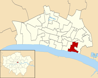
Billingsgate is one of the 25 Wards of the City of London. This small City Ward is situated on the north bank of the River Thames between London Bridge and Tower Bridge in the south-east of the Square Mile.

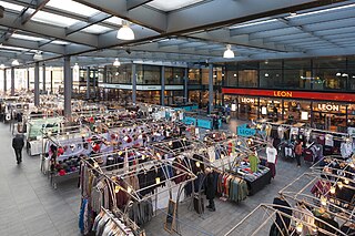
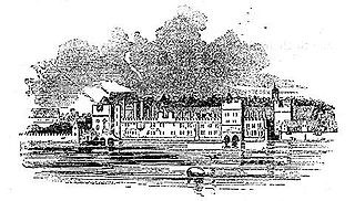
Billingsgate Fish Market is located in Poplar in London. It is the United Kingdom's largest inland fish market. It takes its name from Billingsgate, a ward in the south-east corner of the City of London, where the riverside market was originally established. In its original location in the 19th century, Billingsgate was the largest fish market in the world.

New Spitalfields Market is a fruit and vegetable market on a 31-acre (13 ha) site in Leyton, London Borough of Waltham Forest in East London. The market is owned and administered by the City of London Corporation. The market is Europe's leading horticultural market specialising in exotic fruit and vegetables - and the largest revenue earning wholesale market in the UK.

Shad Thames is a historic riverside street next to Tower Bridge in Bermondsey, London, England, and is also an informal name for the surrounding area. In the 19th century, the area included the largest warehouse complex in London.

The Metropolitan Cattle Market, just off the Caledonian Road in the parish of Islington was built by the City of London Corporation and was opened in June 1855 by Prince Albert. The market was supplementary to the meat market at Smithfield and was established to remove the difficulty of managing live cattle at that latter site.

Charterhouse Street is a street on the north side of Smithfield in the City of London. The road forms part of the City’s boundary with the neighbouring London Boroughs of Islington and Camden. It connects Charterhouse Square and Holborn Circus, crossing Farringdon Road and running along a number of historical sites, including Smithfield Market.
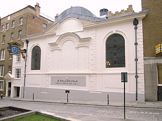
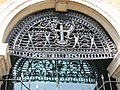
St Mary-at-Hill is a Church of England parish church in the Ward of Billingsgate, City of London. It is situated on Lovat Lane, a cobbled street off Eastcheap.

Hungerford Market was a produce market in London, at Charing Cross on the Strand. It existed in two different buildings on the same site, the first built in 1682, the second in 1832. The market was first built on the site of Hungerford House, next to Durham Yard, the town house of the Hungerford family. The house had burned down in 1669 as is recorded in the Diary of Samuel Pepys. It was replaced by a new Italianate market building by Charles Fowler, which opened in 1833. The new market was unsuccessful. It was damaged when the adjoining Hungerford Hall burned down in 1854, and was sold to the South Eastern Railway in 1862. Charing Cross railway station was built on the site and opened in 1864.

St George Botolph Lane was a church off Eastcheap, in the ward of Billingsgate in the City of London. The rear of the church overlooked Pudding Lane, where the fire of London started. It was first recorded in the twelfth century, and destroyed in the Great Fire of 1666. It was one of the 51 churches rebuilt by the office of Sir Christopher Wren. The church was demolished in 1904.

St Botolph's, Billingsgate was a Church of England parish church in London. Of medieval origin, it was located in the Billingsgate ward of the City of London and destroyed by the Great Fire of London in 1666.
Spitalfields Market is a traders' market as well as a food and art market located in Spitalfields, Central London. Traders began operating around 1666, after the Great Fire of London, where the market stands today. The Spitalfields regeneration programme that ended in 2005, resulted in two new public spaces – Bishops Square and Crispin Place, which restored several historic streets and resulted in more independent retailers and restaurants. Spitalfields Market is situated in the London Borough of Tower Hamlets. It is surrounded by Lamb Street, Old Spitalfields market, Brushfield Street and Bishops Square.
Savoy Place is a large red brick building on the north bank of the River Thames in the City of Westminster. It is on a street called Savoy Place; Savoy Hill and Savoy Street run along the sides of the building up to the Strand. In front is the Victoria Embankment, part of the Thames Embankment. Close by are Savoy Hill House, the Savoy Hotel and Waterloo Bridge. There are commanding views over to the South Bank and the London Eye.

Baynard House is a brutalist office block in Queen Victoria Street in Blackfriars in the City of London, occupied by BT Group. It was built on the site of Baynard's Castle. Most of the land under it is a scheduled monument. From 1982 to 1997 it housed the BT Museum.

The Dimco Buildings are a pair of 19th-century structures in White City, London, just north of Shepherd's Bush. Originally built in 1898 as an electric railway power station, they are now in use as a bus station.

The London Coal Exchange was situated on the north side of Thames Street in the City of London, nearly opposite to Old Billingsgate Market, occupying three different structures from 1770 to 1962. The original coal exchange opened in 1770. A second building from 1805 was replaced by a new purpose-built structure constructed from 1847 to 1849, and opened by Prince Albert on 30 October 1849. This third London coal exchange was one of the first substantial buildings constructed from cast iron, built several years before the hall at the Great Exhibition. It was demolished in 1962 to allow widening of what is now Lower Thames Street despite a campaign by the Victorian Society to save the building. Cast iron decorations from the 1849 Coal Exchange building were selected as the model for the dragon boundary mark for the main entrances to the City of London.
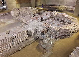
Billingsgate Roman House and Baths is an archaeological site in Londinium. The best preserved parts of the house are a bath with hypocausts. The ruins were discovered in 1848 while the Coal Exchange was built on the site. The remains were preserved and were visible in the cellar of the building. In 1967 to 1970, the Coal Exchange was replaced by another building and the Lower Thames Street was enlarged. Further excavations were made at the site and the remains were incorporated into the cellar of the new building, but were not open to the public.

London Bridge Wharf was a wharf in the City of London located alongside London Bridge, just to the east of the north end of the bridge. It stood below the Adelaide Buildings and their 1925 replacement, Adelaide House. The wharf was constructed on the site of the London Bridge Waterworks, which had been demolished along with Old London Bridge in 1832. It originally handled general cargo and also passenger steamships, such as the vessels of the New Medway Steam Packet Company, which offered daily "sea cruises" along the North Kent and Essex coasts.

Cox & Hammond's Quay was a wharf located in the City of London, on the north bank of the River Thames a short distance downstream from London Bridge. It was originally two separate quays, Cox's Quay and Hammond's Quay, separated by Gaunt's Quay. On the landward side, the wharf was accessed via Lower Thames Street just behind the site of the church of St Botolph Billingsgate.
Botolph Wharf or St Botolph's Wharf was a wharf located in the City of London, on the north bank of the River Thames a short distance downstream from London Bridge. It was situated between Cox and Hammond's Quay upstream and Nicholson's Wharf downstream. On the landward side, the wharf was accessed via Thames Street. It had a frontage of 78 ft (24 m). The wharf was used for at least a thousand years before being destroyed during the Second World War. A late 1980s office building currently occupies the site.