Cradle Mountain–Lake St Clair National Park is located in the Central Highlands area of Tasmania (Australia), 165 kilometres (103 mi) northwest of Hobart. The park contains many walking trails, and is where hikes along the well-known Overland Track usually begin. Major features are Cradle Mountain and Barn Bluff in the northern end, Mount Pelion East, Mount Pelion West, Mount Oakleigh and Mount Ossa in the middle and Lake St Clair in the southern end of the park. The park is part of the Tasmanian Wilderness World Heritage Area.
The Walls of Jerusalem National Park is a national park located in the Central Highlands region of Tasmania, Australia. The park is located approximately 144 km (89 mi) northwest of Hobart, east of the Cradle Mountain-Lake St Clair National Park, and west of the Central Plateau Conservation Area. It is south of Mole Creek, Tasmania, and Rowallan Lake. The national park forms part of the Tasmanian Wilderness World Heritage Area.

Cradle Mountain is a locality and mountain in the Central Highlands region of the Australian state of Tasmania. The mountain is situated in the Cradle Mountain-Lake St Clair National Park.

The Tasmanian Wilderness World Heritage Area, abbreviated to TWWHA, is a World Heritage Site in Tasmania, Australia. It is one of the largest conservation areas in Australia, covering 15,800 km2 (6,100 sq mi), or almost 25 per cent of Tasmania. It is also one of the last expanses of temperate wilderness in the world, and includes the South West Wilderness.

Lake St Clair or leeawulenna is a natural freshwater lake located in the Central Highlands area of Tasmania, Australia. The lake forms the southern end of the Cradle Mountain-Lake St Clair National Park. It has an area of approximately 45 square kilometres (17 sq mi), and a maximum depth of 215 metres (705 ft), making it Australia's deepest lake.

Mount Ossa is the highest mountain in Tasmania, with a summit elevation of 1,617 metres (5,305 ft) above sea level. It makes up part of the Pelion Range within Cradle Mountain-Lake St Clair National Park in the Central Highlands region of Tasmania, Australia.

Central Highlands Council is a local government body in Tasmania, encompassing the Central Highlands region of the state. Central Highlands is classified as a rural local government area and has a population of 2,144, the two largest towns are Bothwell and Hamilton.

The Overland Track is an Australian bushwalking track, traversing Cradle Mountain-Lake St Clair National Park, within the Tasmanian Wilderness World Heritage Area. It is walked by more than nine thousand people each year, with numbers limited in the warmer months. Officially the track runs for 65 kilometres (40 mi) from Cradle Mountain to Lake St Clair however many choose to extend it by walking along Lake St Clair for an extra day, bringing it to 82 kilometres (51 mi). It winds through terrain ranging from glacial mountains, temperate rainforest, wild rivers and alpine plains.

Frenchmans Cap is a mountain in the West Coast region of Tasmania, Australia. The mountain is situated in the Franklin-Gordon Wild Rivers National Park.

The Central Highlands is a region in Tasmania, Australia where geographical and administrative boundaries closely coincide. It is also known as The Lake Country of Tasmania.

Mount Pelion West is a mountain located in the Central Highlands region of Tasmania, Australia. The mountain is part of the Pelion Range and is situated within the Cradle Mountain-Lake St Clair National Park at the easternmost boundary of the Murchison River catchment.

Mount Pelion East is a mountain located in the Central Highlands region of Tasmania, Australia. The mountain is situated within the Cradle Mountain-Lake St Clair National Park.

Pelion Gap is the mountain pass between Mount Doris and Mount Ossa to the south and Mount Pelion East to the north through which the Overland Track in Tasmania passes.
Mount Thetis is a mountain in the Central Highlands region of Tasmania, Australia. It is part of the Pelion Range and is situated within the Cradle Mountain-Lake St Clair National Park. It is a major feature of the national park, and is a popular venue with bushwalkers and mountain climbers.

New Pelion Hut is the largest alpine hut in the Cradle Mountain-Lake St Clair National Park in the Central Highlands of Tasmania, Australia

Waterfall Valley Hut is located in the Cradle Mountain National Park, Tasmania, Australia. It is the most northerly of six overnight huts located along the Overland Track. The current rendition of the hut was opened in 2020. It sleeps up to 34 people across three different rooms. There is also a fourth room which houses tables and bench seats for cooking and eating, and a wet area for leaving gear. It is heated by a small gas heater.
The Pelion Range is a mountain range in the Cradle Mountain-Lake St Clair National Park, Tasmania, Australia.

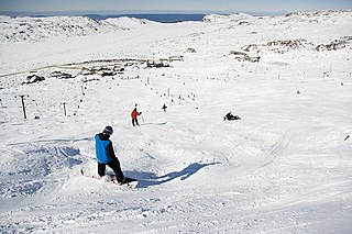
Skiing in Tasmania takes place in the high country of the state of Tasmania, Australia, during the Southern Hemisphere winter. Cross country skiing is possible within the Tasmanian Wilderness and two small downhill ski-fields have been developed at Ben Lomond and Mount Mawson.

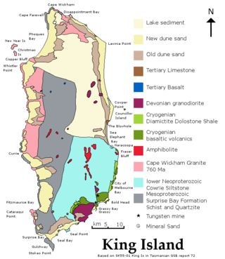
Lavinia State Reserve, formerly Lavinia Nature Reserve, is a 68 km2 protected area on King Island, lying at the western end of Bass Strait and belonging to the Australian state of Tasmania.
Quamby Estate is a country homestead situated on 150 acres in Tasmania's Meander Valley. The estate is a Tasmanian historically important property and dates back to 1828. Quamby was the home of Sir Richard Dry, a premier of Tasmania and the first native-born premier and knight in any Australian colony. The property is now a commercial luxury lodge.


