Old Stephensburg, Kentucky | |
|---|---|
 Old Stephensburg  Old Stephensburg | |
| Coordinates: 37°36′52″N86°01′13″W / 37.61444°N 86.02028°W | |
| Country | United States |
| State | Kentucky |
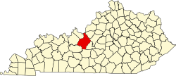
| County | Hardin |
| Elevation | 686 ft (209 m) |
| Time zone | UTC-5 (Eastern (EST)) |
| • Summer (DST) | UTC-4 (EDT) |
| Area code(s) | 270 & 364 |
| GNIS feature ID | 499886 [1] |
Old Stephensburg is an unincorporated community in Hardin County, Kentucky, United States. [1]