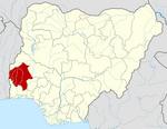
Oyo State is an inland state in southwestern Nigeria. Its capital is Ibadan, the third most populous city in the country and formerly the second most populous city in Africa. Oyo State is bordered to the north by Kwara State for 337 km, to the east by Osun State for 187 km, partly across the River Osun, and to the south by Ogun State, and to the west by the Republic of Benin for 98 km. With a projected population of 7,976,100 in 2022, Oyo State is the sixth most populous in the Nigeria.
Yenagoa is a Local Government Area and capital city of Bayelsa State, southern Nigeria. It is located at the southern part of the country at coordinates 4°55′29″N6°15′51″E.
Ogoja is a Local Government Area in Cross River State, Nigeria. Its headquarters is Ogoja town in the northeast of the area near the A4 highway at 6°39′17″N8°47′51″E.
Dutse is the capital city of Jigawa State in northern Nigeria, and also the capital of Dutse Emirate. It is a home to Federal University, Dutse established in November 2011. In addition to the Federal University Dutse, there is also a Research Institute for Date Palm (Sub-Station) and state polytechnic in Dutse. The Jigawa State Polytechnic has its College of Business and Management Studies at Dutse.

Iseyin is a city located in Oyo, Nigeria. It is approximately 100 km (62 mi) north of Ibadan. The city was estimated to have a population of 236,000, according to United Nations 2005 estimate, which increased to 362,990 in 2011, and has a total land mass of 2,341 km2 (904 sq mi). Its inhabitants are mostly of Yoruba origin and its ruler is the Aseyin of Iseyin, with the current being Oba Sefiu Oyebola Adeyeri III, Ajirotutu I.
Suleja is a city in Niger State, Nigeria, pop. (2016) local government area, 260,240, just north of Abuja, capital of the Suleja Emirate. It is sometimes confused with the nearby city of Abuja, due to its proximity, and the fact that it was originally called Abuja before the Nigerian government adopted the name from the then Emir Sulayman Bal for its new federal capital in 1976.
The Old Oyo National Park is one of the national parks of Nigeria, located across northern Oyo State and southern Kwara State, Nigeria. The park is 2,512 km2 of land in northern Oyo state, south west Nigeria, at latitude 8° 15’ and 9° 00’N and longitude 3° 35’ and 4° 42’ E. The location has inevitably placed the park at a vantage position of abundance land area as well as diverse wildlife and cultural/historical settings. Eleven local government areas out of which ten fall within Oyo State and one in Kwara State surrounds it. The Administrative Head Office is located in Oyo, Isokun area along Oyo-Iseyin road, where necessary information and booking could be made. The landscaping and organized space within the large yard has made the facility very endearing to the public. It is rich in plant and animal resources including buffaloes, bushbuck and a variety of birds. The park is easily accessible from southwestern and northwestern Nigeria. The nearest cities and towns adjoining Old Oyo National Park include Saki, Iseyin, Igboho, Sepeteri, Tede, Kishi, and Igbeti, which have their own commercial and cultural attractions for tourism.
Agaie is a Local Government Area in Niger State, Nigeria. Its headquarters are in the town of Agaie on the A124 highway.
Demsa is a Local Government Area of Adamawa State, Nigeria with headquarters located in Demsa. Demsa lies on the Benue River.
Lamurde is a town and Local Government Area of Adamawa State, Nigeria inhabited predominantly by the Bwatiye (Bachama) people.

Mubi North is a Local Government Area of Adamawa State, Nigeria. The town is the location of the Adamawa State University and the Federal Polytechnic, Mubi.
Alkaleri is a Local Government Area of Bauchi State, Nigeria. Its headquarters are in the town of Alkaleri on the A345 highway in the northern part of the Local Government Area.
Kwaya Kusar is a Local Government Area of Borno State, Nigeria. Its headquarters are in the town of Kwaya Kusar.
Maigatari is a border town located in the Sahel along the Niger-Nigeria border. The town is known for its large market founded in 1870 and trading in horses, camels, cattle and other livestock between Niger, Mali, Chad and Cameroon.
Agwara is a Local Government Area in Niger State, Nigeria. Its headquarters are in the town of Agwara.

Iwajowa is a Local Government Area in Oyo State, Nigeria. Its headquarter is in the town of Iwere Ile. Iwere-ile had been a powerful war town in the old Oyo empire, dreadful for many Oyo indigenes, as well as the Alaafin to attack. Iwere-ile became the headquarters of Iwajowa Local Government Area on 4 December 1996 upon the creation of the new local government under the Gen Sanni Abacha's regime. Other town and settlements include Iganna, Ilaji-Ile, Idiko-Ile, Ayetoro Ile, Itasa, Idiko Ago, Elekookan, Ijio, Ayegun Wasimi and over 350 villages and farm settlements. The inhabitants of the area are predominantly Yoruba cohabiting peacefully with other tribes such as Fulani, Hausa, Tiv, Egede and others who engage in cattle rearing, large scale farming and hunting. This explains why food and cash crops are readily available at considerably cheap rates.
Anka is a Local Government Area in Zamfara State, Nigeria. Its headquarters is in the town of Anka at 12°06′30″N5°56′00″E.
Birnin Magaji/Kiyaw is a Local Government Area in Zamfara State, Nigeria. Its headquarters are in the town of Birnin Magaji in the north of the LGA at12°33′00″N6°49′00″E. The LGA is also named from the town of Kiyaw to the south.
Ife South is a Local Government Area in Osun State, Nigeria. Its headquarters are in the town of Ifetedo at 7°11′00″N4°42′00″E.
Apomu is a medium-sized town in the Osun state. It has a population of about 71,656 people.