Igabi is a Local Government Area (LGA) of Kaduna State, Nigeria. It is chaired by the Executive Chairman - Jabir Khamis, It is one of 774 local government areas in Nigeria. Rigasa ward is under Igabi LGA, one of the most populous wards in the state.
Konshisha is a local government area of Benue State, Nigeria. Its headquarters are in the town of Tse-Agberagba.
Ise/Orun is a Local Government Area of Ekiti State, Nigeria. Its headquarters are in the town of Ise Ekiti.

Akko is a local government area of Gombe, Gombe State, Nigeria. Its headquarters is in Kumo town on the A345 highway south of the state capital Gombe, about 40 km away. Kumo (headquarter) is a cosmopolitan communities of more than 30 differents tribes, ranging from the dominant Fulani tribe to Tangale, Tera, Hausa and other minorities.

Nafada is one of the eleven Local Government Areas (LGA) of Gombe State, Nigeria. Its headquarter is in the town of Nafada in the east of the area at 11°05′44″N11°19′58″E, on the Gongola River which traverses the area. According to the 2006 census, the LGA covers 1,586 square kilometers and has a population of 138,185 people. Nafada has ten wards namely: Nafada East, Nafada Central, Nafada West, Jigawa, Birnin Fulani East, Birnin Bolewa, Birnin Fulani West, Gudukku, Barwo/Nasarawo and Barwo Winde.

Kaiama is a Local Government Area and town in northwestern Kwara State, Nigeria. Its headquarters are in the town of Kaiama.
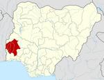
Augie is a Local Government Area in Kebbi State, Nigeria. Its headquarters are in the town of Augie.
Kafur is a Local Government Area in Katsina State, Nigeria. Its headquarters is located in the town of Kafur.

Gezawa is a Local Government Area in Kano State, Nigeria. Gezawa Local Government Area administrative headquarters is in the town of Gezawa with its area council made up of Jogana, Gawo, Zango, Tumbau, Wangara, Sarain-Gezawa, Babawa, Ketatwa and Tsamiya-Dabba. It has an area of 340 km2 and a population of 282,069 at the 2006 census. Hausa and Fulani ethnic groups make up the majority of the local population. The majority religion practiced in the region is Islam, and the languages spoken there are Fufulde and Hausa.
Rogo is a Local Government Area in Kano State, Nigeria. Its headquarter is in the town of Rogo.
Birnin Gwari is a Local Government Area in Kaduna State, Nigeria. Its headquarters are in the town of Birnin Gwari.
Chikun is a Local Government Area in central Kaduna State, Nigeria. It has an area of about 4,466 km2, and had a population of 372,272 as at the 2006 census. Its headquarters is located in the town of Kujama. The postal code of the area is 2438000.
Kaura is a town and a Local Government Area in southern Kaduna State, Nigeria. Its headquarters are in the town of Kaura in Asholyio (Moroa) Chiefdom. The Local Government Council is chaired by Matthias Siman. Other towns include: Takad (Attakar)Manchok and Kagoro. It has an area of 461 km2 and a population of 174,626 at the 2006 census. The postal code of the area is 801.
Kauru is a Local Government Area in southern Kaduna State, Nigeria. The area is 3,186 km2. Its headquarters are in the town of Kauru. The postal code of the area is 811.
Giwa Local Government Area, is a Local Government Area at Kaduna State, Nigeria. Its headquarters are in the town of Giwa. The Government Council is chaired by Abubakar Lawal.
Paikoro Local Government is one of the 774 Local Government Areas of Nigeria and one of 25 Local Government areas in Niger-State Nigeria. Paikoro Local Government headquarter is located in Paiko town about 25 km south-east of the state capital Minna.
Atiba is a Local Government Area in Oyo State, Nigeria. Its headquarters is in the town of Offa Meta.
Olorunsogo is a Local Government Area in Oyo State, Nigeria. Its headquarters are in the town of Igbeti.
Birnin Magaji/Kiyaw is a Local Government Area in Zamfara State, Nigeria. Its headquarters are in the town of Birnin Magaji in the north of the LGA at12°33′00″N6°49′00″E. The LGA is also named from the town of Kiyaw to the south.
Ife South is a Local Government Area in Osun State, Nigeria. Its headquarters are in the town of Ifetedo at 7°11′00″N4°42′00″E.