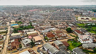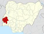
Ibadan is the capital and most populous city of Oyo State, in Nigeria. It is the third-largest city by population in Nigeria after Lagos and Kano, with a total population of 2,649,000 as of 2021, and over 3 million people within its metropolitan area. It is one of the country's largest city by geographical area. At the time of Nigeria's independence in 1960, Ibadan was the largest and most populated city in the country, and the second most populous in Africa behind Cairo. Ibadan is ranked one of the fastest growing city on the sub Shara Africa according to the UN Human settlements research program (2022). It is also ranked third in West Africa in the tech startups index. Ibadan joined the UNESCO Global Network of Learning Cities in 2016.

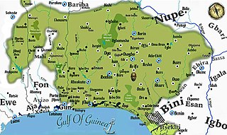
Yorubaland is the homeland and cultural region of the Yoruba people in West Africa. It spans the modern-day countries of Nigeria, Togo and Benin, and covers a total land area of 142,114 km2 (54,871 sq mi). Of this land area, 106,016 km2 (74.6%) lies within Nigeria, 18.9% in Benin, and the remaining 6.5% is in Togo. Prior to European colonization, a portion of this area was known as Yoruba country. The geo-cultural space contains an estimated 55 million people, the majority of this population being ethnic Yoruba.

Nigeria has 774 local government areas (LGAs), each administered by a local government council consisting of a chairman, who is the chief executive, and other elected members, who are referred to as councillors. Each LGA is further subdivided into a minimum of ten and a maximum of twenty wards. A ward is administered to by a councillor, who reports directly to the LGA chairman. The councillors fall under the legislative arm of the local government, the third tier of government in Nigeria, below the state governments and the federal government.
Biu is a town and a Local Government Area (LGA) in southern Borno State of Nigeria. The town is the administrative center of the LGA and was once the capital of the Biu kingdom, and is now capital of the Biu Emirate. Biu lies on the Biu Plateau at an average elevation of 626 meters. The region is semi-arid.

Ukwa West is a Local Government Area in Abia State, Nigeria. Its headquarters is in the town of Oke Ikpe.
Eddalands is an entire local government area in Ebonyi State, Nigeria. It is the most homogeneous LGA in Nigeria with people of one language, one culture and one tradition across the entire LGA.

Enugu North is a Local Government Area of Enugu State, Nigeria. Its headquarters are in the city of Enugu at Opkara Avenue. The LGA is made up of four main district areas Amaigbo Lane, Onuato, Umunevo and Ihenwuzi. Enugu North is one of the seventeen local governments in Enugu state and also one of the three LGA's that made up the Enugu Town - plus Enugu East and Enugu South.
Kaduna South is a Local Government Area in the Kaduna Metropolis of Kaduna State, Nigeria. It headquarters is located in Makera. Other wards are Barnawa, Tudun Wada,Tudun Nupawa, Television, Kakuri, Unguwar Muazu, Kabala West, Sabon Gari, Badikko, Unguwar Sanusi and Kurmin Mashi. It has an area of about 46.2 km2. The postal code of the area is 800.
Kagarko is a Local Government Area in southern Kaduna State of Nigeria. Its headquarters are in the town of Kagarko. It has an area of 2,356 km2 and a population of 239,058 at the 2006 census. The Local Government Council is chaired by Nasara Rabo. The postal code is 802.
Kachia is a Local Government Area in the southern part of Kaduna State, Nigeria. Its headquarters are in the town of Kachia. It has an area of 4,570 km2 and a population of 252,568 in the 2006 census. The postal code of the area is 802.
Zangon Kataf is a Local Government Area in southern Kaduna State, Nigeria. Its headquarters is in the town of Zonkwa. It is also a name of a town in the chiefdom of the Atyap. Other towns include: Batadon (Madakiya), Chenkwon, Kamantan, Anchuna and Kamuru. It has an area of 2,579 km2 and a population of 318,991 at the 2006 census. The postal code of the area is 802.
Kauru is a Local Government Area in southern Kaduna State, Nigeria. The area is 3,186 km2. Its headquarters are in the town of Kauru. The postal code of the area is 811.
Ido is a Local Government Area in Oyo State, Nigeria. Its headquarters are in the town of Ido.

Egbeda is a Local Government Area in the senatorial district of Oyo central in Ibadan less city of Oyo State, Nigeria. Its headquarters are in the town of Egbeda. Egbeda local government was carved out Lagelu Local government in 1989. The postal code of the area is 200109

Ibadan North is a Local Government Area in Oyo State, Nigeria. Its headquarters stood at Agodi in Ibadan. The postal code of the area is 200.
Ibadan North-East is a Local Government Area in Oyo State, Nigeria. Its headquarters are on Iwo Road. The postal code of the area is 200.
Ibadan South-West is a Local Government Area in Oyo State, Nigeria. Its headquarters are at Oluyole Estate in Ibadan. Its areas or districts include Ring-Road, Oke-Ado, Oke-Bola Gege, Born-Photo, and Isale-Osi.
Saki East is a Local Government Area in Oyo State, Nigeria. Its headquarters are in the town of Ago-Amodu.
Ife North is a Local Government Area in Osun State, Nigeria. Its headquarters are in the town of Ipetumodu in the north of the area at7°31′00″N4°27′00″E.


