Omer, Michigan

Last updated

Omer, Michigan
City of Omer
OmerMichigan sign.jpg
Signage along U.S. Highway 23
Omer, MI location.png
Location within Arenac County
USA Michigan location map.svg
Red pog.svg
Omer
Location within the state of Michigan
Usa edcp location map.svg
Red pog.svg
Omer
Location within the United States
Coordinates: 44°02′51″N83°51′16″W / 44.04750°N 83.85444°W / 44.04750; -83.85444 Coordinates: 44°02′51″N83°51′16″W / 44.04750°N 83.85444°W / 44.04750; -83.85444
CountryUnited States
State Michigan
County Arenac
Settled1866
Incorporated1903
Government
  Type Council–manager
   Mayor Lawrence Lee
   Clerk Susan Hegenauer
Area
[1]
  Total1.16 sq mi (3.00 km2)
  Land1.13 sq mi (2.93 km2)
  Water0.03 sq mi (0.07 km2)
Elevation
610 ft (186 m)
Population
 (2020)
  Total274
  Density242.05/sq mi (93.42/km2)
Time zone UTC-5 (Eastern (EST))
  Summer (DST) UTC-4 (EDT)
ZIP code(s)
48749
Area code 989
FIPS code 26-60660 [2]
GNIS feature ID0634057 [3]

Omer is a city in Arenac County in the U.S. state of Michigan. The population was 274 at the 2020 census, which ranks it as the least-populated city in the state.

Contents

Omer is consistently ranked as "Michigan's Smallest City" in terms of population, although the city of Lake Angelus held this distinction when it recorded a lower population at the 2010 census. Lake Angelus recorded a higher population of 287 at the 2020 census, making Omer again the state's least-populated city.

History

The Second Arenac County Courthouse is listed on the National Register of Historic Places and is now home to the Arenac County Historical Society. Second Arenac County Courthouse - Omer Michigan.jpg
The Second Arenac County Courthouse is listed on the National Register of Historic Places and is now home to the Arenac County Historical Society.

Omer was founded by George Gorie and George Carscallen, who set up a sawmill along the Rifle River in 1866. The town was originally named Rifle River Mills, but Carscallen, the first postmaster, wanted to rename the town Homer. However, he found a post office in another town called Homer, Michigan and simply dropped the leading H, producing the final name. The community received a station on the Detroit and Mackinaw Railroad, while in 1872 the area was platted. In 1883, Omer was split off from Bay County into the newly formed Arenac County. [4]

Omer was incorporated as a city in 1903. [5] A fire in 1914 almost eliminated the city, destroying 40 buildings and ending the early thrive that Omer had. Two years later, a flood curtailed rebuilding efforts by washing out the local dam.

Omer is the location of the story of the "cussing canoeist", the man who received a ticket under a century-old law for shouting a long stream of expletives in the presence of a woman and her two young children after he fell out of a canoe on the Rifle River. The American Civil Liberties Union intervened on the canoeist's behalf and got the law struck down in court. [5]

A second news story of note concerned the successful secession of two households from the city because the City of Omer was charging them a water tax while refusing to deliver water service to their property. [6] [7]

Geography

According to the United States Census Bureau, the city has a total area of 1.16 square miles (3.00 km2) of which 1.13 square miles (2.93 km2) is land and 0.03 square miles (0.08 km2) (2.59%) is water. [1]

The Rifle River runs through the city, which is a prominent fishing location for sucker fish in the spring. An annual festival and fishing tournament are held in Omer. [8]

Major highways

Demographics

Historical population
CensusPop.
1910 367
1920 266−27.5%
1930 216−18.8%
1940 29536.6%
1950 3218.8%
1960 3220.3%
1970 36613.7%
1980 40310.1%
1990 385−4.5%
2000 337−12.5%
2010 313−7.1%
2020 274−12.5%
U.S. Decennial Census [9]

2010 census

As of the census [10] of 2010, there were 313 people, 131 households, and 82 families residing in the city. The population density was 277.0 inhabitants per square mile (107.0/km2). There were 162 housing units at an average density of 143.4 per square mile (55.4/km2). The racial makeup of the city was 94.2% White, 0.3% African American, 4.2% Native American, 0.3% from other races, and 1.0% from two or more races.

There were 131 households, of which 32.1% had children under the age of 18 living with them, 41.2% were married couples living together, 13.0% had a female householder with no husband present, 8.4% had a male householder with no wife present, and 37.4% were non-families. 28.2% of all households were made up of individuals, and 13.7% had someone living alone who was 65 years of age or older. The average household size was 2.39 and the average family size was 2.84.

The median age in the city was 40.8 years. 22.4% of residents were under the age of 18; 8.6% were between the ages of 18 and 24; 25% were from 25 to 44; 26.2% were from 45 to 64; and 17.9% were 65 years of age or older. The gender makeup of the city was 50.2% male and 49.8% female.

2000 census

As of the census [2] of 2000, there were 337 people, 143 households, and 98 families residing in the city. The population density was 272.2 inhabitants per square mile (105.1/km2). There were 163 housing units at an average density of 131.7 per square mile (50.8/km2). The racial makeup of the city was 95.85% White, 1.19% Native American, 0.59% from other races, and 2.37% from two or more races. Hispanic or Latino of any race were 1.78% of the population.

There were 143 households, out of which 26.6% had children under the age of 18 living with them, 54.5% were married couples living together, 10.5% had a female householder with no husband present, and 30.8% were non-families. 24.5% of all households were made up of individuals, and 13.3% had someone living alone who was 65 years of age or older. The average household size was 2.36 and the average family size was 2.82.

In the city, the population was spread out, with 22.6% under the age of 18, 7.1% from 18 to 24, 26.1% from 25 to 44, 25.2% from 45 to 64, and 19.0% who were 65 years of age or older. The median age was 40 years. For every 100 females, there were 97.1 males. For every 100 females age 18 and over, there were 96.2 males.

The median income for a household in the city was $28,125, and the median income for a family was $33,250. Males had a median income of $26,607 versus $21,250 for females. The per capita income for the city was $16,755. About 12.4% of families and 15.2% of the population were below the poverty line, including 15.8% of those under age 18 and 16.7% of those age 65 or over.

Related Research Articles

<span class="mw-page-title-main">Arenac County, Michigan</span> County in Michigan, United States

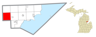
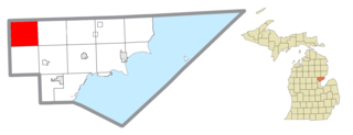
Arenac County is a county located in the U.S. state of Michigan. As of the 2020 Census, the population was 15,002. The county seat is Standish.

<span class="mw-page-title-main">Adams Township, Arenac County, Michigan</span> Civil township in Michigan, United States

Adams Township is a civil township of Arenac County in the U.S. state of Michigan. As of the 2010 census, the township population was 563.

<span class="mw-page-title-main">Arenac Township, Michigan</span> Civil township in Michigan, United States

Arenac Township is a civil township of Arenac County in the U.S. state of Michigan. As of the 2010 census, the township population was 903. The city of Omer is surrounded by the township but is administered autonomously.

<span class="mw-page-title-main">Au Gres, Michigan</span> City in Michigan, United States

Au Gres is a city in Arenac County in the U.S. state of Michigan. The population was 889 at the 2010 census.

<span class="mw-page-title-main">Au Gres Township, Michigan</span> Civil township in Michigan, United States

Au Gres Township is a civil township of Arenac County in the U.S. state of Michigan. As of the 2010 census, the township population was 953. The city of Au Gres borders the township to the east but both are administered autonomously.

<span class="mw-page-title-main">Clayton Township, Arenac County, Michigan</span> Civil township in Michigan, United States

Clayton Township is a civil township of Arenac County in the U.S. state of Michigan. The population was 1,097 at the 2010 census.

<span class="mw-page-title-main">Deep River Township, Michigan</span> Civil township in Michigan, United States

Deep River Township is a civil township of Arenac County in the U.S. state of Michigan. The population was 2,149 at the 2010 census. The village of Sterling is located within the township.

<span class="mw-page-title-main">Lincoln Township, Arenac County, Michigan</span> Civil township in Michigan, United States

Lincoln Township is a civil township of Arenac County in the U.S. state of Michigan. The population was 942 at the 2010 census. The city of Standish borders the township on the northeast but is administered autonomously.

<span class="mw-page-title-main">Mason Township, Arenac County, Michigan</span> Civil township in Michigan, United States

Mason Township is a civil township of Arenac County in the U.S. state of Michigan. The population was 851 at the 2010 census. The western portion of the village of Twining is located within the township.

<span class="mw-page-title-main">Moffatt Township, Michigan</span> Civil township in Michigan, United States

Moffatt Township is a civil township of Arenac County in the U.S. state of Michigan. The population was 1,184 at the 2010 census.

<span class="mw-page-title-main">Sims Township, Michigan</span> Civil township in Michigan, United States

Sims Township is a civil township of Arenac County in the U.S. state of Michigan. The population was 1,095 at the 2010 census.

<span class="mw-page-title-main">Standish, Michigan</span> City in Michigan, United States

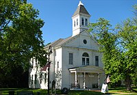
Standish is a city in the U.S. state of Michigan. The population was 1,458 at the 2020 census. It is the county seat of Arenac County.

<span class="mw-page-title-main">Standish Township, Michigan</span> Civil township in Michigan, United States

Standish Township is a civil township of Arenac County in the U.S. state of Michigan. The population was 1,900 at the 2010 census. The city of Standish borders the township on the northwest but is administered autonomously.

<span class="mw-page-title-main">Turner Township, Michigan</span> Civil township in Michigan, United States

Turner Township is a civil township of Arenac County in the U.S. state of Michigan. As of the 2010 census, it had a population of 550. The villages of Turner and the eastern portion of Twining are located within the township.

<span class="mw-page-title-main">Whitney Township, Michigan</span> Civil township in Michigan, United States

Whitney Township is a civil township of Arenac County in the U.S. state of Michigan. The population was 1,001 at the 2010 census.

Sherman Township is a civil township of Iosco County in the U.S. state of Michigan. The population was 493 at the 2000 census and slightly decreased to 448 at the 2010 census.

Whittemore is a city in Iosco County in the U.S. state of Michigan. The population was 414 at the 2020 census, which ranks it as the fourth-least populated city in the state after Omer, Lake Angelus, and Gaastra.

<span class="mw-page-title-main">Churchill Township, Michigan</span> Civil township in Michigan, United States

Churchill Township is a civil township of Ogemaw County in the U.S. state of Michigan. The population was 1,713 at the 2010 census.

<span class="mw-page-title-main">Zilwaukee, Michigan</span> City in Michigan, United States

Zilwaukee is a city in Saginaw County in the U.S. state of Michigan. The 2010 census places the population at 1,658. The city is adjacent to and was created from Zilwaukee Township. It is the home of the Zilwaukee Bridge.

<span class="mw-page-title-main">Woodhaven, Michigan</span> City in Michigan, United States

Woodhaven is a city in Wayne County in the U.S. state of Michigan. As of the 2010 census, the city had a population of 12,875. It is part of a collection of communities known as Downriver.

References

  1. 1 2 "2020 U.S. Gazetteer Files". United States Census Bureau. Retrieved May 21, 2022.
  2. 1 2 "U.S. Census website". United States Census Bureau. Retrieved January 31, 2008.
  3. U.S. Geological Survey Geographic Names Information System: Omer, Michigan
  4. Romig, Walter (1986). Michigan Place Names: The History of the Founding and the Naming of More Than Five Thousand Past and Present Michigan Communities. Great Lakes Books Series. Detroit: Wayne State University Press. p. 415. ISBN   978-0814318386.
  5. 1 2 "The 18 tiniest cities in Michigan". Flint Journal. Mlive Media Group. December 4, 2016. p. 21. Retrieved December 5, 2016.
  6. Seidel, Jeff (December 22, 2002). "City limits: Tiny Omer, Mich., votes on secession and what community really means". Detroit Free Press. Archived from the original on December 28, 2002.
  7. Reynolds, Dean. "Taxed for Nothing? Family Wants to Secede From Small Michigan Town Over $41.62". ABC News. Archived from the original on June 14, 2004.
  8. Payne, Amy L. (March 28, 2008). "Sucker revival: Omer hosting new tournament, festivities during annual sucker run on the Rifle River". MLive.com.
  9. "Census of Population and Housing". United States Census Bureau. Retrieved June 4, 2015.
  10. "U.S. Census website". United States Census Bureau. Retrieved November 25, 2012.